Suomussalmi
You can help expand this article with text translated from the corresponding article in Finnish. (June 2023) Click [show] for important translation instructions.
|
Suomussalmi | |
|---|---|
Municipality | |
| Suomussalmen kunta Suomussalmi kommun | |
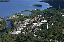
 An aerial view of Ämmänsaari, an administrative center of Suomussalmi | |
 Location of Suomussalmi in Finland | |
| Coordinates: 64°53′N 028°55′E / 64.883°N 28.917°E | |
| Country | |
| Region | Kainuu |
| Sub-region | Kehys-Kainuu |
| Charter | 1867 |
| Seat | Ämmänsaari |
| Government | |
| • Municipal manager | Erno Heikkinen |
| Area (2018-01-01)[1] | |
• Total | 5,857.60 km2 (2,261.63 sq mi) |
| • Land | 5,270.33 km2 (2,034.89 sq mi) |
| • Water | 587.03 km2 (226.65 sq mi) |
| • Rank | 9th largest in Finland |
| Population (2024-10-31)[2] | |
• Total | 7,079 |
| • Rank | 131st largest in Finland |
| • Density | 1.34/km2 (3.5/sq mi) |
| Population by native language | |
| • Finnish | 96.7% (official) |
| • Swedish | 0.1% |
| • Others | 3.2% |
| Population by age | |
| • 0 to 14 | 10.1% |
| • 15 to 64 | 52% |
| • 65 or older | 37.9% |
| Time zone | UTC+02:00 (EET) |
| • Summer (DST) | UTC+03:00 (EEST) |
| Website | www |
Suomussalmi (Finnish: [ˈsuo̯muˌsːɑlmi]) is a municipality in Finland and is located in the Kainuu region about 90 kilometres (56 mi) northeast of Kajaani, the capital of Kainuu and 120 kilometres (75 mi) south of Kuusamo. The municipality has a population of 7,079 (31 October 2024)[2] and covers an area of 5,857.60 square kilometres (2,261.63 sq mi) of which 587.03 km2 (226.65 sq mi) is water.[1] The population density is 1.34 inhabitants per square kilometre (3.5/sq mi). The municipality is unilingually Finnish. Ämmänsaari is the biggest built-up area in the municipality.
Suomussalmi is the second southernmost part of the reindeer-herding area in Finland.
History
[edit]During the Winter War of 1939–40, several battles were fought in the area around Suomussalmi, the most important ones being the Battle of Suomussalmi and the Battle of Raate Road. In these battles, Finnish forces defeated numerically superior Soviet forces.
Suomussalmi hosted the 2016 World Berry Picking Championship.[6]
Villages
[edit]- Alajärvi
- Ala-Vuokki
- Hossa
- Jumaliskylä
- Juntusranta
- Kaljuskylä
- Kerälä
- Kiannanniemi
- Korpela
- Korvua
- Kuivajärvi
- Kurimo
- Lomakylä
- Myllylahti
- Näljänkä
- Näätälä
- Peranka
- Pesiökylä
- Pesiönlahti
- Piispajärvi
- Pisto
- Pitämä
- Pyhäkylä
- Raate
- Ruhtinansalmi
- Sakara
- Selkoskylä
- Siikaranta
- Suomussalmi (Kirkonkylä)
- Tervakangas
- Vaaranniva
- Vasara
- Vuokki
- Yli-Vuokki
- Ämmänsaari (administrative center)
Kuivajärvi and Hietajärvi, located close to the Russian border, have long belonged to the poetic villages of White Karelia, and the Karelian language, Viena Karelian, has traditionally been spoken in the area.[7][8][9]
Transport
[edit]Highway 5 (E63) comes from Hyrynsalmi via Suomussalmi to Kuusamo. The rest of the municipality's most important roads are mainly smaller regional roads; regional road 912 from Kuhmo comes to Suomussalmi, regional road 843 from Palovaara to Suomussalmi continues to Kuusamo's Poussuu, regional road 892 runs from Suomussalmi through Korpikylä and Kytömäki to Hyrynsalmi, regional road 897 takes you from Alajärvi from Suomussalmi via Hattuvaara to Yli-Näljänkä, and connecting road 9125 or Raatteentie (also included parts of the current regional road 912) is a connecting road from Raatteenportti to Raate in the municipality of Suomussalmi, which was named after the Battle of Raate in 1940.
Politics
[edit]Results of the 2011 Finnish parliamentary election in Suomussalmi:
- Left Alliance 36.3%
- Centre Party 30.9%
- Finns Party 20.5%
- National Coalition Party 5.2%
- Social Democratic Party 3.1%
- Christian Democrats 2.3%
- Green League 0.9%
- Other parties 0.8%
Notable people
[edit]
- K. J. Ståhlberg (1865–1952), first president of Finland
- Hannes Tauriainen (1909–1971), politician
- Alho Alhoniemi (born 1933), linguist
- Toini Gustafsson (born 1938), former cross-country skier
- Matti Makkonen (1952–2015), engineer
- Osmo Tapio Räihälä (born 1964), composer
- Tero Penttilä (born 1975), former professional footballer
- Merja Kyllönen (born 1977), politician
- Heikki Kovalainen (born 1981), racing driver
- Janne Pesonen (born 1982), former professional ice hockey player
International relations
[edit]Twin towns — Sister cities
[edit]Suomussalmi is twinned with:
 Kalevala, Russia
 Nordmaling Municipality, Sweden
References
[edit]- ^ a b "Area of Finnish Municipalities 1.1.2018" (PDF). National Land Survey of Finland. Retrieved 30 January 2018.
- ^ a b "Finland's preliminary population figure was 5,635,560 at the end of October 2024". Population structure. Statistics Finland. 2024-11-19. ISSN 1797-5395. Retrieved 2024-11-22.
- ^ "Population growth biggest in nearly 70 years". Population structure. Statistics Finland. 2024-04-26. ISSN 1797-5395. Retrieved 2024-04-29.
- ^ "Population according to age (1-year) and sex by area and the regional division of each statistical reference year, 2003–2020". StatFin. Statistics Finland. Retrieved 2 May 2021.
- ^ a b "Luettelo kuntien ja seurakuntien tuloveroprosenteista vuonna 2023". Tax Administration of Finland. 14 November 2022. Retrieved 7 May 2023.
- ^ C.G. (11 October 2017). "Explaining the Finnish love of tango". The Economist.
- ^ "Kuivajärvi ja Hietajärvi". www.juminkeko.fi (in Finnish). Retrieved 2021-06-14.
- ^ "Kartta runokylien alueesta". www.juminkeko.fi (in Finnish). Retrieved 2021-06-14.
- ^ "Kotus. Karjalan kieli, kartta" (in Finnish). Kotimaisten kielten keskus. Retrieved 2021-06-14.
External links
[edit]![]() Media related to Suomussalmi at Wikimedia Commons
Media related to Suomussalmi at Wikimedia Commons
![]() Suomussalmi travel guide from Wikivoyage
Suomussalmi travel guide from Wikivoyage
- Municipality of Suomussalmi – Official website


