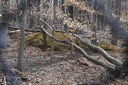
"A" Fort and Battery Hill Redoubt-Camp Early
Appearance
"A" Fort and Battery Hill Redoubt-Camp Early | |
 Traces of Confederate redoubts and trenches are visible | |
| Location | Balmoral Greens Ave., 1 mile (1.6 km) south of the junction with Compton Rd., Fairfax County, Virginia |
|---|---|
| Coordinates | 38°47′22″N 77°25′40″W / 38.78944°N 77.42778°W |
| Area | 25 acres (10 ha) |
| Built | 1862 |
| NRHP reference No. | 98001315[1] |
| VLR No. | 029-5006 |
| Significant dates | |
| Added to NRHP | October 30, 1998 |
| Designated VLR | June 17, 1998[2] |
"A" Fort and Battery Hill Redoubt-Camp Early, also known as Measles Fort, is a historic American Civil War military facility and redoubt located in Fairfax County, Virginia south of Centreville and along Bull Run.
It was listed on the National Register of Historic Places in 1998.[1]
References
[edit]- ^ a b "National Register Information System – "A" Fort and Battery Hill Redoubt--Camp Early (#98001315)". National Register of Historic Places. National Park Service. July 9, 2010.
- ^ "Virginia Landmarks Register". Virginia Department of Historic Resources. Archived from the original on 21 September 2013. Retrieved 5 June 2013.
Categories:
- Forts on the National Register of Historic Places in Virginia
- Government buildings completed in 1862
- National Register of Historic Places in Fairfax County, Virginia
- 1862 establishments in Virginia
- American Civil War on the National Register of Historic Places
- Northern Virginia Registered Historic Place stubs
- Fairfax County, Virginia, geography stubs


