Wikipedia:Featured picture candidates/Ph map manila.svg
Appearance

- Reason
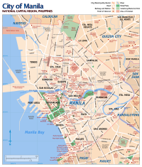
- an older rasterized version is FP, and now the creator have posted an updated vector version of the map, I propose that this version shall take the status from the raster version (Image:Ph map manila large.png)
- Articles this image appears in
- Manila etc...
- Creator
- commons:User:Seav
- Nominator
- →AzaToth
- Support — →AzaToth 10:23, 8 January 2007 (UTC)
- Support Easy to read and has good color coordination. Why1991 13:09, 8 January 2007 (UTC)
- Replace per nom. —Dgiest c 15:58, 8 January 2007 (UTC)
- Replace per nom. I can see no drawbacks in the SVG version. It has no apprent rendering problems and looks clear and professional. --Dschwen 17:02, 8 January 2007 (UTC)
- Support of course. Good job --frothT C 17:45, 8 January 2007 (UTC)
- questions - is north up? What is the double arrow that appears to the southeast(?) of Mandaluyong city? Debivort 17:56, 8 January 2007 (UTC)
- That's a symbol used on maps to indicate exclaves. Presumably, Manila South Cemtery is a part of Manila despite being surrounded by Makati. —Cuiviénen 23:29, 8 January 2007 (UTC)
- Ok. I will add a compass rose/arrow to indicate north. But yes, north is straight up. =) --seav 03:43, 9 January 2007 (UTC)
- Replace. SVG beats PNG again, but I would like to see a compass rose or at least some indication of North. --Tewy 21:41, 8 January 2007 (UTC)
- Comment. The resolution should be upped considerably; most viewers will not have an easy way/knowledge of how to make it large enough to read.--ragesoss 03:23, 9 January 2007 (UTC)
- This is the SVG version. The PNG version is large enough to read on most users' browsers. --Tewy 03:26, 9 January 2007 (UTC)
- Right. It's SVG, so native size is just a parameter; it's trivial to make it larger, so what reason is there not to?--ragesoss 03:42, 9 January 2007 (UTC)
- I don't think you can make it large enough on the image page alone to read the small text. There's a link to the PNG version on the image page, so you can click that if you don't have the software for viewing SVG. --Tewy 03:56, 9 January 2007 (UTC)
- Right. It's SVG, so native size is just a parameter; it's trivial to make it larger, so what reason is there not to?--ragesoss 03:42, 9 January 2007 (UTC)
- This is the SVG version. The PNG version is large enough to read on most users' browsers. --Tewy 03:26, 9 January 2007 (UTC)
- Conditional Support/Replace pending addition of a compass bearing somewhere on the image. No real reason not to have one (plenty of whitespace out in the bay). GeeJo (t)⁄(c) • 06:17, 9 January 2007 (UTC)
- Neutral for now. Agree with others, a compass rose is needed as well as some geographic coordinate reference (one position would be enough). Other issues: why are the Manila International Airport and the Manila Harbor Center cut? And what is the weird looking arrow joining the Manila South Cemetery and Sta. Ana Church: the north-south direction? - Alvesgaspar 09:02, 9 January 2007 (UTC)
- For the "weird looking arrow", I'll quote Cuivienen's answer from farther up the page: That's a symbol used on maps to indicate exclaves. Presumably, Manila South Cemtery is a part of Manila despite being surrounded by Makati. GeeJo (t)⁄(c) • 12:14, 9 January 2007 (UTC)
- The Manila International Port Terminal and the Manila Harbour Center are cut off because I don't think I need to indicate how far they go out into the bay. The point of this map is to show where the places are. Is it really important that these two are not cut off? The weird arrow does indicate that the cemetery in an exclave. I'll probably add some coordinate references. Any other issues? --seav 11:03, 10 January 2007 (UTC)
- Info I've updated the image and added an north arrow and a coordinate grid. --seav 16:47, 10 January 2007 (UTC)
- Support/Replace Nice map, good to have in SVG. Thanks for your improvements. TSP 01:50, 11 January 2007 (UTC)
- Help The svg image is not being shown in WP and the png version does not correspond to the actual map. For those who cannot see svg images directly the only way to view the map is to download the file and open it with some svg application. - Alvesgaspar 10:14, 11 January 2007 (UTC)
- Support or Replace per AzaToth. S h a r k f a c e 2 1 7 20:41, 12 January 2007 (UTC)
Promoted Image:Ph_map_manila.svg to replace the old version. Raven4x4x 07:17, 16 January 2007 (UTC)
- Support — Scorpion prinz 16:38, 24 January 2007 (UTC)
