Werther, North Rhine-Westphalia
Appearance
(Redirected from Werther (Westfalen))
Werther (Westf.) | |
|---|---|
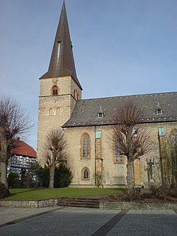
 Protestant St. Jacobi in the centre of Werther | |
Location of Werther (Westf.) within Gütersloh district  | |
| Coordinates: 52°04′30″N 08°24′45″E / 52.07500°N 8.41250°E | |
| Country | Germany |
| State | North Rhine-Westphalia |
| Admin. region | Detmold |
| District | Gütersloh |
| Subdivisions | 6 |
| Government | |
| • Mayor (2020–25) | Veith Lemmen[1] (SPD) |
| Area | |
• Total | 35.31 km2 (13.63 sq mi) |
| Elevation | 316 m (1,037 ft) |
| Population (2023-12-31)[2] | |
• Total | 11,193 |
| • Density | 320/km2 (820/sq mi) |
| Time zone | UTC+01:00 (CET) |
| • Summer (DST) | UTC+02:00 (CEST) |
| Postal codes | 33824 |
| Dialling codes | 05203 |
| Vehicle registration | GT |
| Website | www.stadt-werther.de |
Werther is a town in the district of Gütersloh in the state of North Rhine-Westphalia, Germany. It is located near the Teutoburg Forest, approximately 10 km (6 miles) north-west of Bielefeld. It is best known for the Werther's Original caramel sweets, which are nowadays produced in the nearby city of Halle. Werther has one Gesamtschule and one Gymnasium, which has an exchange partnership with a Yarm School, an independent school in Yarm, England.
People
[edit]- August Oberwelland, entrepreneur, August Storck company founder
References
[edit]- ^ Wahlergebnisse in NRW Kommunalwahlen 2020, Land Nordrhein-Westfalen, accessed 21 June 2021.
- ^ "Bevölkerung der Gemeinden Nordrhein-Westfalens am 31. Dezember 2023 – Fortschreibung des Bevölkerungsstandes auf Basis des Zensus vom 9. Mai 2011" (in German). Landesbetrieb Information und Technik NRW. Retrieved 2024-06-20.


