Masterton East
Masterton East | |
|---|---|
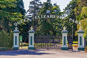
 Queen Elizabeth Park entrance | |
 | |
| Coordinates: 40°57′30″S 175°39′56″E / 40.958202°S 175.665622°E | |
| Country | New Zealand |
| City | Masterton |
| Local authority | Masterton District Council |
| Area | |
| • Land | 240 ha (590 acres) |
| Population (June 2024)[2] | |
• Total | 4,300 |
| Masterton West | Masterton Central | Lansdowne |
| Kuripuni |
|
|
| Solway |
Masterton East (also known as Eastside or Cameron Block) is a suburb of Masterton, a town on New Zealand's North Island.
It is a low socio-economic area with social housing, with about 15% of Masterton's population. About 30% of the population are Māori, primarily belonging to Rangitāne and Ngāti Kahungunu.[3]
A central feature of the park is McJorrow Park, a soccer park. Playgrounds, an asphalt basketball court, a sunshade, seating and outside tables were installed in the park between 2015 and 2017.[4]
The park features Te Awhina Cameron Community House, a community centre that hosts English as a Second Language classes, playgroup, cooking classes and furniture workshops. The building was renovated between 2013 and 2014.[5]
In 2018, Masterton District Council and the Eastside Community Group worked on a project to slow vehicles through the area. Some cars were significantly damaged by one steep obstacle installed on River Road.[6]
Later the same year, Massey University students developed ideas to improve the area, including further road changes and turning graffiti into public art.[3] The ideas was passed on to the Eastside Community Group to consider.[7]
Demographics
[edit]Masterton East, comprising the statistical areas of Cameron and Soldiers Park and McJorrow Park, covers 2.40 km2 (0.93 sq mi).[1] It had an estimated population of 4,300 as of June 2024, with a population density of 1,792 people per km2.
| Year | Pop. | ±% p.a. |
|---|---|---|
| 2006 | 3,393 | — |
| 2013 | 3,576 | +0.75% |
| 2018 | 3,837 | +1.42% |
| Source: [8] | ||
Masterton East had a population of 3,837 at the 2018 New Zealand census, an increase of 261 people (7.3%) since the 2013 census, and an increase of 444 people (13.1%) since the 2006 census. There were 1,449 households, comprising 1,860 males and 1,977 females, giving a sex ratio of 0.94 males per female, with 822 people (21.4%) aged under 15 years, 816 (21.3%) aged 15 to 29, 1,533 (40.0%) aged 30 to 64, and 663 (17.3%) aged 65 or older.
Ethnicities were 72.0% European/Pākehā, 36.8% Māori, 7.6% Pasifika, 4.3% Asian, and 1.3% other ethnicities. People may identify with more than one ethnicity.
The percentage of people born overseas was 10.7, compared with 27.1% nationally.
Although some people chose not to answer the census's question about religious affiliation, 52.6% had no religion, 32.1% were Christian, 3.5% had Māori religious beliefs, 0.6% were Hindu, 0.2% were Muslim, 0.2% were Buddhist and 2.7% had other religions.
Of those at least 15 years old, 285 (9.5%) people had a bachelor's or higher degree, and 852 (28.3%) people had no formal qualifications. 171 people (5.7%) earned over $70,000 compared to 17.2% nationally. The employment status of those at least 15 was that 1,227 (40.7%) people were employed full-time, 426 (14.1%) were part-time, and 171 (5.7%) were unemployed.[8]
| Name | Area (km2) |
Population | Density (per km2) |
Households | Median age | Median income |
|---|---|---|---|---|---|---|
| Cameron and Soldiers Park | 1.49 | 2,160 | 1,450 | 909 | 43.3 years | $24,200[9] |
| McJorrow Park | 0.90 | 1,677 | 1,863 | 540 | 30.0 years | $20,300[10] |
| New Zealand | 37.4 years | $31,800 |
Education
[edit]Makoura College is a co-educational state secondary school for Year 9 to 13 students,[11] with a roll of 276 as of August 2024.[12] It was founded in 1968.[13]
The Wairarapa Teen Parent Unit is attached to the school.[14]
Te Kura Kaupapa Māori o Wairarapa is a co-educational state Māori language immersion area school for Year 1 to 15 students,[15] with a roll of 137.[16]
References
[edit]- ^ a b "ArcGIS Web Application". statsnz.maps.arcgis.com. Retrieved 22 January 2024.
- ^ "Aotearoa Data Explorer". Statistics New Zealand. Retrieved 26 October 2024.
- ^ a b "Planning students redesign Masterton's east side". Massey University. 23 November 2018.
- ^ "McJorrow Park bringing community back together". trusthouse.co.nz. Trust House. 1 August 2017.
- ^ Fuller, Piers (15 October 2014). "Masterton East Side project humming". Stuff. Dominion Post.
- ^ Roberts, Cal (4 October 2018). "Eastside go-slow takes off". Wairarapa Times-Age.
- ^ "University students float East Side ideas". Wairarapa Times-Age. 29 November 2018.
- ^ a b "Statistical area 1 dataset for 2018 Census". Statistics New Zealand. March 2020. Cameron and Soldiers Park (256400) and McJorrow Park (256700).
- ^ 2018 Census place summary: Cameron and Soldiers Park
- ^ 2018 Census place summary: McJorrow Park
- ^ "Makoura College Official School Website". mc.school.nz.
- ^ "Makoura College Ministry of Education School Profile". educationcounts.govt.nz. Ministry of Education.
- ^ "Makoura College Education Review Office Report". ero.govt.nz. Education Review Office.
- ^ "Wairarapa Teen Parent Unit Ministry of Education School Profile". educationcounts.govt.nz. Ministry of Education.
- ^ "Te Kura Kaupapa Māori o Wairarapa Ministry of Education School Profile". educationcounts.govt.nz. Ministry of Education.
- ^ "Te Kura Kaupapa Māori o Wairarapa Education Review Office Report". ero.govt.nz. Education Review Office.
