Ishøj
Ishøj | |
|---|---|
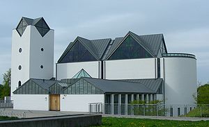
 Vejleå Church, the church in Ishøj | |
 | |
| Coordinates: 55°36′57″N 12°21′05″E / 55.61583°N 12.35139°E | |
| Country | Denmark |
| Region | Capital (Hovedstaden) |
| Municipality | Ishøj |
| Government | |
| • Mayor | Merete Amdisen |
| Area | |
• Total | 5.5 km2 (2.1 sq mi) |
| Population (1. January 2024)[1] | |
• Total | 21,465 |
| • Density | 3,900/km2 (10,000/sq mi) |
| Time zone | UTC+1 (Central Europe Time) |
| • Summer (DST) | UTC+2 |
Ishøj is a Danish town with a population of 21,465 (1. January 2024).[1] It is situated in the Region Hovedstaden, and is the seat of the Ishøj Municipality.
Geography
[edit]The town is located by the coast in the southwestern suburban area of Copenhagen and is part of the city's urban area.
Immigration
[edit]During the 1960s to 1980s, Denmark attracted a large number of foreign workers. Many of these workers chose to remain in the country, with a significant number settling in Ishøj, which is today known for its diverse population, with immigrants and their descendants accounting for 37.5 percent of the total population. This makes Ishøj the municipality with the highest proportion of immigrants in Denmark.[2]
The influx of immigrants has also had an impact on the local schools, with some municipal schools having over 30 percent of students who are bilingual.[3]
Notable people
[edit]- Karen Ankersted (1859 in Ishøj – 1921) a Danish teacher and pioneering female politician.
- Helle Thorning-Schmidt (born 1966) former Prime Minister of Denmark and Chief Executive of Save the Children, attended Ishøj Gymnasium
- Pia Olsen Dyhr (born 1971) a Danish politician who attended Ishøj Gymnasium
- Nadia Alawa (born 1971 in Ishøj) the founder and current CEO of the non-profit NuDay
- Peter Corp Dyrendal (born 1976 in Ishøj) a Danish-Thai descent singer, recording artist, actor and model
- ZK (born 2000 in Ishøj), stage name of Zaman Kilic, a Danish rapper
Sport
[edit]- Camilla Kur Larsen (born 1989 in Ishøj) a Danish professional soccer player
- Riza Durmisi (born 1994 in Ishøj) a Danish professional footballer
- Ertuğrul Tekşen (born 2000 in Ishøj) a Danish-born Turkish footballer who plays for TFF Third League club Belediye Kütahyaspor
- Zidan Sertdemir (born 2005 in Ishøj) a Danish-born Turkish footballer who plays for Bayer Leverkusen
- Thomas Frank, who taught at the college in 2004, is currently manager of Brentford F.C. in the Premier League.
See also
[edit]References
[edit]- ^ a b Population 1. January by urban areas, area and population density The Mobile Statbank from Statistics Denmark
- ^ "Socialt ansvar og uddannelse på Vestegnen" (PDF). Vestegnssamarbejdet (in Danish). August 2007. Retrieved 8 April 2023.
- ^ "Indvandrere i Danmark 2016". Danmarks Statistik (in Danish). November 2016. Retrieved 8 April 2023.
External links
[edit]![]() Media related to Ishøj at Wikimedia Commons
Media related to Ishøj at Wikimedia Commons
