Jump to content

List of tripoints of U.S. states

From Wikipedia, the free encyclopedia
(Redirected from Tripoint (United States))

This is a list of all tripoints in which the boundaries of three (and only three) U.S. states converge at a single geographic point. Of the 60 such points, 36 are on dry land and 24 are in water.[1] Of the points in water, 3 are in the Great Lakes and thus have no land nearby. A tripoint occurring in a populated area may also be informally described as a tri-state area.

Land

[edit]
State 1 State 2 State 3 Coordinates Notes
Alabama Florida Georgia 31°0′2″N 85°0′8″W / 31.00056°N 85.00222°W / 31.00056; -85.00222 Marker on Chattahoochee riverbank is actually a few feet above and west of true tripoint at high-water line.[2]
Alabama Georgia Tennessee 34°59′5″N 85°36′19″W / 34.98472°N 85.60528°W / 34.98472; -85.60528 Tri-State Corner. Marker on dry land at surface level and unmarked on lake in cavern directly below. Stolen in 2009 and returned two years later.[3][4][5]
Arizona Nevada Utah 37°0′1″N 114°3′2″W / 37.00028°N 114.05056°W / 37.00028; -114.05056 Marked with a red sandstone monument.[6]
Arkansas Louisiana Mississippi 33°0′15″N 91°9′58″W / 33.00417°N 91.16611°W / 33.00417; -91.16611 Probably unmarked on silt island in river sometimes connected to west bank by mud flat accreted by riprap.
Arkansas Louisiana Texas 33°1′9″N 94°2′35″W / 33.01917°N 94.04306°W / 33.01917; -94.04306 See Ark-La-Tex. Marker in process of being surrounded and absorbed by tree.
Arkansas Missouri Oklahoma 36°29′58″N 94°37′5″W / 36.49944°N 94.61806°W / 36.49944; -94.61806 Marked with a stone monument.[7]
Arkansas Oklahoma Texas 33°38′16″N 94°29′9″W / 33.63778°N 94.48583°W / 33.63778; -94.48583 Unmarked on seasonal silt island or in river bed, but Oklahoma–Texas state line as revised in 2000 is defective in not extending from vegetation line on south bank to pre-established tripoint.
California Nevada Oregon 41°59′40″N 119°59′57″W / 41.99444°N 119.99917°W / 41.99444; -119.99917 Marked with a cairn.[8]
Colorado Kansas Nebraska 40°0′11″N 102°3′6″W / 40.00306°N 102.05167°W / 40.00306; -102.05167 Marked with a brass disc.[9]
Colorado Kansas Oklahoma 36°59′35″N 102°2′32″W / 36.99306°N 102.04222°W / 36.99306; -102.04222 8 Mile Corner. Marker is concealed in crypt beneath removable manhole cover.
Colorado Nebraska Wyoming 41°0′5″N 104°3′12″W / 41.00139°N 104.05333°W / 41.00139; -104.05333 Marked with a stone surrounded by a three-stone colored base.[10]
Colorado New Mexico Oklahoma 37°0′0″N 103°0′8″W / 37.00000°N 103.00222°W / 37.00000; -103.00222 Preston Monument
Colorado Utah Wyoming 41°0′2″N 109°3′0″W / 41.00056°N 109.05000°W / 41.00056; -109.05000 Marked.[11]
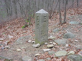
Connecticut Massachusetts New York 42°2′59″N 73°29′14″W / 42.04972°N 73.48722°W / 42.04972; -73.48722 See Brace Mountain or Mount Frissell. Marked with a stone inscribed with MASS-1898-NY and sometimes a "scratched-on" CONN.[12]
Connecticut Massachusetts Rhode Island 42°0′29″N 71°47′57″W / 42.00806°N 71.79917°W / 42.00806; -71.79917 See Thompson, Connecticut. Marked with a stone inscribed with MASS-CONN-RI.[13]
Delaware Maryland Pennsylvania 39°43′20″N 75°47′19″W / 39.72222°N 75.78861°W / 39.72222; -75.78861 Marked by the Tri-State Monument, inscribed with M-M-P-P. See Delaware Wedge.[14]
Georgia North Carolina Tennessee 34°59′18″N 84°19′19″W / 34.98833°N 84.32194°W / 34.98833; -84.32194 Marked.[15]
Idaho Montana Wyoming 44°28′27″N 111°2′56″W / 44.47417°N 111.04889°W / 44.47417; -111.04889 Located within Yellowstone National Park. Marked, although difficult to access.[16]
Idaho Nevada Oregon 42°0′1″N 117°1′34″W / 42.00028°N 117.02611°W / 42.00028; -117.02611 Marked with a three-sided stone inscribed with N-I-O on the respective faces.[17]
Idaho Nevada Utah 41°59′37″N 114°2′30″W / 41.99361°N 114.04167°W / 41.99361; -114.04167 Marked with a granite monument inscribed with the respective states' names.[18]
Idaho Utah Wyoming 42°0′6″N 111°2′48″W / 42.00167°N 111.04667°W / 42.00167; -111.04667 Marked with a stone.[19]
Indiana Michigan Ohio 41°41′46″N 84°48′22″W / 41.69611°N 84.80611°W / 41.69611; -84.80611 Brass marker with the shapes of the three states is located in a monument box beneath the surface of a rural road. Was set in 1999[20] and is referenced by a granite marker 20 feet to the east on the Michigan-Ohio line.[21]
Iowa Minnesota South Dakota 43°30′1″N 96°27′12″W / 43.50028°N 96.45333°W / 43.50028; -96.45333 True point is marked with a disc in the center of a T-shaped road intersection.[22] A witness monument nearby in the South Dakota corner acknowledges the tri-point being set in 1859.
Kansas Missouri Oklahoma 36°59′56″N 94°37′5″W / 36.99889°N 94.61806°W / 36.99889; -94.61806 Marked with a plaque on a seldom used dead-end road.[23]
Kentucky Tennessee Virginia 36°36′3″N 83°40′32″W / 36.60083°N 83.67556°W / 36.60083; -83.67556 Tri-State Peak[24] Located within Cumberland Gap National Historical Park. Marked.
Kentucky Virginia West Virginia 37°32′17″N 81°58′5″W / 37.53806°N 81.96806°W / 37.53806; -81.96806 Marked with a USCG marker on top of a two-foot high iron pipe at the river's high point.[25]
Maryland Pennsylvania West Virginia 39°43′16″N 79°28′36″W / 39.72111°N 79.47667°W / 39.72111; -79.47667 Marked with a pyramid-like stone.[26]
Massachusetts New Hampshire Vermont 42°43′37″N 72°27′30″W / 42.72694°N 72.45833°W / 42.72694; -72.45833 Marker is technically on dry land, but buried within river bed due to a dam's construction downstream.[27]
Massachusetts New York Vermont 42°44′45″N 73°15′54″W / 42.74583°N 73.26500°W / 42.74583; -73.26500 Marked with a stone.[28]
Minnesota North Dakota South Dakota 45°56′7″N 96°33′49″W / 45.93528°N 96.56361°W / 45.93528; -96.56361 Near the Bois de Sioux River[29]
Montana North Dakota South Dakota 45°56′43″N 104°2′44″W / 45.94528°N 104.04556°W / 45.94528; -104.04556 Marked with a red granite stone.[30]
Montana South Dakota Wyoming 44°59′51″N 104°3′28″W / 44.99750°N 104.05778°W / 44.99750; -104.05778 Marked with a stone within a fence.[31]
Nebraska South Dakota Wyoming 43°0′2″N 104°3′11″W / 43.00056°N 104.05306°W / 43.00056; -104.05306 Marked with a stone within a fence.[32]
New Jersey New York Pennsylvania 41°21′27″N 74°41′42″W / 41.35750°N 74.69500°W / 41.35750; -74.69500 Marked by the Tri-States Monument in Port Jervis, New York, at the confluence of the Delaware and Neversink rivers.[33][34]
New Mexico Oklahoma Texas 36°30′1″N 103°0′9″W / 36.50028°N 103.00250°W / 36.50028; -103.00250 Texhomex Marker
North Carolina Tennessee Virginia 36°35′17″N 81°40′39″W / 36.58806°N 81.67750°W / 36.58806; -81.67750 North Carolina–Tennessee–Virginia Corners - Marked.[35]

Water

[edit]
State 1 State 2 State 3 Coordinates Water Notes
Alabama Mississippi Tennessee 34°59′44″N 88°12′0″W / 34.99556°N 88.20000°W / 34.99556; -88.20000 Tennessee River
Arizona California Nevada 35°0′7″N 114°38′1″W / 35.00194°N 114.63361°W / 35.00194; -114.63361 Colorado River
Arkansas Mississippi Tennessee 34°59′44″N 90°18′33″W / 34.99556°N 90.30917°W / 34.99556; -90.30917 Mississippi River Memphis, Tennessee metro area.
Arkansas Missouri Tennessee 36°0′2″N 89°43′59″W / 36.00056°N 89.73306°W / 36.00056; -89.73306 Mississippi River
Connecticut New York Rhode Island 41°18′16″N 71°54′26″W / 41.30444°N 71.90722°W / 41.30444; -71.90722 Long Island Sound The part of New York that is in this tri-state area is Fishers Island. It is the New London, Connecticut metro area.
Delaware New Jersey Pennsylvania 39°48′7″N 75°24′54″W / 39.80194°N 75.41500°W / 39.80194; -75.41500 Delaware River Philadelphia metro area, at the east end of the Twelve-Mile Circle.
Georgia North Carolina South Carolina 35°0′2″N 83°6′31″W / 35.00056°N 83.10861°W / 35.00056; -83.10861 Chatooga River Located in river very near marker on dry land.[36]
Idaho Oregon Washington 45°59′43″N 116°54′58″W / 45.99528°N 116.91611°W / 45.99528; -116.91611 Snake River
Illinois Indiana Kentucky 37°47′57″N 88°1′41″W / 37.79917°N 88.02806°W / 37.79917; -88.02806 Wabash River and Ohio River Evansville, Indiana metro area. See Illinois–Indiana–Kentucky tri-state area.
Illinois Indiana Michigan 41°45′39″N 87°12′28″W / 41.76083°N 87.20778°W / 41.76083; -87.20778 Lake Michigan Known as either the Indiana Dunes or the Michigan Dunes Area
Illinois Iowa Wisconsin 42°30′30″N 90°38′27″W / 42.50833°N 90.64083°W / 42.50833; -90.64083 Mississippi River Dubuque, Iowa metro area.
Illinois Kentucky Missouri 36°58′51″N 89°8′3″W / 36.98083°N 89.13417°W / 36.98083; -89.13417 Mississippi River and Ohio River Little Egypt region popularly labeled as a tri-state area with St. Louis, Missouri, Carbondale, Illinois metro area and Paducah, Kentucky being its nuclei.
Illinois Michigan Wisconsin 42°29′37″N 87°1′12″W / 42.49361°N 87.02000°W / 42.49361; -87.02000 Lake Michigan
Indiana Kentucky Ohio 39°6′20″N 84°49′13″W / 39.10556°N 84.82028°W / 39.10556; -84.82028 Ohio River Cincinnati metro area. The tripoint is near, but not precisely at, the confluence with the Great Miami River.
Iowa Illinois Missouri 40°22′42″N 91°25′10″W / 40.37833°N 91.41944°W / 40.37833; -91.41944 Mississippi River and Des Moines River Border with Lee County, Iowa
Iowa Minnesota Wisconsin 43°30′2″N 91°13′4″W / 43.50056°N 91.21778°W / 43.50056; -91.21778 Mississippi River La Crosse, Wisconsin metro area. Was apparently marked at one time with a sign that had been anchored in the location, but that sign has since been moved as of 2001.[37]
Iowa Missouri Nebraska 40°35′7″N 95°45′56″W / 40.58528°N 95.76556°W / 40.58528; -95.76556 Missouri River
Iowa Nebraska South Dakota 42°29′26″N 96°26′44″W / 42.49056°N 96.44556°W / 42.49056; -96.44556 Big Sioux River and Missouri River Sioux City, Iowa metro area.
Kansas Missouri Nebraska 40°0′0″N 95°18′30″W / 40.00000°N 95.30833°W / 40.00000; -95.30833 Missouri River
Kentucky Missouri Tennessee 36°29′54″N 89°32′22″W / 36.49833°N 89.53944°W / 36.49833; -89.53944
36°29′52″N 89°29′6″W / 36.49778°N 89.48500°W / 36.49778; -89.48500
36°29′57″N 89°25′6″W / 36.49917°N 89.41833°W / 36.49917; -89.41833
Mississippi River Three separate tripoints, due to meanders of the river (though probably only a single tri-state area surrounding them all). See also Kentucky Bend.
Kentucky Ohio West Virginia 38°25′18″N 82°35′45″W / 38.42167°N 82.59583°W / 38.42167; -82.59583 Big Sandy River and Ohio River Huntington (W.V.)-Ashland (Ky.)-Ironton (Oh.) Tri-State region.
Maryland Virginia West Virginia 39°19′17″N 77°43′8″W / 39.32139°N 77.71889°W / 39.32139; -77.71889 Potomac River Unmarked, at high water mark, because the Maryland West Virginia state line is at the high water mark even tho the Maryland Virginia state line runs generally along the low water line, so perhaps misclassified here because it is rarely actually under water.[38]
Michigan Minnesota Wisconsin 47°17′28″N 89°57′26″W / 47.29111°N 89.95722°W / 47.29111; -89.95722 Lake Superior
Ohio Pennsylvania West Virginia 40°38′20″N 80°31′8″W / 40.63889°N 80.51889°W / 40.63889; -80.51889 Ohio River Technically the Beginning Point of the U.S. Public Land Survey, although the actual monument is 1,112 feet north of the tripoint due to the tripoint's current location under water; Pittsburgh Tri-State.

See also

[edit]

References

[edit]
  1. ^ "Tri State Corners in the United States" (PDF). Jack Parsell.
  2. ^ "Alabama–Florida–Georgia Tristate" (PDF). Bjbsoftware.com.
  3. ^ "Alabama–Georgia–Tennessee Tristate" (PDF). Bjbsoftware.com.
  4. ^ Wheatley, Thomas. "Camak Stone, border marker between Tennessee and Georgia, is missing". Creativeloafing.com. Retrieved May 7, 2017.
  5. ^ Vardeman, Johnny. "Stolen stone returns home minus fanfare". Gainesville Times. Retrieved May 7, 2017.
  6. ^ "Arizona–Nevada–Utah" (PDF). Bjbsoftware.com. Retrieved August 27, 2018.
  7. ^ "Arkansas–Missouri–Oklahoma" (PDF). Bjbsoftware.com. Retrieved August 27, 2018.
  8. ^ "Oregon–California–Nevada" (PDF). Bjbsoftware.com. Retrieved August 27, 2018.
  9. ^ "Colorado–Nebraska–Kansas" (PDF). Bjbsoftware.com. Retrieved August 27, 2018.
  10. ^ "Colorado–Nebraska–Wyoming" (PDF). Bjbsoftware.com. Retrieved August 27, 2018.
  11. ^ "Colorado–Utah–Wyoming" (PDF). Bjbsoftware.com. Retrieved August 27, 2018.
  12. ^ "Connecticut–Massachusetts–New York". Bjbsoftware.com. Retrieved August 27, 2018.
  13. ^ "Connecticut–Massachusetts–Rhode Island". Bjbsoftware.com. Retrieved August 27, 2018.
  14. ^ "Delaware–Maryland–Pennsylvania". Bjbsoftware.com. Archived from the original on March 19, 2002. Retrieved August 27, 2018.
  15. ^ "Georgia–North Carolina–Tennessee" (PDF). Bjbsoftware.com. Retrieved August 27, 2018.
  16. ^ "Idaho–Montana–Wyoming" (PDF). Bjbsoftware.com. Retrieved August 27, 2018.
  17. ^ "Idaho–Nevada–Oregon" (PDF). Bjbsoftware.com. Retrieved August 27, 2018.
  18. ^ "Idaho–Nevada–Utah" (PDF). Bjbsoftware.com. Retrieved August 27, 2018.
  19. ^ "Idaho–Utah–Wyoming" (PDF). Bjbsoftware.com. Retrieved August 27, 2018.
  20. ^ "Jack Parsell's description of the IN-MI-OH tripoint" (PDF). Bjbsoftware.com. Retrieved August 27, 2018.
  21. ^ "Geocaching – The Official Global GPS Cache Hunt Site". Geocaching.com. Retrieved August 27, 2018.
  22. ^ "Photo by Gregg A. Butler of the IA-MN-SD tripoint and its witness post" (JPG). Bjbsoftware.com. Retrieved August 27, 2018.
  23. ^ "Kansas–Missouri–Oklahoma". Bjbsoftware.com. Retrieved August 27, 2018.
  24. ^ "KY-TN-VA Tri-State Peak at Cumberland Gap National Historical Park". Nps.gov. Retrieved April 1, 2018.
  25. ^ "Kentucky–Virginia–West Virginia" (PDF). Bjbsoftware.com. Retrieved August 27, 2018.
  26. ^ "Maryland–Pennsylvania–West Virginia" (PDF). Bjbsoftware.com. Retrieved August 27, 2018.
  27. ^ Eric Jones. New Hampshire Curiosities. Globe Pequot, 2006. p. 114-5
  28. ^ "Massachusetts–New York–Vermont". Bjbsoftware.com. Retrieved August 27, 2018.
  29. ^ "Minnesota–North Dakota–South Dakota Tristate" (PDF). Bjbsoftware.com.
  30. ^ "Montana–North Dakota–South Dakota" (PDF). Bjbsoftware.com. Retrieved August 27, 2018.
  31. ^ "Montana–South Dakota–Wyoming" (PDF). Bjbsoftware.com. Retrieved August 27, 2018.
  32. ^ "Nebraska–South Dakota–Wyoming" (PDF). Bjbsoftware.com. Retrieved August 27, 2018.
  33. ^ "New York–Pennsylvania–New Jersey Tristate" (PDF). Bjbsoftware.com. Retrieved January 14, 2019.
  34. ^ Graff, Bill (Summer 2006). "Sentinels at the Northern Border" (PDF). Unearthing New Jersey. 2 (2). New Jersey Geological Survey: 1–3. Tri-States Monument ... this small granite slab serves as both the northern end of our boundary with Pennsylvania and the northwestern end with New York.
  35. ^ "North Carolina–Tennessee–Virginia" (PDF). Bjbsoftware.com. Retrieved August 27, 2018.
  36. ^ "Georgia–North Carolina–South Carolina Tristate" (PDF). Bjbsoftware.com.
  37. ^ "Iowa–Minnesota–Wisconsin". Bjbsoftware.com. Retrieved August 27, 2018.
  38. ^ "Maryland–Virginia–West Virginia Tristate" (PDF). Bjbsoftware.com.
[edit]