Tornaľa
Tornaľa
Tornalja | |
|---|---|
Town | |
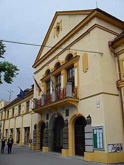
 Town hall | |
Location of Tornaľa in the Banská Bystrica Region | |
| Coordinates: 48°25′20″N 20°19′49″E / 48.42222°N 20.33028°E | |
| Country | Slovakia |
| Region | Banská Bystrica |
| District | Revúca |
| First mentioned | 1245 |
| Government | |
| • Mayor | Erika Győrfi (HLAS-SD Sme Rodina) |
| Area | |
| • Total | 57.70 km2 (22.28 sq mi) |
| (2022) | |
| Elevation | 182[2] m (597[2] ft) |
| Population | |
| • Total | 6,791 |
| • Density | 120/km2 (300/sq mi) |
| Time zone | UTC+1 (CET) |
| • Summer (DST) | UTC+2 (CEST) |
| Postal code | 982 01[2] |
| Area code | +421 47[2] |
| Car plate | RA |
| Website | www.mestotornala.sk |
Tornaľa (formerly Šafárikovo, Hungarian: Tornalja) is a town and municipality in Revúca District in the Banská Bystrica Region of Slovakia, with a population of approximately 7,000.
History
[edit]The first written record of the settlement dates back from 1245. The town was located in the Kingdom of Hungary until the second half of the 19th century. During the periods 1554 - 1593 and 1596 - 1686, Tornaľa was ruled by the Ottoman Empire as part of Filek sanjak with its centre in Rimaszombat). Before the establishment of independent Czechoslovakia in 1918, Tornaľa was part of Gömör and Kishont County within the Kingdom of Hungary. From 1938 to 1944, it was again part of Hungary as a result of the First Vienna Award. On 19 December 1944, Soviet troops of the 2nd Ukrainian Front entered Tornaľa. It became part of Czechoslovakia once again.
Geography
[edit]Tornaľa lies at an altitude of 183 metres (600 ft) above sea level and covers an area of 57.768 square kilometres (22.3 sq mi).[4] It is located in the historical Gemer region and lies on the Slaná river.
Demographics
[edit]| Year | Pop. | ±% |
|---|---|---|
| 1970 | 6,436 | — |
| 1980 | 7,021 | +9.1% |
| 1991 | 8,185 | +16.6% |
| 2001 | 8,169 | −0.2% |
| 2011 | 7,509 | −8.1% |
| 2021 | 6,971 | −7.2% |
| Source: Censuses[5][6] | ||
According to the 2001 census, the town had 8,169 inhabitants. 62.14% of inhabitants were Hungarians, 29.77% Slovaks, 6.70% Roma and 0.50% Czech.[4] Religioun is made up of 49.37% Roman Catholics, 17.03% people with no religious affiliation and 7.33% Lutherans.[4]
Notable people
[edit]- Barna Basilides (1903–1967), Hungarian painter
Twin towns — sister cities
[edit] Heves, Hungary
 Putnok, Hungary
 Tarnów, Poland
 Valea lui Mihai, Romania
References
[edit]- ^ Statistical Office of the Slovak Republic (www.statistics.sk). "Hustota obyvateľstva - obce". www.statistics.sk. Retrieved 2024-02-08.
- ^ a b c d "Základná charakteristika". www.statistics.sk (in Slovak). Statistical Office of the Slovak Republic. 2015-04-17. Retrieved 2022-03-31.
- ^ Statistical Office of the Slovak Republic (www.statistics.sk). "Počet obyvateľov podľa pohlavia - obce (ročne)". www.statistics.sk. Retrieved 2024-02-08.
- ^ a b c "Municipal Statistics". Statistical Office of the Slovak republic. Archived from the original on 2008-01-11. Retrieved 2008-02-01.
- ^ "Statistical lexikon of municipalities 1970-2011" (PDF) (in Slovak).
- ^ "Census 2021 - Population - Basic results". Statistical Office of the Slovak Republic. 2021-01-01.
- ^ "Družobné mestá". mestotornala.sk (in Slovak). Tornaľa. Retrieved 2019-09-09.
External links
[edit]![]() Media related to Tornaľa at Wikimedia Commons
Media related to Tornaľa at Wikimedia Commons
- Official website (in Slovak)


