Steenbergen
Steenbergen | |
|---|---|
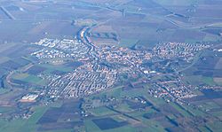
 Aerial view of Steenbergen | |
 Location in North Brabant | |
| Coordinates: 51°35′N 4°19′E / 51.583°N 4.317°E | |
| Country | Netherlands |
| Province | North Brabant |
| Government | |
| • Body | Municipal council |
| • Mayor | Ruud van den Belt (VVD) |
| Area | |
• Total | 159.14 km2 (61.44 sq mi) |
| • Land | 146.43 km2 (56.54 sq mi) |
| • Water | 12.71 km2 (4.91 sq mi) |
| Elevation | 1 m (3 ft) |
| Population (January 2021)[4] | |
• Total | 24,310 |
| • Density | 166/km2 (430/sq mi) |
| Demonym | Steenbergenaar |
| Time zone | UTC+1 (CET) |
| • Summer (DST) | UTC+2 (CEST) |
| Postcode | 4650–4655, 4670–4671, 4680–4681, 4756 |
| Area code | 0167 |
| Website | gemeente-steenbergen |
Steenbergen (Dutch pronunciation: [ˈsteːmbɛrɣə(n)] ) is a municipality and a town in the province of North Brabant in the south of the Netherlands. The municipality had a population of 24,310 in 2021 and covers an area of 159.14 km2 (61.44 sq mi) of which 12.71 km2 (4.91 sq mi) is water. The municipality is mainly agricultural including a strongly growing greenhouse sector, but Steenbergen and the nearby town of Dinteloord also contain some light industry. A new stretch of A4 motorway under construction is expected to further increase the municipality's attractiveness, allowing easy connections with the large cities of Rotterdam to the north and the Belgian city of Antwerp to the south. The connection with the nearby city of Bergen op Zoom will also be improved as a result.
Population centres
[edit]
- Steenbergen (population: 12,440)
- Dinteloord (5,680)
- Nieuw-Vossemeer (2,400)
- Kruisland (2,340)
- Welberg (1,118)
- De Heen (440)
- t'Haantje
The city of Steenbergen
[edit]Steenbergen received city rights in 1272.
Graves of Guy Gibson and Jim Warwick
[edit]
Guy Gibson, Wing Commander and the first CO of the RAF's 617 Squadron which he led in the "Dam Busters" raid in 1943, crashed with his Mosquito aircraft in this municipality. Having returned to operational duties in 1944 after pestering Bomber Command, 26-year-old Gibson was killed along with his navigator, Sqn Ldr Jim Warwick, on a bombing raid on Rheydt (nowadays a borough of Mönchengladbach) operating as a Pathfinder Master Bomber based at RAF Coningsby, when his de Havilland Mosquito XX, KB267, crashed near Steenbergen on 19 September 1944. It was assumed for years that he had been shot down, but following the discovery of the wreckage it was found that a fault with the fuel tank selector possibly meant the aircraft simply ran out of fuel.[5] An eye-witness account detailed how his aircraft circled Steenbergen and heard its engines 'splutter and stop'.[6] In 2011 it was revealed the Mosquito may also have been shot down in a friendly fire incident.[7] The graves are in the RC cemetery of Steenbergen. Streets have been named for both Gibson and Warwick, and one of the aircraft's propellers is located in the city park as a memorial.
Notable people
[edit]
- Johan Arnold Bloys van Treslong (1757 in Steenbergen – 1824) a Dutch naval officer and Patriot
- Jan Maas (1900 in Steenbergen – 1977) a Dutch racing cyclist who competed in the 1924 and the 1928 Summer Olympics
- Niel Steenbergen (1911 in Steenbergen – 1997) a Dutch artist, sculptor, painter and medalist
- Ella Vogelaar (born 1949 in Steenbergen) a retired Dutch politician
- Pierre van Hooijdonk (born 1969 in Steenbergen) a retired Dutch international footballer with 551 club caps
- Eric Hellemons (born 1971 in Kruisland) a Dutch former footballer with 358 club caps and current football coach,
- Nasrdin Dchar (born 1978 in Steenbergen) a Moroccan-Dutch actor and presenter [8]
Gallery
[edit]-
Steenbergen, church: St. Gummaruskerk
-
Front view of the inner harbour of Steenbergen
-
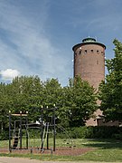
Steenbergen, watertower
-
Northern City Dike, Steenbergen
-
Gibson and Warwick
See also
[edit]References
[edit]- ^ "Belt van den, Ruud" (in Dutch). Gemeente Steenbergen. Retrieved 5 June 2014.
- ^ "Kerncijfers wijken en buurten 2020" [Key figures for neighbourhoods 2020]. StatLine (in Dutch). CBS. 24 July 2020. Retrieved 19 September 2020.
- ^ "Postcodetool for 4652GA". Actueel Hoogtebestand Nederland (in Dutch). Het Waterschapshuis. Retrieved 5 June 2014.
- ^ "Bevolkingsontwikkeling; regio per maand" [Population growth; regions per month]. CBS Statline (in Dutch). CBS. 1 January 2021. Retrieved 2 January 2022.
- ^ "Personal Effects of Guy Gibson on show". mod.uk. Archived from the original on Oct 19, 2012.
- ^ Bomber Barons, Chaz Bowyer (1983) page 165
- ^ After The Battle no. 155 (2012), page 47,
- ^ IMDb Database retrieved 27 August 2019
External links
[edit] Media related to Steenbergen at Wikimedia Commons
- Official website


