Madawaska Valley
Appearance
(Redirected from Sherwood Township, Ontario)
Madawaska Valley | |
|---|---|
| Township of Madawaska Valley | |
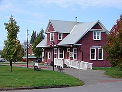
 Tourist office in Barry's Bay | |
| Coordinates: 45°30′N 77°40′W / 45.500°N 77.667°W | |
| Country | Canada |
| Province | Ontario |
| County | Renfrew |
| Formed | January 1, 2001 |
| Government | |
| • Mayor | Mark Willmer |
| • Federal riding | Renfrew—Nipissing—Pembroke |
| • Prov. riding | Renfrew—Nipissing—Pembroke |
| Area | |
| • Land | 665.83 km2 (257.08 sq mi) |
| Population (2021)[1] | |
| • Total | 3,927 |
| • Density | 5.9/km2 (15/sq mi) |
| Time zone | UTC-5 (EST) |
| • Summer (DST) | UTC-4 (EDT) |
| Postal Code | K0J |
| Area code(s) | 613, 343 |
| Website | https://www.madawaskavalley.ca |
The Township of Madawaska Valley is a township municipality in Renfrew County, Ontario, Canada. It was formed in 2001 through the amalgamation of the village of Barry's Bay and the townships of Radcliffe and Sherwood Jones & Burns.
Its largest population centre is Barry's Bay, and it also includes the settlements of Combermere and Wilno.
Demographics
[edit]In the 2021 Census of Population conducted by Statistics Canada, Madawaska Valley had a population of 3,927 living in 1,713 of its 2,541 total private dwellings, a change of -4.8% from its 2016 population of 4,123. With a land area of 665.83 km2 (257.08 sq mi), it had a population density of 5.9/km2 (15.3/sq mi) in 2021.[1]
Canada census – Madawaska Valley community profile
| 2021 | 2016 | 2011 | |
|---|---|---|---|
| Population | 3,927 (-4.8% from 2016) | 4,123 (-3.7% from 2011) | 4,282 (-2.3% from 2006) |
| Land area | 665.83 km2 (257.08 sq mi) | 672.51 km2 (259.66 sq mi) | 671.85 km2 (259.40 sq mi) |
| Population density | 5.9/km2 (15/sq mi) | 6.1/km2 (16/sq mi) | 6.4/km2 (17/sq mi) |
| Median age | 58.4 (M: 57.6, F: 59.2) | 55.5 (M: 54.4, F: 56.4) | 51.3 (M: 49.9, F: 52.3) |
| Private dwellings | 2,541 (total) 1,713 (occupied) | 2,619 (total) 1,706 (occupied) | 2,748 (total) |
| Median household income | $62,800 | $52,679 |
| Year | Pop. | ±% |
|---|---|---|
| 2001 | 4,406 | — |
| 2006 | 4,381 | −0.6% |
| 2011 | 4,282 | −2.3% |
| 2016 | 4,123 | −3.7% |
| 2021 | 3,927 | −4.8% |
| Source: Statistics Canada[1][7] | ||
- Population total in 1996:
- Barry's Bay: 1,086
- Radcliffe township: 1,116
- Sherwood, Jones and Burns township: 2,140
- Population in 1991:
- Barry's Bay: 1,088
- Radcliffe township: 1,077
- Sherwood, Jones and Burns township: 2,101
Mother tongue (2021):[1]
- English as first language: 84.2%
- French as first language: 2.2%
- English and French as first language: 0.5%
- Other as first language: 11.4%
Local government
[edit]List of former mayors:
- William "Bill" Schweig (2001–2003)
- John Hildebrandt
- David Shulist
- Kim Love (2014–2022)
- Mark Willmer (2022–present)
References
[edit]- ^ a b c d e "Madawaska Valley (Code 3547030) Census Profile". 2021 census. Government of Canada - Statistics Canada. Retrieved 2024-07-31.
- ^ "2021 Community Profiles". 2021 Canadian census. Statistics Canada. February 4, 2022. Retrieved 2023-10-19.
- ^ "2016 Community Profiles". 2016 Canadian census. Statistics Canada. August 12, 2021. Retrieved 2018-02-19.
- ^ "2011 Community Profiles". 2011 Canadian census. Statistics Canada. March 21, 2019. Retrieved 2012-02-13.
- ^ "2006 Community Profiles". 2006 Canadian census. Statistics Canada. August 20, 2019.
- ^ "2001 Community Profiles". 2001 Canadian census. Statistics Canada. July 18, 2021.
- ^ 1996, 2001, 2006, 2011, 2016 census
External links
[edit]Wikimedia Commons has media related to Madawaska Valley.


