Xai-Xai
Xai-Xai
João Belo | |
|---|---|
 Municipal Council of Xai-Xai | |
| Coordinates: 25°03′00″S 33°39′00″E / 25.05000°S 33.65000°E | |
| Country | |
| Provinces | Gaza Province |
| District | Xai-Xai District |
| Elevation | 9 m (30 ft) |
| Population (2007)[1] | |
• Total | 116,343 |
| • Languages | Portuguese Tsonga |
| Time zone | +2 |
| Climate | Aw |
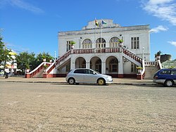
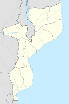
Xai-Xai (Portuguese pronunciation: [ˈʃaj ˈʃaj]) is a city in the south of Mozambique. Until 1975, the city was named João Belo. It is the capital of Gaza Province. As of 2007 it has a population of 116,343.[1]
History
[edit]Portuguese rule
[edit]Xai-Xai, formerly João Belo, developed in the early 1900s, under Portuguese rule, as a companion port to Lourenço Marques (now Maputo), though its economic significance was never on par with Mozambique's largest city.[2] Before independence from Portugal in 1975, Xai-Xai was known as João Belo, in the Overseas Province of Mozambique.[3] João Belo grew and developed under Portuguese rule as a port, agricultural and industrial centre (rice and cashew were harvested and processed), a provider of services, including a district hospital and banking, and an administrative centre. Tourism was also important with beaches and hotels.[4] In 1970, the city had 63,949 inhabitants.
Post-independence from Portugal
[edit]It was hit hard by the 2000 Limpopo floods, caused by four weeks of heavy rainfall accompanying Cyclone Leon-Eline, leaving some buildings 3 metres (10 ft) under water.[5] However, shortly after the waters receded the town was opened for business again.[5]
Geography
[edit]At an elevation of 9.8 m (32 ft),[3] Xai-Xai is located on the Limpopo River, close to the Indian Ocean,[6] and in a wide, fertile plain where rice is grown.[6] It is 200 kilometres (120 mi) from the capital, Maputo, and is 5.2 km (3+1⁄4 mi) from Donguene, 4.0 km (2+1⁄2 mi) from Macandene, 2.8 km (1+3⁄4 mi) from Chiluane and 800 m (1⁄2 mi) from Tavene.[3]
Climate
[edit]Xai-Xai has a tropical savanna climate (Köppen climate classification Aw).
| Climate data for Xai-Xai (1961–1990) | |||||||||||||
|---|---|---|---|---|---|---|---|---|---|---|---|---|---|
| Month | Jan | Feb | Mar | Apr | May | Jun | Jul | Aug | Sep | Oct | Nov | Dec | Year |
| Mean daily maximum °C (°F) | 31.2 (88.2) |
30.9 (87.6) |
30.2 (86.4) |
28.9 (84.0) |
27.0 (80.6) |
25.0 (77.0) |
24.9 (76.8) |
26.3 (79.3) |
27.7 (81.9) |
29.1 (84.4) |
30.0 (86.0) |
30.9 (87.6) |
28.5 (83.3) |
| Mean daily minimum °C (°F) | 21.7 (71.1) |
21.9 (71.4) |
20.9 (69.6) |
18.4 (65.1) |
15.3 (59.5) |
12.6 (54.7) |
12.1 (53.8) |
13.6 (56.5) |
15.7 (60.3) |
17.6 (63.7) |
19.4 (66.9) |
20.8 (69.4) |
17.5 (63.5) |
| Average rainfall mm (inches) | 134.7 (5.30) |
131.9 (5.19) |
104.5 (4.11) |
99.0 (3.90) |
89.0 (3.50) |
63.9 (2.52) |
49.6 (1.95) |
32.8 (1.29) |
33.6 (1.32) |
66.3 (2.61) |
71.6 (2.82) |
123.2 (4.85) |
1,000.1 (39.36) |
| Average rainy days | 9.1 | 8.8 | 7.5 | 6.9 | 6.6 | 5.6 | 4.0 | 3.3 | 5.5 | 6.0 | 6.8 | 8.9 | 79 |
| Source: World Meteorological Organization[7] | |||||||||||||
Attractions
[edit]Xai-Xai is a bustling town with markets, shops, restaurants, bars, petrol stations, banks, and a post office.[6] A few blocks from the central market, there is an open-air furniture factory, located underneath several cashew trees.[8] Xai-Xai Beach, approximately 12 km from Xai-Xai, has been a popular tourist attraction since Mozambican tourism, originally under Portuguese administration, was first developed before 1975.[6] A coral reef running parallel to the shore offers good snorkeling and protects the beach from strong waves.[6] In addition, the Wenela Tidal Pool, two kilometres (1+1⁄4 mi) south of the town, includes a natural tunnel and blow hole that links the pool to the Indian Ocean.[6] Right on Xai-Xai Beach there is a giant rock pool that forms at medium and low tides that is up to 200 metres long, forming a giant safe pool for families and swimmers.[9]
Demographics
[edit]| Year | Population[1] |
|---|---|
| 1970 | 63,949 |
| 1997 | 103,251 |
| 2007 | 116,343 |
Transport
[edit]Xai-Xai was served by the 762 mm (2 ft 6 in) gauge Gaza Railway, which went to the city of Manjacaze and beyond. It lies on the EN1 road which connects with the roads from the Namaacha and Ressano Garcia borders.[6] It is possible to travel to Xai-Xai by charter flight from Maputo.[6]
In 2017, the People's Republic of China pledged $60 million to build an airport in Xai-Xai.[10]
That airport was inaugurated in 2021[11] and is served by one airline, LAM Mozambique.
Gallery
[edit]-
Xai-Xai train station
-
Prawns at Xai-Xai market
Sister city
[edit]See also
[edit]References
[edit]- ^ a b c "Mozambique: largest cities and towns and statistics of their population". World Gazetteer. Retrieved 2008-06-17.[dead link]
- ^ Fitzpatrick, Mary (2007). Lonely Planet Mozambique. Lonely Planet. p. 82. ISBN 978-1-74059-188-1.
- ^ a b c "Maps, Weather, and Airports for Xai-Xai, Mozambique". FallingRain Genomics. Retrieved 2008-06-17.
- ^ JOÃO BELO-XAI-XAI, a film of João Belo, Portuguese Mozambique, before 1975.
- ^ a b "Gaza Province » Cities and towns » Xai-Xai". go2africa.com. Retrieved 2008-06-17.
- ^ a b c d e f g h "Xai Xai". Southern Africa Places. Retrieved 2008-06-17.
- ^ "World Weather Information Service". World Meteorological Organization. Retrieved 18 August 2024.
- ^ "Xai Xai Accommodation and things to do". Mozambique Connection. Archived from the original on March 31, 2007. Retrieved 2008-06-17.
- ^ "Xai Xai Hotels and information". Retrieved 2017-01-15.
- ^ Tebele, Mpho (December 15, 2017). "China to finance Xai-Xai airport in Mozambique". The Southern Times. Retrieved December 19, 2017.
The Chinese government has pledged to grant $60 million to Mozambique to build an airport at Xai-Xai, capital of the southern province of Gaza.
- ^ "Mozambique's President inaugurates newly Completed Chongoene Airport, Praises China's role in Africa's Growth". 3 December 2021.


