Qods County
Qods County
Persian: شهرستان قدس | |
|---|---|
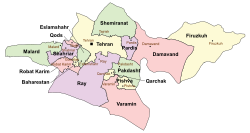
 Location of Qods County in Tehran province (top left, pink) | |
 Location of Tehran province in Iran | |
| Coordinates: 35°42′03″N 51°06′23″E / 35.70083°N 51.10639°E[1] | |
| Country | |
| Province | Tehran |
| Capital | Qods |
| Districts | Central |
| Area | |
| • Total | 81.2 km2 (31.4 sq mi) |
| Population (2016)[2] | |
| • Total | 316,636 |
| • Density | 3,900/km2 (10,000/sq mi) |
| Time zone | UTC+3:30 (IRST) |
Qods County (Persian: شهرستان قدس) is in Tehran province, Iran. Its capital is the city of Qods.[3]
History
[edit]In 2009, Qods District was separated from Shahriar County in the establishment of Qods County, which was divided into one district of two rural districts, with Qods as its capital and only city.[3]
Demographics
[edit]Population
[edit]At the time of the 2011 National Census, the county's population was 290,663 people in 85,169 households.[4] The 2016 census measured the population of the county as 316,636 in 96,682 households.[2]
Administrative divisions
[edit]Qods County's population history and administrative structure over two consecutive censuses are shown in the following table.
| Administrative Divisions | 2011[4] | 2016[2] |
|---|---|---|
| Central District | 290,663 | 316,631 |
| Danesh RD | 4,357 | 3,889 |
| Haft Juy RD | 2,789 | 3,137 |
| Qods (city) | 283,517 | 309,605 |
| Total | 290,663 | 316,636 |
| RD = Rural District | ||
Climate
[edit]According to the information of the State Meteorological Organization of Tehran province, the long-term average annual rainfall of Qods is around 246.1 mm[5]
See also
[edit]![]() Media related to Qods County at Wikimedia Commons
Media related to Qods County at Wikimedia Commons
References
[edit]- ^ OpenStreetMap contributors (21 September 2024). "Qods County" (Map). OpenStreetMap (in Persian). Retrieved 21 September 2024.
- ^ a b c Census of the Islamic Republic of Iran, 1395 (2016): Tehran Province. amar.org.ir (Report) (in Persian). The Statistical Center of Iran. Archived from the original (Excel) on 12 December 2021. Retrieved 19 December 2022.
- ^ a b Davodi, Parviz (22 April 2009). "The government's agreement with 18 changes in national divisions: Three counties were added to the geographical map of the country". dolat.ir (in Persian). Ministry of the Interior, Board of Ministers. Archived from the original on 5 February 2018. Retrieved 22 November 2023 – via Secretariat of the Government Information Council.
- ^ a b Census of the Islamic Republic of Iran, 1390 (2011): Tehran Province. irandataportal.syr.edu (Report) (in Persian). The Statistical Center of Iran. Archived from the original (Excel) on 20 January 2023. Retrieved 19 December 2022 – via Iran Data Portal, Syracuse University.
- ^ https://tehranmet.ir/uploads/tahghighat/140201.pdf [bare URL PDF]

