Serebryany Bor (park)
Appearance
(Redirected from Serebryannyi Bor)
This article relies largely or entirely on a single source. (April 2019) |
You can help expand this article with text translated from the corresponding article in Russian. (February 2018) Click [show] for important translation instructions.
|
| Serebryany Bor | |
|---|---|
| Серебряный Бор | |
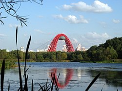
 Serebryany Bor with a view of the Zhivopisny Bridge, 2008 | |
 Location in Moscow | |
| Location | Moscow, Russia |
| Coordinates | 55°46′50″N 37°24′58″E / 55.78056°N 37.41611°E |
| Area | 328.6 hectares[1] |
| Created | October 17, 1991 |
| Public transit access | |
Serebryany Bor (Russian: Серебряный Бор, literally "Silver Pinewood") is a large forest park in north-west Moscow. The park is a natural monument of regional significance and a protected area of the city of Moscow. It poses an artificial island that was formed during the creation of the Khoroshevskoye spryamlenie canal ("Khoroshevsky cutoff" canal).[2] Serebryany Bor covers an area of 328.6 hectares.[1]
It is also a concentration of luxury real estate owned by wealthy businessmen and government officials.[3]
References
[edit]- ^ a b "Серебряный бор". oopt.aari.ru (in Russian). n.d. Retrieved April 28, 2019.
- ^ "Памятник природы "Серебряный Бор"". Проект «Московские Парки: фотосайт-путеводитель» (in Russian). March 4, 2015. Retrieved April 4, 2019.
- ^ "Russia Accidentally Reveals Addresses of Putin's Secret Service". Newsweek.
