Saint-Rémy-de-Provence
Saint-Rémy-de-Provence
Sant Romieg de Provença (Occitan) | |
|---|---|
 Roman site 'Les Antiques' of Glanum, with the Mausoleum (left) and the Arch (right) | |
| Coordinates: 43°47′24″N 4°49′57″E / 43.79°N 4.8325°E | |
| Country | France |
| Region | Provence-Alpes-Côte d'Azur |
| Department | Bouches-du-Rhône |
| Arrondissement | Arles |
| Canton | Salon-de-Provence-1 |
| Intercommunality | Vallée des Baux-Alpilles |
| Government | |
| • Mayor (2022–2026) | Hervé Chérubini[1] |
Area 1 | 89.09 km2 (34.40 sq mi) |
| Population (2021)[2] | 9,619 |
| • Density | 110/km2 (280/sq mi) |
| Time zone | UTC+01:00 (CET) |
| • Summer (DST) | UTC+02:00 (CEST) |
| INSEE/Postal code | 13100 /13210 |
| Elevation | 7–392 m (23–1,286 ft) (avg. 60 m or 200 ft) |
| 1 French Land Register data, which excludes lakes, ponds, glaciers > 1 km2 (0.386 sq mi or 247 acres) and river estuaries. | |
Saint-Rémy-de-Provence (French pronunciation: [sɛ̃ ʁemi də pʁɔvɑ̃s]; lit. "Saint-Rémy of Provence"; Provençal: Sant Romieg de Provença (classical norm) and Sant Roumié de Prouvènço (Mistralian norm)) is a commune in the Bouches-du-Rhône department in the Provence-Alpes-Côte d'Azur region in Southern France.[3] It is often referred to simply as Saint-Rémy, its official name until 12 April 1953.[4] Located in the northern part of the Alpilles, of which it is the main town, it had a population of 9,692 as of 2020.
History
[edit]The town, which has been inhabited since prehistory, was named after Saint Remigius under the Latin name Villa Sancti Remigii.
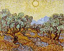
From May 1889 to May 1890, Vincent van Gogh was a patient at the Saint-Paul Asylum in Saint-Rémy-de-Provence, and painted some of his most memorable works, including The Starry Night, which features the town.
-
Olive Trees with yellow sky and sun, 1889
-
Olive Trees with the Alpilles in the Background, 1889
-
Irises, 1889
-
The Starry Night, 1889
-
Landscape with Trees and Figures, 1889
Geography
[edit]
Saint-Rémy-de-Provence is situated about 20 km (12 mi) south of Avignon, just north of the Alpilles mountain range.
Transportation
[edit]The Avignon TGV high-speed train station is 20 km (12 mi) from the city. The closest airports are serving the cities of Avignon, Nîmes and Marseille.
Also, there are several highways and main roads which serve Saint-Rémy. The A7 autoroute, which runs down the Valley of the Rhône and connects Lyon to Marseille via Orange, is about 12 km (7.5 mi) east of Saint-Rémy. The A54 autoroute runs from Nîmes to Salon-de-Provence, passing through Arles, 17 km (11 mi) away. Finally, the A9 autoroute is 20 km to the northwest and runs from Orange to Perpignan via Montpellier.
Climate
[edit]The climate in the Alpilles is considered Mediterranean. Winters there are gentle and dry, and summers are hot and dry. The highest average temperature is recorded in July and August 29 °C (84 °F), and the lowest in December and January 3 °C (37 °F). The rainiest month is January with an average of 7 rainy days, compared with July, the driest month, with an average of 2 rainy days. The Alpilles region receives more precipitation than the French Rivera, 1–2 cm more per year. There are about 30 days of frost per year. Snow is rare, but can be heavy when it does fall.
Demographics
[edit]
|
| ||||||||||||||||||||||||||||||||||||||||||||||||||||||||||||||||||||||||||||||||||||||||||||||||||||||||||||||||||
| Source: EHESS[5] and INSEE (1968–2017)[6] | |||||||||||||||||||||||||||||||||||||||||||||||||||||||||||||||||||||||||||||||||||||||||||||||||||||||||||||||||||
Sights
[edit]
The ruins of the Roman city of Glanum, including a triumphal arch, can still be seen on the southern outskirts of the city.
The Saint-Paul Asylum in Saint-Rémy-de-Provence is where Vincent van Gogh was a patient, from May 1889 to May 1890, and where he painted some of his most memorable works, including The Starry Night which features the town. The site is now named the Clinique Van Gogh for him.[7]
Notable people
[edit]- Pierre Daboval (1918–2015), artist, lived for many years in Saint-Rémy-de-Provence
- Marie Gasquet, a Provençale novelist and queen of the Felibrige
- Vincent van Gogh, from May 1889 to May 1890, the famous Dutch painter was admitted to the Saint-Paul psychiatric hospital in Saint-Remy-de-Provence. He painted several paintings, including Starry Night.
- Louis-Thomas Chabert de Joncaire, (1670–1739), French army officer and interpreter in New France
- Princess Caroline of Monaco and her children lived in Saint-Rémy for several years following the death of her second husband, Stefano Casiraghi
- Pablo Daniel Magee, writer, journalist and playwright grew up in Saint-Rémy-de-Provence
- Nostradamus, a 16th-century author of prophecies
See also
[edit]References
[edit]- ^ "Répertoire national des élus: les maires" (in French). data.gouv.fr, Plateforme ouverte des données publiques françaises. 4 May 2022.
- ^ "Populations légales 2021" (in French). The National Institute of Statistics and Economic Studies. 28 December 2023.
- ^ Commune de Saint-Rémy-de-Provence (13100), INSEE. (in French)
- ^ Décret du 8 avril 1953 portant changement de nom de la commune de Saint-Rémy (Bouches-du-Rhône), Journal officiel de la République française n° 0086, 11 April 1953, p. 3405.
- ^ Des villages de Cassini aux communes d'aujourd'hui: Commune data sheet Saint-Rémy-de-Provence, EHESS (in French).
- ^ Population en historique depuis 1968, INSEE.
- ^ Kennedy, Maev. "Van Gogh's 'terrifying environment' of French asylum revealed". The Guardian. No. 25 August 2018. Guardian News & Media Limited. Retrieved 21 October 2020.


