Saint-Majorique-de-Grantham
Saint-Majorique-de-Grantham | |
|---|---|
 | |
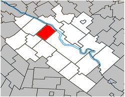
 Location within Drummond RCM. | |
| Coordinates: 45°56′N 72°35′W / 45.933°N 72.583°W[1] | |
| Country | |
| Province | |
| Region | Centre-du-Québec |
| RCM | Drummond |
| Constituted | July 13, 1901 |
| Government | |
| • Mayor | Line Fréchette |
| • Federal riding | Drummond |
| • Prov. riding | Johnson |
| Area | |
• Total | 58.80 km2 (22.70 sq mi) |
| • Land | 57.50 km2 (22.20 sq mi) |
| Population | |
• Total | 1,384 |
| • Density | 24.1/km2 (62/sq mi) |
| • Pop 2016-2021 | |
| • Dwellings | 536 |
| Time zone | UTC−5 (EST) |
| • Summer (DST) | UTC−4 (EDT) |
| Postal code(s) | |
| Area code | 819 |
| Highways | |
| Website | www.st-majorique degrantham.qc.ca |
Saint-Majorique-de-Grantham is a parish municipality in the Centre-du-Québec region of Quebec. The population as of the Canada 2021 Census was 1,384.
The name Saint-Majorique-de-Grantham was chosen in honor of father Majorique-Pierre Marchand who was put in charge of a commission to verify the merits of the residents request to have their own parish separated from the rest of Grantham. The Grantham section was put to emphasize the fact that it was formerly a section of that municipality.
Geography
[edit]The Saint-François River forms the north-eastern boundary of the municipality, flowing south-westwards. The Rivière aux Vaches, a tributary of the Saint-François River, crosses the municipality from south to north, passing to the west of the town.
Demographics
[edit]In the 2021 Census of Population conducted by Statistics Canada, Saint-Majorique-de-Grantham had a population of 1,384 living in 524 of its 536 total private dwellings, a change of -0.3% from its 2016 population of 1,388. With a land area of 57.5 km2 (22.2 sq mi), it had a population density of 24.1/km2 (62.3/sq mi) in 2021.[5]
Population trend:[6]
| Census | Population | Change (%) |
|---|---|---|
| 2021 | 1,384 | |
| 2016 | 1,388 | |
| 2011 | 1,251 | |
| 2006 | 1,136 | |
| 2001 | 952 | |
| 1996 | 871 | |
| 1991 | 872 | |
| 1986 | 865 | |
| 1981 | 851 | |
| 1976 | 759 | |
| 1971 | 656 | |
| 1966 | 607 | |
| 1961 | 589 | |
| 1956 | 590 | |
| 1951 | 562 | |
| 1941 | 579 | |
| 1931 | 560 | |
| 1921 | 570 | |
| 1911 | 597 | N/A |
Mother tongue language (2021)[7]
| Language | Population | Pct (%) |
|---|---|---|
| French only | 1,355 | 98.2% |
| English only | 10 | 0.7% |
| Both English and French | 5 | 0.4% |
| Other languages | 10 | 0.7% |
See also
[edit]References
[edit]- ^ "Banque de noms de lieux du Québec: Reference number 57158". toponymie.gouv.qc.ca (in French). Commission de toponymie du Québec.
- ^ a b Ministère des Affaires municipales, des Régions et de l'Occupation du territoire: Saint-Majorique-de-Grantham
- ^ Parliament of Canada Federal Riding History: DRUMMOND (Quebec)
- ^ a b 2021 Statistics Canada Census Profile: Saint-Majorique-de-Grantham, Quebec
- ^ "Population and dwelling counts: Canada, provinces and territories, and census subdivisions (municipalities), Quebec". Statistics Canada. February 9, 2022. Retrieved August 29, 2022.
- ^ Statistics Canada: 1996, 2001, 2006, 2011, 2016, 2021 census
- ^ https://www12.statcan.gc.ca/census-recensement/2021/dp-pd/prof/details/page.cfm?LANG=E&GENDERlist=1&STATISTIClist=1,4&DGUIDlist=2021A00052449095&HEADERlist=0&SearchText=Saint-Majorique-de-Grantham 2021 Statistics Canada Community Profile: Saint-Majorique-de-Grantham, Quebec]

