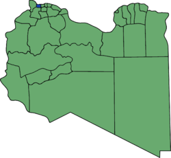
Sabratha wa Sorman District
Appearance
(Redirected from Sabratha Wa Surman District)

Sabratha wa Surman (Sabratha and Surman) was one of the districts of Libya from 1998 to 2007, in the Northwest. Since 2007 the area has been part of Zawiya District.[1]
In the north, Sabratha wa Surman had a shoreline on the Mediterranean Sea. On land, it bordered the following districts:
- Zawiya - east
- Jafara - southeast, at a quadripoint
- Yafran - south
- Nuqat al Khams - west
Notes
[edit]- ^ شعبيات الجماهيرية العظمى – Sha'biyat of Great Jamahiriya Archived 2009-02-07 at the Wayback Machine, accessed 6 September 2009, in Arabic
