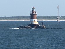
Romer Shoal Light
 | |
 | |
| Location | South of Ambrose Channel, New York Harbor |
|---|---|
| Coordinates | 40°30′46.823″N 74°0′48.672″W / 40.51300639°N 74.01352000°W |
| Tower | |
| Constructed | 1838 |
| Foundation | Concrete / cast iron caisson |
| Construction | Cast iron |
| Automated | 1966 |
| Height | 54 feet (16 m) |
| Shape | Frustum of a cone -- sparkplug |
| Markings | White bottom, red top including lantern |
| Heritage | National Register of Historic Places listed place |
| Fog signal | Horn: 2 every 30 s |
| Light | |
| First lit | 1898 (current tower) |
| Focal height | 54 feet (16 m) |
| Lens | Fourth-order Fresnel lens (original), 7.5 inches (190 mm) (current) |
| Range | 15 nautical miles (28 km; 17 mi) |
| Characteristic | Flashing white twice 15 s |
Romer Shoal Light Station | |
| Nearest city | Highlands, New Jersey |
| Area | less than one acre |
| Built | 1898 |
| Architect | U.S. Lighthouse Board |
| MPS | Light Stations of the United States MPS |
| NRHP reference No. | 06001304[1] |
| NJRHP No. | 3713[2] |
| Significant dates | |
| Added to NRHP | January 24, 2007 |
| Designated NJRHP | August 16, 2006 |
Romer Shoal Light is a sparkplug lighthouse in Lower New York Bay, on the north edge of the Swash Channel, about 3⁄4 nautical mile (1.4 km; 0.86 mi) south of Ambrose Channel and 2+1⁄2 nautical miles (4.6 km; 2.9 mi) north of Sandy Hook, New Jersey, in the entrance to New York Harbor.[3][4][5][6] It is in New Jersey, very close to the border with New York.[7] Named as Romer Shoal Light Station, it was added to the National Register of Historic Places on January 24, 2007, for its significance in architecture, engineering, transportation, and maritime history.[8]
History and description
[edit]An 1870 edition of The Historical Magazine records that the shoal was named after Colonel Wolfgang William Romer, who sounded the waters of New York Bay in 1700 on order of the governor of New York. https://www.lighthousefriends.com/light.asp?ID=655
The Light was heavily damaged during Hurricane Sandy. The non-profit that has taken over stewardship of the Light is working with FEMA and private donors to preserve this national landmark.
See also
[edit]References
[edit]- ^ "National Register Information System – (#06001304)". National Register of Historic Places. National Park Service. November 2, 2013.
- ^ "New Jersey and National Registers of Historic Places – Monmouth County" (PDF). New Jersey Department of Environmental Protection - Historic Preservation Office. July 15, 2022. p. 6.
- ^ "Historic Light Station Information and Photography: New Jersey". United States Coast Guard Historian's Office. Archived from the original on 2017-05-01.
- ^ Light List, Volume I, Atlantic Coast, St. Croix River, Maine to Shrewsbury River, New Jersey (PDF). Light List. United States Coast Guard. 2009. p. 204.
- ^ Rowlett, Russ. "Lighthouses of the United States: New Jersey". The Lighthouse Directory. University of North Carolina at Chapel Hill.
- ^ NOAA Chart #12327 New York Harbor 1/40,000 2006
- ^ USGS quadrangle for cited location
- ^ Koski-Karell, Daniel (August 2006). "National Register of Historic Places Inventory/Nomination: Romer Shoal Light Station". National Park Service. With accompanying 7 photos
External links
[edit]- Lighthouses completed in 1898
- Transportation buildings and structures in Monmouth County, New Jersey
- Lighthouses on the National Register of Historic Places in New Jersey
- National Register of Historic Places in Monmouth County, New Jersey
- New Jersey Register of Historic Places
- 1898 establishments in New Jersey

