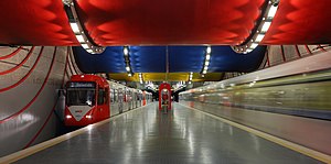
Rochusplatz station
Appearance
(Redirected from Rochusplatz)
Rochusplatz | ||||||||||||||||
|---|---|---|---|---|---|---|---|---|---|---|---|---|---|---|---|---|
 Äußere Kanalstraße station | ||||||||||||||||
| General information | ||||||||||||||||
| Location | Venloer Straße, 50825 Köln | |||||||||||||||
| Coordinates | 50°57′24″N 06°54′11″E / 50.95667°N 6.90306°E | |||||||||||||||
| Owned by | Kölner Verkehrs-Betriebe | |||||||||||||||
| Platforms | 1 island platform | |||||||||||||||
| Connections | Bus, Taxi | |||||||||||||||
| Construction | ||||||||||||||||
| Structure type | Underground | |||||||||||||||
| Bicycle facilities | Call a Bike | |||||||||||||||
| Accessible | Yes | |||||||||||||||
| Other information | ||||||||||||||||
| Fare zone | VRS: 2100[1] | |||||||||||||||
| History | ||||||||||||||||
| Opened | 1992 | |||||||||||||||
| Services | ||||||||||||||||
| ||||||||||||||||
| ||||||||||||||||
| ||||||||||||||||
Rochusplatz is an underground station on the Cologne Stadtbahn lines 3 and 4 in Cologne. The station is located on Venloer Straße at its intersection with Äußere Kanalstraße in the district of Ehrenfeld.[2]
The station was opened in 1992 and consists of a mezzanine and one island platform with two rail tracks.[citation needed]
The station was renamed on 15 December 2019 from Äußere Kanalstraße to Rochusplatz.[3]
See also
[edit]References
[edit]- ^ "VRS-Gemeinschaftstarif" (PDF) (in German). Verkehrsverbund Rhein-Sieg. 20 April 2020. p. 202. Retrieved 9 May 2020.
- ^ Ltd, rome2rio Pty. "Düsseldorf central station to Rochusplatz (KVB) - 3 ways to travel via , and car". Rome2rio. Retrieved 24 December 2022.
{{cite web}}: CS1 maint: numeric names: authors list (link) - ^ "Fahrplanwechsel". Kölner Verkehrs-Betriebe. Retrieved 15 December 2019.
External links
[edit] Media related to U-Bahnhof Rochusplatz at Wikimedia Commons
- station info page (in German)
- station layout map (in German)
- Rochusplatz station at Structurae


