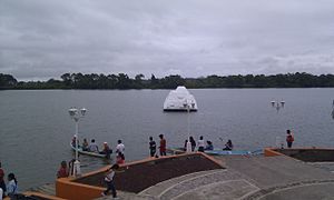
Tecolutla River
| Tecolutla River | |
|---|---|
 The Tecolutla River at Gutiérrez Zamora | |
 | |
| Etymology | Classical Nahuatl: tecolotl, "owl" + lan, "place" |
| Native name | Río Tecolutla (Spanish) |
| Location | |
| Country | Mexico |
| State | Veracruz |
| City | Gutiérrez Zamora |
| Physical characteristics | |
| Source | Confluence of the Necaxa and Apulco Rivers |
| • location | Espinal, Veracruz, Mexico |
| • coordinates | 20°14′31″N 97°26′20″W / 20.242°N 97.439°W |
| Mouth | Gulf of Mexico |
• location | Tecolutla, Veracruz, Mexico |
• coordinates | 20°28′30″N 97°00′00″W / 20.475°N 97.000°W |
| Length | 375 km (233 mi)[1][a] |
| Basin size | 7,903 km2 (3,051 sq mi)[1] |
| |
The Tecolutla River is a river in the state of Veracruz in Mexico, and the main drainage of the historical and cultural region of Totonacapan.[2] It is principally fed by four rivers that rise in the Sierra Norte de Puebla: from north to south, they are the Necaxa, the Lajajalpan (or Laxaxalpan), the Tecuantepec and the Apulco.[3] These rivers converge in the municipality of Espinal, Veracruz, and from here the Tecolutla flows about 100 kilometres (62 mi) east through the coastal plain and the municipalities of Papantla and Gutiérrez Zamora to its mouth at the town of Tecolutla on the Gulf of Mexico,[4] On its south bank the Tecolutla receives the Joloapan River near Paso del Correo, and the Chichicatzapan River via the Ostiones estuary near its mouth.[3]
The furthest source of the Tecolutla is the Arroyo Zapata, located 20 kilometres (12 mi) north of Huamantla, Tlaxcala at an elevation of 3,500 metres (11,500 ft). This arroyo flows into the Coyuca River, which in turn drains into the Apulco.[3] The total length of the river measured from this source is 375 kilometres (233 mi).[1] The watershed drained by the Tecolutla covers an area of 7,903 square kilometres (3,051 sq mi) and has a mean natural surface runoff of 6,098 hm3 (2.153×10¹¹ cu ft) per year.[1]
The first important hydroelectric facilities in Mexico were built in the Tecolutla watershed on the Necaxa River.[3] Nevertheless, the Tecolutla is considered one of the most well-preserved rivers in the state of Veracruz and its floodplains are agriculturally productive.[5] Vanilla may have been first cultivated by the Totonac in this area and has been an important part of their culture for centuries.[6]
References
[edit]- ^ a b c d Ministry of Environment and Natural Resources, ed. (December 2015). Statistics on Water in Mexico, 2015 edition (PDF). National Water Commission in Mexico (CONAGUA). p. 51. Retrieved 6 January 2017.
- ^ Valderrama Rouy, Pablo (2005). "The Totonac". Native Peoples of the Gulf Coast of Mexico. University of Arizona Press. p. 187. ISBN 0816524114.
- ^ a b c d "Hidrología" (PDF). Atlas del patrimonio natural, histórico y cultural de Veracruz (in Spanish). Vol. 1. Government of Veracruz. 2010. pp. 97–98.
- ^ Kourí, Emilio (2004). A Pueblo Divided: Business, Property, and Community in Papantla, Mexico. Stanford University Press. p. 37. ISBN 0804739390.
- ^ "76. RÍO TECOLUTLA". Regiones hidrológicas prioritarias (in Spanish). Mexico: Comisión Nacional para el Conocimiento y Uso de la Biodiversidad. 19 December 2008. Retrieved 27 July 2016.
- ^ Odoux, Eric; Grisoni, Michel, eds. (2011). Vanilla. USA: CRC Press. pp. 252, 335. ISBN 978-1-4200-8337-8.
