Ridgeville Corners, Ohio
Ridgeville Corners, Ohio | |
|---|---|
 Tree-lined street southwest of the post office | |
 Location of Ridgeville Corners, Ohio | |
| Coordinates: 41°26′23″N 84°15′05″W / 41.43972°N 84.25139°W | |
| Country | United States |
| State | Ohio |
| County | Henry |
| Township | Ridgeville |
| Area | |
| • Total | 0.91 sq mi (2.37 km2) |
| • Land | 0.91 sq mi (2.37 km2) |
| • Water | 0.00 sq mi (0.00 km2) |
| Elevation | 738 ft (225 m) |
| Population (2020) | |
| • Total | 416 |
| • Density | 455.14/sq mi (175.65/km2) |
| Time zone | UTC-5 (Eastern (EST)) |
| • Summer (DST) | UTC-4 (EDT) |
| ZIP code | 43555 |
| Area code | 419 |
| FIPS code | 39-67104[3] |
| GNIS feature ID | 2628960[2] |
Ridgeville Corners is an unincorporated community and census-designated place (CDP) in southern Ridgeville Township, Henry County, Ohio, United States. The population was 416 at the 2020 census.
History
[edit]Ridgeville Corners was laid out at an unknown date as an early trading point of Ridgeville Township.[4] The First Congregational Church in Ridgeville Corners was a stop on the Underground Railroad in the mid-1800s.[5] A post office has been in operation at Ridgeville Corners since 1841.[6]
Geography
[edit]Ridgeville Corners is located along U.S. Route 6, approximately 7 miles (11 km) northwest of Napoleon, the Henry county seat. It is located 16 miles (26 km) southeast of Bryan.
According to the United States Census Bureau, the CDP has an area of 0.93 square miles (2.4 km2), all of it recorded as land.[3] As its name suggests,[7] Ridgeville Corners sits on high ground, with the northwest side draining towards the Tiffin River, a south-flowing tributary of the Maumee River, and the southeast side of the community draining directly to the Maumee.
Demographics
[edit]| Census | Pop. | Note | %± |
|---|---|---|---|
| 2020 | 416 | — | |
| U.S. Decennial Census[8] | |||
Gallery
[edit]-
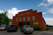
Giffey Hall, built in 1916, now the Archbold Community Theater
-
The intersection of U.S. Route 6 and County Road X. Site of the Ottes building, 1916, now home to the Ridgeville Corners Post Office and local businesses.
References
[edit]- ^ "ArcGIS REST Services Directory". United States Census Bureau. Retrieved September 20, 2022.
- ^ a b U.S. Geological Survey Geographic Names Information System: Ridgeville Corners, Ohio
- ^ a b "Geographic Identifiers: 2010 Census Summary File 1 (G001): Ridgeville Corners CDP, Ohio". American Factfinder. U.S. Census Bureau. Archived from the original on February 13, 2020. Retrieved January 2, 2018.
- ^ Aldrich, Lewis Cass (1888). History of Henry and Fulton Counties, Ohio. D. Mason & Company. p. 274.
- ^ "First Congregational Church".
- ^ "Henry County". Jim Forte Postal History. Retrieved December 12, 2015.
- ^ Overman, William Daniel (1958). Ohio Town Names. Akron, OH: Atlantic Press. p. 118.
- ^ "Census of Population and Housing". Census.gov. Retrieved June 4, 2016.


