Rural Municipality of Reciprocity No. 32
Reciprocity No. 32 | |
|---|---|
| Rural Municipality of Reciprocity No. 32 | |
 St. Raphael Church in Cantal | |
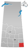
 Location of the RM of Reciprocity No. 32 in Saskatchewan | |
| Coordinates: 49°24′47″N 101°52′23″W / 49.413°N 101.873°W[1] | |
| Country | Canada |
| Province | Saskatchewan |
| Census division | 1 |
| SARM division | 1 |
| Federal riding | Souris—Moose Mountain |
| Provincial riding | Cannington |
| Formed[2] | December 11, 1911 |
| Government | |
| • Reeve | Alan Arthur |
| • Governing body | RM of Reciprocity No. 32 Council |
| • Administrator | Marilyn J. Larsen |
| • Office location | Alida |
| Area (2021)[4] | |
| • Land | 707.95 km2 (273.34 sq mi) |
| Population (2021)[4] | |
• Total | 351 |
| • Density | 0.5/km2 (1/sq mi) |
| Time zone | CST |
| • Summer (DST) | CST |
| Postal code | S0C 0B0 |
| Area code(s) | 306 and 639 |
| Website | Official website |
The Rural Municipality of Reciprocity No. 32 (2016 population: 344) is a rural municipality (RM) in the Canadian province of Saskatchewan within Census Division No. 1 and SARM Division No. 1. It is located in the southeast portion of the province.
Etymology
[edit]Reciprocity No. 32 is named after the Reciprocity Treaty, a free trade agreement which was a controversial election issue in 1911. The treaty was defeated, along with Wilfrid Laurier's government, in the same year. The name was suggested by J. Adolph Lemay, the R.M. secretary of the time.[5]
History
[edit]The RM of Reciprocity No. 32 incorporated as a rural municipality on December 11, 1911.[2]
Geography
[edit]The western edge of the RM runs along the 102nd meridian west.
Communities and localities
[edit]The following urban municipalities are surrounded by the RM:
The following unincorporated communities are within the RM:
- Localities
Rivers
[edit]- Antler River
- Auburnton Creek
- Lightning Creek (at the extreme north-east corner of the RM)
Transportation
[edit]- Highway 8 (at the north-east corner of the RM)
- Highway 601
- Highway 361
- Highway 318
- Alida/Cowan Farm Private Aerodrome[6]
Demographics
[edit]In the 2021 Census of Population conducted by Statistics Canada, the RM of Reciprocity No. 32 had a population of 351 living in 141 of its 163 total private dwellings, a change of 2% from its 2016 population of 344. With a land area of 707.95 km2 (273.34 sq mi), it had a population density of 0.5/km2 (1.3/sq mi) in 2021.[4]
In the 2016 Census of Population, the RM of Reciprocity No. 32 recorded a population of 344 living in 135 of its 145 total private dwellings, a -10.9% change from its 2011 population of 386. With a land area of 733.04 km2 (283.03 sq mi), it had a population density of 0.5/km2 (1.2/sq mi) in 2016.[9]
Economy
[edit]The RM's economy is based on agriculture and oil.[10]
Government
[edit]The RM of Reciprocity No. 32 is governed by an elected municipal council and an appointed administrator that meets on the second Thursday of every month.[3] The reeve of the RM is Alan Arthur while its administrator is Marilyn J. Larsen.[3] The RM's office is located in Alida.[3]
See also
[edit]References
[edit]- ^ "Pre-packaged CSV files - CGN, Canada/Province/Territory (cgn_sk_csv_eng.zip)". Government of Canada. July 24, 2019. Retrieved May 23, 2020.
- ^ a b "Rural Municipality Incorporations (Alphabetical)". Saskatchewan Ministry of Municipal Affairs. Archived from the original on April 21, 2011. Retrieved May 9, 2020.
- ^ a b c d "Municipality Details: RM of Reciprocity No. 32". Government of Saskatchewan. Retrieved May 21, 2020.
- ^ a b c "Population and dwelling counts: Canada, provinces and territories, census divisions and census subdivisions (municipalities), Saskatchewan". Statistics Canada. February 9, 2022. Retrieved April 13, 2022.
- ^ Barry, Bill (September 2005). Geographic Names of Saskatchewan. Regina, Saskatchewan: People Places Publishing, Ltd. p. 351. ISBN 1-897010-19-2.
- ^ Canada Flight Supplement. Effective 0901Z 16 July 2020 to 0901Z 10 September 2020.
- ^ "Saskatchewan Census Population" (PDF). Saskatchewan Bureau of Statistics. Archived from the original (PDF) on September 24, 2015. Retrieved May 9, 2020.
- ^ "Saskatchewan Census Population". Saskatchewan Bureau of Statistics. Retrieved May 9, 2020.
- ^ "Population and dwelling counts, for Canada, provinces and territories, and census subdivisions (municipalities), 2016 and 2011 censuses – 100% data (Saskatchewan)". Statistics Canada. February 8, 2017. Retrieved May 1, 2020.
- ^ "Sask Biz". Archived from the original on February 25, 2012. Retrieved July 17, 2010.
External links
[edit] Media related to Reciprocity No. 32 at Wikimedia Commons


