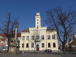
Postoloprty
Postoloprty | |
|---|---|
 Town hall | |
| Coordinates: 50°21′38″N 13°41′45″E / 50.36056°N 13.69583°E | |
| Country | |
| Region | Ústí nad Labem |
| District | Louny |
| First mentioned | 1125 |
| Government | |
| • Mayor | Zdeněk Pištora |
| Area | |
• Total | 46.49 km2 (17.95 sq mi) |
| Elevation | 193 m (633 ft) |
| Population (2024-01-01)[1] | |
• Total | 4,703 |
| • Density | 100/km2 (260/sq mi) |
| Time zone | UTC+1 (CET) |
| • Summer (DST) | UTC+2 (CEST) |
| Postal codes | 439 42, 440 01 |
| Website | www |
Postoloprty (Czech pronunciation: [ˈpostolopr̩tɪ]; German: Postelberg) is a town in Louny District in the Ústí nad Labem Region of the Czech Republic. It has about 4,700 inhabitants.
Administrative parts
[edit]The villages of Březno, Dolejší Hůrky, Hradiště, Levonice, Malnice, Mradice, Rvenice, Seletice, Seménkovice, Skupice, Strkovice and Vrbka are administrative parts of Postoloprty. Dolejší Hůrky forms an exclave of the municipal territory.
Etymology
[edit]The town's name was probably derived from the Latin name of the monastery, Porta Apostolorum. Another theory says the name was derived from Old Czech prtati postole, meaning "to repair shoes". The first written mention of Postoloprty was under the name Postolopirth.[2]
Geography
[edit]Postoloprty is located about 7 kilometres (4 mi) west of Louny and 41 km (25 mi) southwest of Ústí nad Labem. It lies mostly in the Most Basin, in an agricultural landscape. The eastern part of the municipal territory with the Březno village lies in the Lower Ohře Table. The town is situated at the confluence of the rivers Ohře and Chomutovka, on the left bank of the Ohře and on the right bank of the Chomutovka.
A distinctive geologic outcrop of the Cretaceous period is located near the village of Březno (Březenské souvrství). Today, it is protected as a nature monument.[3]
History
[edit]
The settlement was first mentioned in the Chronica Boemorum, written in 1119–1125 by Cosmas of Prague. A Benedictine monastery with the Church of the Blessed Virgin Mary was founded here probably at the end of the 11th century. It was built near the site where a former Slavic gord called Drahúš on the Ohře river had been erected at the behest of the Přemyslid dukes. The monastery's premises were devastated during the Hussite Wars in 1420 and not rebuilt.[2]
In 1454, the Bohemian King George of Poděbrady enfeoffed his sons with the Postoloprty estates. The lands were leased to the noble Veitmile (Weitmühl) family in 1480. During their rule, the settlement prospered, and in 1510, it obtained town privileges by King Vladislaus II. In 1611, the owners had a castle erected at the site of the former monastery. The lordship had passed to the noble House of Schwarzenberg in 1692, the family held the premises until 1945.[2]
Upon the 1938 Munich Agreement, the area was annexed by Nazi Germany and incorporated into the Reichsgau Sudetenland. When the region returned to the Czechoslovak Republic at the end of World War II, the remaining 'Sudeten German' population was expelled according to the Beneš decrees. Outrages culminated in a massacre on 3–7 June 1945, when about 800 German civilians, mainly men who had been deported to Postoloprty from nearby Žatec, were tortured and shot. The incidents were inquired by a committee of the Czechoslovak parliament in 1947. It is the largest known killing of ethnic Germans by Czechs after World War II.[4] 763 bodies were exhumed but other death toll estimates are higher. The Postoloprty citizens disagreed whether to build a memorial or to not acknowledge the massacre;[5] a memorial plaque was unveiled on 3 June 2010.[4]
Demographics
[edit]
|
|
| ||||||||||||||||||||||||||||||||||||||||||||||||||||||
| Source: Censuses[6][7] | ||||||||||||||||||||||||||||||||||||||||||||||||||||||||
Transport
[edit]A section of the D7 motorway passes through the town.
Postoloprty lies on the Žatec–Most railway line and is the terminus and starting point of the Česká Lípa – Postoloprty line.[8]
Sights
[edit]
The main landmark of Postoloprty is the Church of the Assumption of the Virgin Mary. This Baroque church was built in 1746–1753.[9]
The Postoloprty Castle was rebuilt in the Baroque style in 1706–1718. Its present appearance is the result of the reconstruction in 1772–1790, after it was damaged by a fire. It is surrounded by a castle garden. Today the castle is unused and fell into desrepair.[10]
Notable people
[edit]- Antonín Langweil (1791–1837), artist and model maker
- Julius Anton Glaser (1831–1885), Austrian jurist and politician
- Eduard Bacher (1846–1908), Austrian jurisconsult and journalist
- Adolf Dobrovolný (1864—1934), actor and radio announcer
- Jan Burka (1924–2009), artist
Twin towns – sister cities
[edit]Postoloprty is twinned with:[11]
 Wolkenstein, Germany
References
[edit]- ^ "Population of Municipalities – 1 January 2024". Czech Statistical Office. 2024-05-17.
- ^ a b c "Historie města" (in Czech). Město Postoloprty. Retrieved 2021-07-27.
- ^ "Březno u Postoloprt" (in Czech). Czech Geological Survey. Retrieved 2022-09-06.
- ^ a b Bártová, Eliška (2010-09-04). "Poválečný masakr Němců dostal pomník. Ale absurdní" (in Czech). Aktuálně.cz. Retrieved 2022-09-06.
- ^ Stoldt, Hans-Ulrich (2009-09-04). "Czech Town Divided over How to Commemorate 1945 Massacre". Der Spiegel. Retrieved 2022-09-06.
- ^ "Historický lexikon obcí České republiky 1869–2011" (in Czech). Czech Statistical Office. 2015-12-21.
- ^ "Population Census 2021: Population by sex". Public Database. Czech Statistical Office. 2021-03-27.
- ^ "Detail stanice Postoloprty" (in Czech). České dráhy. Retrieved 2023-06-14.
- ^ "Kostel Nanebevzetí Panny Marie" (in Czech). National Heritage Institute. Retrieved 2023-06-20.
- ^ "Zámek" (in Czech). National Heritage Institute. Retrieved 2023-06-20.
- ^ "Spolupráce" (in Czech). Město Postoloprty. Retrieved 2023-08-06.


