Portal:New Zealand/Selected picture
Selected picture 1
Portal:New Zealand/Selected picture/1

Backdropped by a colourful Earth, astronaut Robert L. Curbeam, Jr. (left) and European Space Agency (ESA) astronaut Christer Fuglesang, both STS-116 mission specialists, participate in the mission's first of three planned sessions of extravehicular activity as construction resumes on the International Space Station. The landmasses depicted are the South Island (left) and North Island (right) of New Zealand.
Selected picture 2
Portal:New Zealand/Selected picture/2

Picton (Māori: Waitohi) is a town in the Marlborough Region of New Zealand's South Island. The town is located near the head of the Queen Charlotte Sound / Tōtaranui, 25 km (16 mi) north of Blenheim and 65 km (40 mi) west of Wellington. Waikawa lies just north-east of Picton and is considered to be a contiguous part of the Picton urban area. (Full article...)
Selected picture 3
Portal:New Zealand/Selected picture/3

New Zealand Parliament Buildings (Māori: Ngā whare Paremata) house the New Zealand Parliament and are on a 45,000 square metre site at the northern end of Lambton Quay, Wellington. From north to south, they are the Parliamentary Library building (1899); the Edwardian neoclassical-style Parliament House (1922); the executive wing, called "The Beehive" (1977); and Bowen House (in use since 1991). Currently, an additional building for housing Members of Parliament is under construction, which is expected to be completed in 2026. Whilst most of the individual buildings are outstanding for different reasons, the overall setting that has been achieved "has little aesthetic or architectural coherence". (Full article...)
Selected picture 4
Portal:New Zealand/Selected picture/4

Queenstown (Māori: Tāhuna) is a resort town in Otago in the south-west of New Zealand's South Island. It is the seat and largest town in the Queenstown-Lakes District. (Full article...)
Selected picture 5
Portal:New Zealand/Selected picture/5
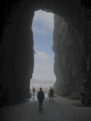
The Cathedral Caves is a large V shaped limestone sea cave located on Waipati Beach, 15 kilometres (9.3 mi) south of Papatowai, on the Catlins Coast in the southeast corner of New Zealand's South Island. The two main entrances join together within the cliff to form one big cave. One arm of the cave has a 30 metres (98 ft) high ceiling. Often blue penguins will emerge from the gloom at the far end of the cave. And occasionally a sealion might be around. (Full article...)
Selected picture 6
Portal:New Zealand/Selected picture/6

Lyttelton (Māori: Ōhinehou or Māori: Riritana) is a port town on the north shore of Lyttelton Harbour / Whakaraupō, at the northwestern end of Banks Peninsula and close to Christchurch, on the eastern coast of the South Island of New Zealand. (Full article...)
Selected picture 7
Portal:New Zealand/Selected picture/7

Muriwai, also called Muriwai Beach, is a coastal community on the west coast of the Auckland Region in the North Island of New Zealand. The black-sand surf beach and surrounding area is a popular recreational area for Aucklanders. The Muriwai Regional Park includes a nesting site for a large colony of gannets. (Full article...)
Selected picture 8
Portal:New Zealand/Selected picture/8
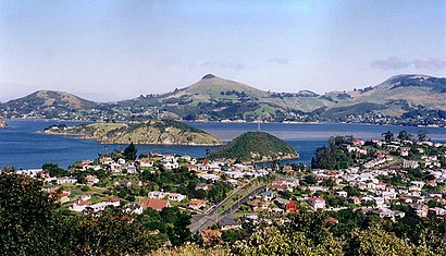
Port Chalmers (Māori: Kōpūtai) is a town serving as the main port of the city of Dunedin, New Zealand. Port Chalmers lies ten kilometres inside Otago Harbour, some 15 kilometres northeast of Dunedin's city centre. (Full article...)
Selected picture 9
Portal:New Zealand/Selected picture/9

Waiouru is a small town in the Ruapehu District, in New Zealand's Manawatū-Whanganui region. It is located on the south-eastern North Island Volcanic Plateau, 130 km (81 mi) north of Palmerston North and 25 kilometres south-east of Mount Ruapehu. The town had a population of 765 in the 2018 census. (Full article...)
Selected picture 10
Portal:New Zealand/Selected picture/10

Jane Gardner Batten CBE OSC (15 September 1909 – 22 November 1982), commonly known as Jean Batten, was a New Zealand aviator who made several record-breaking flights – including the first solo flight from England to New Zealand in 1936. (Full article...)
Selected picture 11
Portal:New Zealand/Selected picture/11

The New Zealand national rugby union team, commonly known as the All Blacks, represents New Zealand in men's international rugby union, which is considered the country's national sport. Famed for their international success, the All Blacks have often been regarded as one of the most successful sports teams in history. (Full article...)
Selected picture 12
Portal:New Zealand/Selected picture/12

Napier (/ˈneɪpiər/ NAY-pee-ər; Māori: Ahuriri) is a city on the eastern coast of the North Island of New Zealand and the seat of the Hawke's Bay region. It is a beachside city with a seaport, known for its sunny climate, esplanade lined with Norfolk pines, and extensive Art Deco architecture. For these attributes, Napier is sometimes romantically referred to as the "Nice of the Pacific". (Full article...)
Selected picture 13
Portal:New Zealand/Selected picture/13

Selected picture 14
Portal:New Zealand/Selected picture/14

Selected picture 15
Portal:New Zealand/Selected picture/15

Selected picture 16
Portal:New Zealand/Selected picture/16

The Christchurch Art Gallery Te Puna o Waiwhetū, commonly known as the Christchurch Art Gallery, is the public art gallery of the city of Christchurch, New Zealand. It has its own substantial art collection and also presents a programme of New Zealand and international exhibitions. It is funded by Christchurch City Council. The gallery opened on 10 May 2003, replacing the city's previous public art gallery, the Robert McDougall Art Gallery, which had opened in 1932. (Full article...)
Selected picture 17
Portal:New Zealand/Selected picture/17
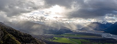
The Waimakariri River is one of the largest rivers in Canterbury, on the eastern coast of New Zealand's South Island. It flows for 151 kilometres (94 mi) in a generally southeastward direction from the Southern Alps across the Canterbury Plains to the Pacific Ocean. (Full article...)
Selected picture 18
Portal:New Zealand/Selected picture/18
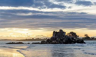
Shag Rock (also known as Rapanui) is a sea stack that marks the entrance of the Avon Heathcote Estuary near Christchurch, New Zealand. It is a prominent landmark for navigators at sea as well as travelers on the road to Sumner. The rock stands close to the southern shore just above the low tide level. In the February 2011 Christchurch earthquake it shattered and the remains, which are still easily seen from the road, have, with dark humour by some locals, been called "Shag Pile" (a pun referencing the style of carpet). (Full article...)
Selected picture 19
Portal:New Zealand/Selected picture/19

Selected picture 20
Portal:New Zealand/Selected picture/20

