Mellat Park
| Mellat Park | |
|---|---|
 | |
 | |
| Type | Urban park |
| Location | Tehran, Iran |
| Coordinates | 35°46′42″N 51°24′38″E / 35.7784°N 51.4105°E |
| Related websites | www.cinemamellat.com |
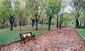
Mellat Park (Persian: پارک ملت Pārk e Mellat), literally the Nation Park, is an urban park in northern Tehran, Iran.
It is one of the city's largest green spaces,[1] situated adjacent to Valiasr Street at the foot of the Alborz mountains to the east, extending to Chamran Expressway and Seoul Street to the west.
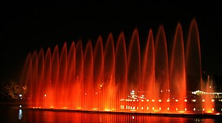
The park lies in the southern grounds of Tehran International Fair and the Enghelab Club. It is home to one of the first musical fountains in Tehran.[2]
Before the 1979 Revolution, it was known as the Imperial Park (پارک شاهنشاهی Pārk e Šāhanšāhi). It is also the location of a steam-powered locomotive used on Iran's first railway section, built between 1886 and 1888.[3] The locomotive was built by Belgian group Ateliers de Tubize, commissioned in 1887.
Mellat Gallery and Cineplex
[edit]Mellat Gallery and Cineplex is located to the southeast of the park. It was designed by architects Reza Daneshmir and Catherine Spiridonoff in an area of about 6,000 square meters,[4] and was first opened on November 9, 2008.
The complex includes four theater halls, a cinematheque, and a space for holding exhibitions and marketing cultural products.[5]
Gallery
[edit]-
Mount Tochal seen from Mellat Park.
-
A cafeteria inside Mellat Park.
-
Mellat Cineplex
-
People walking at Mellat Park.
-
Mellat Park in autumn.
-
Mellat Park in autumn.
-
Mellat Park in winter.
-
Yellow tulips at Mellat Park.
-
A vulture at the aviary of Mellat Park.
-
Fountains at Mellat Park.
References
[edit]- ^ Negar Azimi (April 28, 2017). "The Charming, Disgusting Paintings of Tala Madani". The New Yorker.
- ^ Mehdi Soltanzadeh (March 14, 2009). Musical Fountains in Mellat Park. Tehran, Iran.
- ^ Oris, Michel. Potelle, Jean-François. (1995). "Les Wallons hors de la Wallonie" (in French).
{{cite web}}: CS1 maint: multiple names: authors list (link) - ^ "Mellat Park Cineplex / Fluid Motion Architects". ArchDaily. March 3, 2011.
- ^ "Mellat Cinema Complex opens in Tehran". Tehran Times. November 11, 2008.


