Palitana State
Appearance
(Redirected from Palitana (state))
| Palitana State | |||||||
|---|---|---|---|---|---|---|---|
| Princely State of British India | |||||||
| 1194–1948 | |||||||
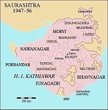
 Location of Palitana in Saurashtra | |||||||
| Area | |||||||
• 1921 | 777 km2 (300 sq mi) | ||||||
| Population | |||||||
• 1921 | 58,000 | ||||||
| History | |||||||
• Established | 1194 | ||||||
| 1948 | |||||||
| |||||||

Palitana was a princely state in British India until 1948. The capital was the city of Palitana. It ceased to exist when India became independent.[citation needed]
History
[edit]Palitana was a princely state in British India. It formed a part of the Kathiawar Agency of the Bombay Presidency.[1] Area, 289 sq. m.; pop. (1901), 52,856, showing a decrease of 15% in the decade.[1] Gross revenue, £42,000; tribute jointly to the Gaekwar of Baroda and the Nawab of Junagadh, £700. The capital of the state, Palitana, had a population of 12,800.[1] Its ruler enjoyed a 9-guns salute.[2]
See also
[edit]References
[edit]- ^ a b c Chisholm, Hugh, ed. (1911). . Encyclopædia Britannica. Vol. 20 (11th ed.). Cambridge University Press. p. 635.
- ^ Columbia-Lippincott Gazetteer p. 1417.

