Pâlis
Appearance
(Redirected from Palis)
You can help expand this article with text translated from the corresponding article in French. (December 2008) Click [show] for important translation instructions.
|
Palis | |
|---|---|
Part of Aix-Villemaur-Pâlis | |
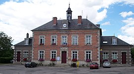
 Town hall | |
| Coordinates: 48°17′19″N 3°42′34″E / 48.2886°N 3.7094°E | |
| Country | France |
| Region | Grand Est |
| Department | Aube |
| Arrondissement | Troyes |
| Canton | Aix-Villemaur-Pâlis |
| Commune | Aix-Villemaur-Pâlis |
Area 1 | 20.89 km2 (8.07 sq mi) |
| Population (2021)[1] | 709 |
| • Density | 34/km2 (88/sq mi) |
| Time zone | UTC+01:00 (CET) |
| • Summer (DST) | UTC+02:00 (CEST) |
| Postal code | 10190 |
| Elevation | 165–269 m (541–883 ft) (avg. 166 m or 545 ft) |
| 1 French Land Register data, which excludes lakes, ponds, glaciers > 1 km2 (0.386 sq mi or 247 acres) and river estuaries. | |
Pâlis (French pronunciation: [palis][2][3]), officially Palis, is a former commune in the Aube department in north-central France. On 1 January 2016, it was merged into the new commune Aix-Villemaur-Pâlis.[4]
Population
[edit]| Year | Pop. | ±% p.a. |
|---|---|---|
| 2006 | 602 | — |
| 2011 | 629 | +0.88% |
| 2021 | 709 | +1.20% |
| Source: INSEE[5][1] | ||
See also
[edit]References
[edit]- ^ a b "Populations légales 2021" [Legal populations 2021] (PDF) (in French). INSEE. December 2023.
- ^ L'Art au service de la Ruralité (Pâlis, Aube), archived from the original on 2021-12-21, retrieved 2021-08-03
- ^ Aube reporter : Fête du vin et du terroir de Pâlis, archived from the original on 2021-12-21, retrieved 2021-08-03
- ^ Arrêté préfectoral 15 December 2015 (in French)
- ^ Populations légales 2011, INSEE
Wikimedia Commons has media related to Palis.


