Bergamasque Alps
Appearance
(Redirected from Orobic Alps)
| Bergamasque Alps | |
|---|---|
| Bergamo Alps | |
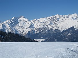
 Orobie Alps in winter | |
| Highest point | |
| Peak | Pizzo di Coca |
| Elevation | 3,050 m (10,010 ft) |
| Naming | |
| Native name | Alpi Orobie (Italian) |
| Geography | |
 | |
| Country | |
| Provinces | |
| Region | |
| Range coordinates | 46°4′7″N 10°0′42″E / 46.06861°N 10.01167°E |
| Parent range | Bergamasque Alps and Prealps |
| Borders on | |
| Geology | |
| Orogeny | Alpine orogeny |
| Rock types | |
The Bergamasque Alps or Bergamo Alps (Italian: Alpi Orobie; sometimes translated into English as Orobic Alps) are a mountain range in the Italian Alps. They are located in northern Lombardy and named after the city Bergamo, south of the mountains. Within the Eastern Alps, the Alpine Club or AVE system places them within the Western Limestone Alps, while the SOIUSA system classifies them within the Southeastern Alps.
Peaks
[edit]The main peaks of the Bergamasque Alps are:
| Peak | Elevation | |
|---|---|---|
| (m) | (ft) | |
| Pizzo di Coca | 3,050 | 10,010 |
| Pizzo di Scais | 3,040 | 9,974 |
| Pizzo Redorta | 3,037 | 9,964 |
| Pizzo Porola[1] | 2,981 | 9,780 |
| Dente di Coca | 2,924 | 9,593 |
| Pizzo del Diavolo della Malgina | 2,924 | 9,593 |
| Pizzo del Diavolo di Tenda | 2,915 | 9,564 |
| Monte Torena | 2,911 | 9,551 |
| Pizzo Recastello | 2,888 | 9,475 |
| Cime di Caronella | 2,871 | 9,419 |
| Monte Gleno | 2,883 | 9,459 |
| Pizzo Strinato | 2,836 | 9,304 |
| Pizzo di Rodes | 2,829 | 9,281 |
| Pizzo dei Tre Confini | 2,824 | 9,265 |
| Monte Grabiasca | 2,705 | 8,875 |
| Monte Masoni | 2,663 | 8,737 |
| Corno Stella | 2,620 | 8,596 |
| Monte Legnone | 2,610 | 8,563 |
| Monte Venerocolo | 2,590 | 8,500 |
| Pizzo dei Tre Signori | 2,554 | 8,380 |
| Monte Chierico | 2,535 | 8,317 |
| Pizzo del Becco | 2,507 | 8,225 |
| Pizzo Farno | 2,506 | 8,222 |
| Monte Madonnino | 2,502 | 8,209 |
| Monte Ponteranica | 2,378 | 7,802 |
| Monte Pegherolo | 2,369 | 7,772 |
| Cime di Lemma | 2,348 | 7,703 |
| Monte Cavallo | 2,323 | 7,621 |
| Monte Triomen | 2,251 | 7,385 |
| Pizzo Rotondo | 2,237 | 7,339 |
| Monte Avaro | 2,088 | 6,850 |
| Monte Cornagera | 1,312 | 4,304 |
| Corno Guazza | 1,270 | 4,170 |
| Monte Farno | 1,250 | 4,100 |
Passes
[edit]The main mountain passes of the Bergamasque Alps are:
| Pass | Location | Type | Elevation (m/ft) | |
|---|---|---|---|---|
| Passo di Val Morta or del Diavolo | Valle Seriana to Sondrio | footpath | 2,601 | 8,534 |
| Passo di Venina | Valle Brembana to Sondrio | footpath | 2,433 | 7,983 |
| Passo del Serio | Valle Seriana to Sondrio | footpath | 2,419 | 7937 |
| Passo del Venerocolo | Val di Scalve to Aprica | bridle path | 2,315 | 7,595 |
| Passo di Dordona | Valle Brembana to Sondrio | footpath | 2,080 | 6,824 |
| Passo San Marco | Bergamo to Morbegno | road | 1,985 | 6,513 |
| Passo del Vivione | Val di Scalve to Edolo | road | 1,819 | 5,968 |
| Aprica Pass | Edolo to Sondrio | road | 1,181 | 3,875 |
| Passo di Tartano | Valleve to Tartano | footpath | 2,108 | 6,425 |
Gallery
[edit]-
Barbellino Lake
-
Valbondione, in the Park of the Bergamo Orobic Alps
-
Prà de'Lac
-
Redorta
-
Recastello
-
Recastello
-
Pizzo Coca
-
View of Punta Scais peak from Gromo
-
Bergamo Alps in Mid-summer
Panorama
[edit]-
Winter panorama
Wikimedia Commons has media related to Bergamo Alps.
Maps
[edit]- Italian official cartography (Istituto Geografico Militare - IGM); on-line version: www.pcn.minambiente.it
See also
[edit]References
[edit]- ^ "Porola (Pizzo) Cresta NE - Alpinismo | Escursione in alta montagna a Valbondione, Lombardia - Gulliver Outdoor Community". gulliver.it. 27 July 2008. Retrieved 2024-01-14.


