Onanole
Appearance
(Redirected from Onanole, Manitoba)
Onanole | |
|---|---|
 | |
 | |
| Country | Canada |
| State | Manitoba |
| County | Municipality of Harrison Park |
| Time zone | UTC−6 (CDT) |
| • Summer (DST) | UTC−5 (DST) |
Onanole is a community the Municipality of Harrison Park in Manitoba, Canada, popular as a summer colony.
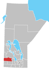
Onanole is located in southwest Manitoba, at the south entrance to Riding Mountain National Park. It sits roughly 105 km (65 mi) due north of the city of Brandon, and 135 km (84 mi) east of the Saskatchewan border.
The community was first recognized when a post office opened in 1928, with Neil W. Tracy as postmaster. The name was suggested by Tracy, after the Onanole Hotel in the Adirondack Mountains in northeastern New York, similarly situated "on a knoll".[1]
References
[edit]- ^ "Geographical Names of Manitoba" (PDF). Manitoba Geographical Names Program. Millennium Bureau of Canada: 540. Archived from the original (PDF) on November 18, 2017. Retrieved August 30, 2018.
External links
[edit]Wikimedia Commons has media related to Onanole.
50°37′21″N 99°58′05″W / 50.62250°N 99.96806°W

