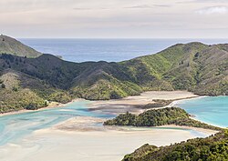
Ōkiwi Bay
Ōkiwi Bay | |
|---|---|
 Whangarae Bay | |
 | |
| Coordinates: 41°06′45″S 173°39′36″E / 41.11250°S 173.66000°E | |
| Country | New Zealand |
| Region | Marlborough |
| Ward |
|
| Electorates | |
| Government | |
| • Territorial Authority | Marlborough District Council |
| • Marlborough District Mayor | Nadine Taylor |
| • Kaikōura MP | Stuart Smith |
| • Te Tai Tonga MP | Tākuta Ferris |
| Area | |
• Total | 1.08 km2 (0.42 sq mi) |
| Population (June 2024)[2] | |
• Total | 70 |
| • Density | 65/km2 (170/sq mi) |
Ōkiwi Bay is a small town in the Marlborough Sounds, New Zealand, within Croisilles Harbour. It has about 200 houses and about 80 permanent residents.[3] The area was noted for its oysters.[4][5]
Name
[edit]Ōkiwi Bay officially had a macron added to its name on 5 November 2018 by the New Zealand Geographic Board.[6] The New Zealand Ministry for Culture and Heritage gives a translation of "place of the kiwi" for Ōkiwi.[7]
About
[edit]There were pre-European Maori settlements in this area and the Bay's name dates from those times. The primary Ngāti Koata settlement in the area was at Whangarae, adjacent to Okiwi Bay on the western side of Goat Hill.[8] In 1880 50 acres was leased by the Crown to Alabby Hobbs.[9] A saw mill was opened in the 1890s by Messrs Mace and Holland who had lease 3,200 acres of Maori land.[10][11] A track to the Rai Valley was made in 1895.[12] By 1904 Okiwi Bay had become a popular destination for holiday makers,[13]
In 1957 a unique patu was uncovered while excavating a load of single from a beach in Okiwi Bay. The patu was described as being stone and resembling a medieval mace. The style was more in line with those from the Chatham Islands, but the stone was definitely of local, Okiwi Bay, origin.[14]
It is a base for the Okiwi Bay Voluntary Rural Fire Force and St John's Ambulance. There is a holiday park and the area is predominantly a holiday resort.[3] In 2015 when a Dutch aquaculture company, Skretting, proposed setting up a fish farm in the Bay, local residents protested against it, stating that it would ruin the natural resources of the area.[15] The Environment Court granted permission for Skretting's to proceed in 2016.[16] In 2017 the settlement got mobile phone coverage.[17]
Demographics
[edit]Ōkiwi Bay is described by Statistics New Zealand as a rural settlement. It covers 1.08 km2 (0.42 sq mi)[1] and had an estimated population of 70 as of June 2024,[2] with a population density of 65 people per km2. It is part of the larger Marlborough Sounds West statistical area.[18]
| Year | Pop. | ±% p.a. |
|---|---|---|
| 2006 | 99 | — |
| 2013 | 81 | −2.83% |
| 2018 | 63 | −4.90% |
| Source: [19] | ||
Ōkiwi Bay had a population of 63 at the 2018 New Zealand census, a decrease of 18 people (−22.2%) since the 2013 census, and a decrease of 36 people (−36.4%) since the 2006 census. There were 36 households, comprising 30 males and 33 females, giving a sex ratio of 0.91 males per female. The median age was 66.0 years (compared with 37.4 years nationally), with 0 people (0.0%) aged under 15 years, 3 (4.8%) aged 15 to 29, 27 (42.9%) aged 30 to 64, and 36 (57.1%) aged 65 or older.
Ethnicities were 95.2% European/Pākehā, and 4.8% Māori.
Although some people chose not to answer the census's question about religious affiliation, 52.4% had no religion, and 33.3% were Christian.
Of those at least 15 years old, 27 (42.9%) people had no formal qualifications. The median income was $21,000, compared with $31,800 nationally. 3 people (4.8%) earned over $70,000 compared to 17.2% nationally. The employment status of those at least 15 was that 15 (23.8%) people were employed full-time, 12 (19.0%) were part-time, and 3 (4.8%) were unemployed.[19]
References
[edit]- ^ a b "ArcGIS Web Application". statsnz.maps.arcgis.com. Retrieved 20 July 2023.
- ^ a b "Aotearoa Data Explorer". Statistics New Zealand. Retrieved 26 October 2024.
- ^ a b A quaint little drinking village with a fishing problem, Stuff.co.nz, Selina Powell, published 10:14 Jun 09 2015, retrieved 26 July 2019
- ^ Nelson and Marlborough Oyster History, Ken Wright, Journal of the Nelson and Marlborough Historical Societies, Volume 2, Issue 4, 1990, Nelson Historical Society (Inc.), Nelson
- ^ Tracks, Colonist, 31 December 1900, Page 4
- ^ Okiwi Bay, National Library of New Zealand
- ^ "1000 Māori place names". New Zealand Ministry for Culture and Heritage. 6 August 2019.
- ^ The Croixelles Maori School, Nelson Evening Mail 14 November 1904 Page 2
- ^ Government Notices, Page 2 Advertisements Column 5, Colonist, VOLUME XXIII, ISSUE 2700, 6 May 1880
- ^ New mail service, The Colonist, Nelson, Thursday, January 10, 1895, page 2
- ^ Tenders, Colonist, page 2, 19 January 1898
- ^ Pelorous Guardian and Miners Advocate, 22 January 1895
- ^ The contraband of war question, Nelson Evening Mail 28 September 1904 Page 2
- ^ Journal of the Polynesian Society, Volume 68 1959, No. 2, An unrecorded type of patu from western Marlborough Sounds, G. Leslie Adkin, p 86–92
- ^ Okiwi Bay residents protest against fish farm, Newshub, 26 March 2016, Emily Cooper, retrievedc 26 July 2019
- ^ Skretting Ltd granted permission to establish a finfish research facility at Okiwi Bay in the Marlborough Sounds, Stuff.co.nz, Elena McPhee, 18:14, Jul 11 2016, retrieved 26 July 2019
- ^ retrieved 27 July 2019 Okiwi Bay gets coverage for boating season Wednesday, 1 November 2017, 1:37 pm Press Release: Spark NZ
- ^ 2018 Census place summary: Marlborough Sounds West
- ^ a b "Statistical area 1 dataset for 2018 Census". Statistics New Zealand. March 2020. 7023225.
