National Register of Historic Places listings in Gratiot County, Michigan
Appearance
(Redirected from National Register of Historic Places in Gratiot County, Michigan)

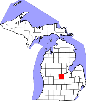
This is a list of the National Register of Historic Places listings in Gratiot County, Michigan.
This is intended to be a complete list of the properties and districts on the National Register of Historic Places in Gratiot County, Michigan, United States. Latitude and longitude coordinates are provided for many National Register properties and districts; these locations may be seen together in a map.[1]
There are 10 properties and districts listed on the National Register in the county.
This National Park Service list is complete through NPS recent listings posted November 8, 2024.[2]
Current listings
[edit]| [3] | Name on the Register[4] | Image | Date listed[5] | Location | City or town | Description |
|---|---|---|---|---|---|---|
| 1 | Alma Downtown Historic District |  |
December 11, 2013 (#13000904) |
Superior and State Streets 43°22′44″N 84°39′43″W / 43.378919°N 84.661840°W | Alma | The Alma Downtown Historic District contains 72 structures, primarily brick commercial buildings, ranging from one to three stories in height and dating from 1874 (and likely earlier) to the 1960s. |
| 2 | Brown Site (20GR21) | September 19, 1985 (#85002411) |
Pine River near Tyler Road[6] 43°20′30″N 84°42′00″W / 43.341667°N 84.7°W | Alma | The Brown Site is an archaeological site, located along the Pine River, that was the location of a late Woodland period village dating to about AD 1000. | |
| 3 | Conservation Park Site (20GR33) | September 30, 1985 (#85002695) |
Pine River Park, Alma, Michigan[7] 43°22′15″N 84°40′15″W / 43.370833°N 84.670833°W | Alma | The Conservation Park Site, also known as the Pine River Park Site, is an archaeological site located along the Pine River that was the location of an early Woodland period camp. | |
| 4 | Gratiot County Courthouse |  |
January 31, 1976 (#76002291) |
Center St. 43°17′27″N 84°36′17″W / 43.290833°N 84.604722°W | Ithaca | The Gratiot County Courthouse was constructed in 1900-02 from plans drawn by architect Claire Allen. It is a 2-1/2-story Classical Revival structure covered in beige sandstone with a distinctive multi-stage clock tower topped with a belfry. |
| 5 | Holiday Park Site (20GR91) | December 6, 1985 (#85003519) |
Holiday Park[8] 43°22′15″N 84°40′00″W / 43.370833°N 84.666667°W | Alma | The Holiday Park Site is an archaeological site that was the location of a Late Woodland period village. | |
| 6 | Ithaca Downtown Historic District |  |
December 21, 2005 (#05001510) |
100-168 and 101-161 E. Center St. 43°17′30″N 84°36′24″W / 43.291667°N 84.606667°W | Ithaca | The Ithaca Downtown Historic District encompasses 15 commercial structures, the entire 100 block of East Center Street. |
| 7 | Lincoln Road–Pine River Bridge | December 9, 1999 (#99001516) |
Lincoln Rd. over the Pine River 43°22′45″N 84°49′59″W / 43.379167°N 84.833056°W | Seville Township | This bridge is notable for being a large early example of an arched through girder bridge in Michigan, and for sitting on substantially skewed abutments. It was demolished and replaced in 2009. | |
| 8 | Dr. Charles H. MacLachlan Sanitarium and House |  |
November 22, 1982 (#82000533) |
6482 Pingree Rd. 43°23′09″N 84°44′47″W / 43.385833°N 84.746389°W | Elwell | The MacLachlan Sanitarium is a stone facility built in 1908 by Dr. Charles H. MacLachlan, a proponent of "physiological therapeutics," a treatment of chronic diseases without the use of medication. It also served as a local hospital. |
| 9 | Saint Louis Downtown Historic District |  |
December 3, 2014 (#14000976) |
N. Mill St., W. Saginaw & W. Center Aves. 43°24′35″N 84°36′32″W / 43.4097°N 84.609°W | Saint Louis | |
| 10 | Wright Opera House Block Complex |  |
June 26, 2013 (#13000443) |
101–113 E. Superior St., 408 N. State St. 43°22′45″N 84°39′41″W / 43.379176°N 84.661380°W | Alma | The Wright Opera House Block, also known as the 'Alma Opera House Block, was built in 1880 by lumberman Ammi Willard Wright. It is a large brick building houseing five commercial spaces on the first floor, and a performance space and offices on the upper floors. The 1899 Lancashire Building addition is integral to the original building. |
See also
[edit]Wikimedia Commons has media related to National Register of Historic Places in Gratiot County, Michigan.
- List of National Historic Landmarks in Michigan
- National Register of Historic Places listings in Michigan
- Listings in neighboring counties: Clinton, Ionia, Isabella, Midland, Montcalm, Saginaw, Shiawassee
References
[edit]- ^ The latitude and longitude information provided in this table was derived originally from the National Register Information System, which has been found to be fairly accurate for about 99% of listings. Some locations in this table may have been corrected to current GPS standards.
- ^ National Park Service, United States Department of the Interior, "National Register of Historic Places: Weekly List Actions", retrieved November 8, 2024.
- ^ Numbers represent an alphabetical ordering by significant words. Various colorings, defined here, differentiate National Historic Landmarks and historic districts from other NRHP buildings, structures, sites or objects.
- ^ "National Register Information System". National Register of Historic Places. National Park Service. April 24, 2008.
- ^ The eight-digit number below each date is the number assigned to each location in the National Register Information System database, which can be viewed by clicking the number.
- ^ The NRIS lists the site as "address restricted." However, references place the location along the Pine River near Tyler Road. Geo-coordinates are approximate.
- ^ The NRIS lists the site as "address restricted." However, references place the location in Pine River Park in Alma. Geo-coordinates are approximate.
- ^ The NRIS lists the site as "address restricted." However, references place the location in Holiday Park in Alma. Geo-coordinates are approximate.


