National Register of Historic Places listings in Audubon County, Iowa
Appearance
(Redirected from National Register of Historic Places in Audubon County, Iowa)

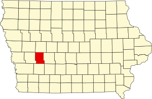
This is a list of the National Register of Historic Places listings in Audubon County, Iowa.
This is intended to be a complete list of the properties and districts on the National Register of Historic Places in Audubon County, Iowa, United States. Latitude and longitude coordinates are provided for many National Register properties and districts; these locations may be seen together in a map.[1]
There are 15 properties and districts listed on the National Register in the county.
This National Park Service list is complete through NPS recent listings posted November 8, 2024.[2]
Current listings
[edit]| [3] | Name on the Register[4] | Image | Date listed[5] | Location | City or town | Description |
|---|---|---|---|---|---|---|
| 1 | Audubon County Court House |  |
August 28, 2003 (#03000826) |
318 Leroy St. 41°43′18″N 94°55′47″W / 41.721530°N 94.929594°W | Audubon | The Audubon County Court House designed by Keffer and Jones of Des Moines in the PWA Moderne style in 1939, is significant as one of ten county courthouses built in Iowa during the New Deal Era as part of the federal Public Works Administration.[6] |
| 2 | Audubon County Courthouse |  |
July 26, 1977 (#77000493) |
Washington and Kilworth Sts. 41°35′29″N 94°52′30″W / 41.591389°N 94.875°W | Exira | Served as the Audubon County Courthouse from 1874 to 1879, and is the first building erected in the county specifically for use as a county government facility. In 1887, Knights of Pythias Lodge took over the rent, and rented the lower floor to travelling musical and theater troupes, and later to entrepreneurs who showed silent movies. Community plays and dances were also held here.[7] |
| 3 | Audubon County Home Historic District |  |
March 17, 2015 (#15000080) |
1891 215th St. 41°41′44″N 94°55′21″W / 41.695681°N 94.922570°W | Audubon | |
| 4 | Bennedsen, Boldt, and Hansen Building | October 3, 1991 (#91001460) |
Main St. 41°37′42″N 95°04′21″W / 41.628333°N 95.0725°W | Kimballton | 1913 commercial building, built by Danish immigrant settlers.[8] | |
| 5 | Bethany Danish Evangelical Lutheran Church | October 3, 1991 (#91001457) |
1.5 miles north of Iowa Highway 44 and 1 mile east of Iowa Highway 68 41°39′08″N 95°03′11″W / 41.652222°N 95.053056°W | Kimballton | 1898 church significant for its association with an important United Church congregation following the split in the Danish Lutheran Church in 1894.[9] | |
| 6 | John D. Bush House |  |
October 3, 1991 (#91001461) |
219 N. Kilworth 41°35′39″N 94°52′32″W / 41.594167°N 94.875556°W | Exira | 1873 Gabled-ell house built by Danish immigrant carpenter Jens Uriah Hansen, who was the first Dane to settle in the county.[10] |
| 7 | Andrew P. Hansen Farmstead | October 3, 1991 (#91001458) |
Between Iowa Highway 44 and County Road P58 on Little Elkhorn Creek 41°36′01″N 94°59′06″W / 41.600278°N 94.985°W | Brayton | 1894 farmstead including a hipped foursquare house built by Danish immigrants[11] | |
| 8 | Immanuel Danish Evangelical Lutheran Church |  |
October 3, 1991 (#91001462) |
Eastern side of W. 2nd St. 41°37′46″N 95°04′28″W / 41.629375°N 95.074514°W | Kimballton | Gothic and Queen Anne styled church built by Danish immigrants significant for its association with the Grundtvigian synod of the Danish Lutheran Church following the historic split within the church in 1894.[12] |
| 9 | Hans J. Jorgensen Barn |  |
October 3, 1991 (#91001452) |
Junction of Iowa Highway 44 and Main St. 41°37′55″N 95°04′25″W / 41.631944°N 95.073611°W | Kimballton | Square hipped barn with a distinctive pyramidal roofs built by Danish Immigrant settler Hans J. Jorgesen, an instrumental person in the growth of the community of Kimballton.[13] |
| 10 | Kimballton Commercial District |  |
August 18, 1995 (#95001016) |
Junction of Alfred and Main Sts. 41°37′44″N 95°04′22″W / 41.628889°N 95.072778°W | Kimballton | 1889-1940 commercial buildings, significant for their influence of the Danish immigrant and Danish American craftmanship.[14] |
| 11 | Kimballton West 2nd – West 3rd Street Residential District |  |
August 18, 1995 (#95001017) |
Roughly W. 2nd St. from Iowa Highway 44 to south of Odense St. and W. 3rd St. from Iowa Highway 44 to Esbeck St. 41°37′43″N 95°04′32″W / 41.628611°N 95.075556°W | Kimballton | Residential neighborhood with late 19th & 20th Century homes including Queen Anne, Colonial Revival, Prairie School, and Craftsman styles.[15] |
| 12 | Hans M. Koch House | October 3, 1991 (#91001453) |
Western side of Iowa Highway 173, 0.5 miles south of Kimballton 41°37′12″N 95°04′25″W / 41.62°N 95.073611°W | Kimballton | A 1908 gabled double-pile home built to serve as the manager's residence for the Crystal Springs brickworks.[16] | |
| 13 | Jens T. Larsen House | October 3, 1991 (#91001451) |
103 Main St. 41°37′37″N 95°04′23″W / 41.626944°N 95.073056°W | Kimballton | 1894 gabled ell house, a unique example of skilled Danish immigrant craftsmen, Anders and Thorvald Jensen.[17] | |
| 14 | Poplar Rural District | April 9, 1992 (#91001463) |
Roughly the area from Poplar south and west to Wolf Creek 41°40′28″N 95°06′29″W / 41.674444°N 95.108056°W | Jacksonville | Danish rural farming community of the largest rural Danish immigrant settlement in Iowa and the United States, with the district still appearing much as it did during the early 1900s.[18] | |
| 15 | Ross Grain Elevator | June 20, 2018 (#100002575) |
5940 Main St. 41°46′25″N 94°55′20″W / 41.7737°N 94.9221°W | Audubon |
See also
[edit]Wikimedia Commons has media related to National Register of Historic Places in Audubon County, Iowa.
- List of National Historic Landmarks in Iowa
- National Register of Historic Places listings in Iowa
- Listings in neighboring counties: Carroll, Cass, Guthrie, Shelby
References
[edit]- ^ The latitude and longitude information provided in this table was derived originally from the National Register Information System, which has been found to be fairly accurate for about 99% of listings. Some locations in this table may have been corrected to current GPS standards.
- ^ National Park Service, United States Department of the Interior, "National Register of Historic Places: Weekly List Actions", retrieved November 8, 2024.
- ^ Numbers represent an alphabetical ordering by significant words. Various colorings, defined here, differentiate National Historic Landmarks and historic districts from other NRHP buildings, structures, sites or objects.
- ^ "National Register Information System". National Register of Historic Places. National Park Service. April 24, 2008.
- ^ The eight-digit number below each date is the number assigned to each location in the National Register Information System database, which can be viewed by clicking the number.
- ^ "National Register of Historic Places Registration Form - Audubon County Court House". National Park Service. Retrieved 6 October 2015.
- ^ Milliman, Leon. "National Register of Historic Places Registration Form - Audubon County Courthouse (Exira)". National Park Service. Retrieved 6 October 2015.
- ^ Rogers, Leah. "National Register of Historic Places Registration Form - Bennedsen, Boldt, and Hansen Building". National Park Service. Retrieved 5 October 2015.
- ^ Rogers, Leah. "National Register of Historic Places Registration Form - Bethany Danish Evangelical Lutheran Church". National Park Service. Retrieved 5 October 2015.
- ^ Rogers, Leah. "National Register of Historic Places Registration Form - John D. Bush House". National Park Service. Retrieved 5 October 2015.
- ^ Rogers, Leah. "National Register of Historic Places Inventory – Nomination Form: Andrew P. Hansen Farmstead". National Park Service. Retrieved 5 October 2015.
- ^ Lillehoj, Jeanette. "National Register of Historic Places Inventory – Nomination Form: Immanuel Danish Evangelical Lutheran Church". National Park Service. Retrieved 5 October 2015.
- ^ Rogers, Leah. "National Register of Historic Places Registration Form - Hans J. Jorgsensen Barn". National Park Service. Retrieved 6 October 2015.
- ^ Rogers, Leah. "National Register of Historic Places Registration Form - Kimballton Commercial District". National Park Service. Retrieved 6 October 2015.
- ^ Rogers, Leah. "National Register of Historic Places Registration Form - Kimballton West 2nd--West 3rd Street Residential District". National Park Service. Retrieved 6 October 2015.
- ^ Rogers, Leah. "National Register of Historic Places Registration Form - Koch, Hans M., House". National Park Service. Retrieved 6 October 2015.
- ^ Rogers, Leah. "National Register of Historic Places Registration Form - Larsen, Jens T., House". National Park Service. Retrieved 6 October 2015.
- ^ Johnson, Roslea. "National Register of Historic Places Registration Form - Poplar Rural District". National Park Service. Retrieved 6 October 2015.


