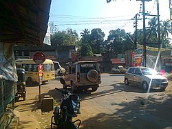
Mylakkadu
Appearance
(Redirected from Mylakkad)
This article needs additional citations for verification. (February 2023) |
Mylakkadu | |
|---|---|
Village | |
 Mylakkadu Junction | |
 | |
| Coordinates: 8°51′49″N 76°41′24″E / 8.8635°N 76.690°E | |
| Country | |
| State | Kerala |
| District | Kollam |
| Government | |
| • Body | Adichanalloor |
| Languages | |
| • Official | Malayalam, English |
| Time zone | UTC+5:30 (IST) |
| PIN | 691571 |
| Telephone code | 0474 |
| Vehicle registration | KL-2 |
| Nearest city | Kollam, Paravur, Kottiyam, Chathannoor |
| Literacy | 95% |
| Lok Sabha constituency | Kollam |
| Vidhan Sabha constituency | Chathannoor |
| Civic agency | Adichanalloor |
Mylakkadu is a small suburban village and junction in the Kollam district of the Kerala state in India.[1] It is near the town Kottiyam.

