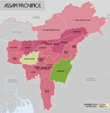
Mizo District
| Lushai Hills (1947–1954) Mizo District (1954–1972) Mizoram[1] | |||||||||
|---|---|---|---|---|---|---|---|---|---|
| Former autonomous district of Assam | |||||||||
| 1947–1972 | |||||||||
 | |||||||||
| Capital | Aizawl | ||||||||
| Population | |||||||||
• 1951 | 196,202[2] | ||||||||
• 1961 | 261,014[3] | ||||||||
• 1971 | 332,339[4] | ||||||||
| Government | |||||||||
| Deputy Commissioner | |||||||||
• 1952–1953 (first)[5] | Shri. S.N. Barkataki | ||||||||
• 1972 (last)[6] | Shri. G.C. Srivastava | ||||||||
| Historical era | Cold War | ||||||||
| 15 August 1947 | |||||||||
• Abolished chieftainship (Lushai Hills Reorganisation of Chiefs’ Rights Act, 1954)[7] | 1954 | ||||||||
• Renamed as Mizo District (The Lushai Hills District (Change of Name) Act, 1954)[8] | 1954 | ||||||||
• Mautam famine | 1959 | ||||||||
| 28 February 1966 | |||||||||
• Granted UT status | 15 August 1972 | ||||||||
| |||||||||
| Today part of | Mizoram | ||||||||
The Mizo District, formerly called Lushai Hills District, was an autonomous district of the Indian state of Assam from 1947 till 1972 until it was granted the status of a Union Territory. This region was a significant part of Mizo history as it formally abolished the Mizo chieftainship system in 1952. It also encountered the 1959 Mautam famine, which led to the Mizo National Front uprising and the subsequent 20-year insurgency.
Etymology
[edit]The original name of the district, ' Lushai Hills district, descends from a colonial misnomer. The British, upon encountering the Lusei tribes, applied the name to the Mizo people living in the region. Early administrators assumed Lushai to mean head for Lu and cut from sha or shat referring to the clan name to mean decapitation in reference to the headhunting practices of the traditional Mizo society.[9]
The Lushai Hills District (Change of Name) Act, 1954 changed the name to Mizo district.[10] Mizo connotates highlander. Mi refers to a person while zo refers to hills.[11]
History
[edit]A Lushai Hills district was formed in 1898 under British India, merging the former North Lushai Hills and South Lushai Hills regions into a single district of the Assam province. It was regarded as an Excluded Area, beyond the Inner Line, which meant that the laws and regulations of the province did not apply, and the people from the plains could not access it without a permit.
After the independence of India, the district continued to exist in the same form, with the typology changed to Scheduled Area and Inner Line in place. In addition, the district was granted an autonomous district council to formulate its own laws and regulations under the Sixth Schedule to the Constitution of India.
Prior to independence, the people of the district rallied behind a "Mizo" identity and formed a political party called Mizo Union. In 1954, the Government of India accepted their demand and changed the name of the district to Mizo District.[12]
The first Mizo chief to give up his chiefdom and chieftainship was Khawvelthanga of Maubuang (1885–1971).[13]
During the Mautam famine of the 1959, Mizo District experienced severe food shortages, and the impact on the Mizo population was profound. Over a hundred people starved to death.[14] Estimations say that around two million rats were killed and collected by the locals.

The Mizo population were extremely upset with the Assam Government as they predicted about the famine two years earlier, but no response was given. As a result, the Mizo National Famine Front was formed for the Mizo people to gain a more autonomous state.[15] In addition, in 1960, the Assam Government officialised Assamese as the official language of Assam without consideration of the Mizo language. These reasons led to the Mizo National Front uprising.
The Mizo district was superseded by the Union Territory of Mizoram with the North-Eastern Areas (Reorganisation) Act, 1971. The Mizo district consisted of two sub-divisions of Aijal and Lungleh. It was restructured with three districts subsequently.
See also
[edit]References
[edit]- ^ "Mizo Chanchin, Bu II – A History of Lushai Hills, Part II [1947]", British Library, EAP454/13/12, https://eap.bl.uk/archive-file/EAP454-13-12
- ^ "Census of India Website: Office of the Registrar General & Census Commissioner, India". www.censusindia.gov.in.
- ^ "Census of India, 1961, District Census Handbook, Lushai Hills, p172"
- ^ "Census of India Website: Office of the Registrar General & Census Commissioner, India". www.censusindia.gov.in.
- ^ "Incumbency Chart | Aizawl District, Government of Mizoram | India".
- ^ "Incumbency Chart | Aizawl District, Government of Mizoram | India".
- ^ https://academic.oup.com/book/10383/chapter-abstract/158192519?redirectedFrom=fulltext
- ^ "Section 3: Amendment of the Sixth Schedule to the Constitution | the Lushai Hills District (Change of Name) Act, 1954".
- ^ Lewin, Thomas Herbert (1874). Progressive Colloquial Exercises in the Lushai Dialect of 'Dzo' or Kuki Language: With Vocabularies and Popular Tales. Calcutta: Calcutta Central Press Company Limited.
- ^ The Lushai Hills District (Change of Name) Act, 1954 (Act). Assam legislative assembly. 1954. Retrieved 1 October 2024.
- ^ Oxford English Dictionary (March 2024). "Mizo, N. & Adj". Oxford English Dictionary. Oxford. doi:10.1093/OED/1209469017. Retrieved 1 October 2024.
- ^ Agnihotri, Constitutional Development in North-East India (1996), p. 60.
- ^ Ruata Lungchuang. Understanding "Semi - Slavery" In Mizoram And How It Was Abolished. The Mizos, https://www.themizos.com/2022/09/understanding-semi-slavery-in-mizoram.html
- ^ "Mautam phenomenon in NE States".
- ^ "Playing the Piper". 27 November 2013.
Bibliography
[edit]- Agnihotri, S. K. (1996), "Constitutional Development in North-East India since 1947", in B. Datta-Ray; S. P. Agrawal (eds.), Reorganization of North-East India Since 1947, Concept Publishing Company, pp. 57–92, ISBN 978-81-7022-577-5
