Mead Ranch, Arizona
Appearance
(Redirected from Mead Ranch)
Mead Ranch, Arizona | |
|---|---|
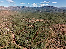
 Aerial view of Mead Ranch underneath the Mogollon Rim | |
| Coordinates: 34°20′47″N 111°8′31″W / 34.34639°N 111.14194°W | |
| Country | United States |
| State | Arizona |
| County | Gila |
| Area | |
• Total | 0.60 sq mi (1.55 km2) |
| • Land | 0.60 sq mi (1.55 km2) |
| • Water | 0.00 sq mi (0.00 km2) |
| Elevation | 6,000 ft (2,000 m) |
| Population (2020) | |
• Total | 42 |
| • Density | 70.23/sq mi (27.12/km2) |
| Time zone | UTC-7 (MST (no DST)) |
| ZIP code | 85541[2] |
| Area code | 928 |
| FIPS code | 04-45275 |
| GNIS feature ID | 40821 |
Mead Ranch is a census-designated place (CDP) in Gila County, Arizona, United States. The population was 38 at the 2010 census.[3]
Geography
[edit]The CDP is located in northern Gila County at the southern foot of the Mogollon Rim. It is 5 miles (8 km) by dirt roads north of Arizona State Route 260 at Kohls Ranch, and 21 miles (34 km) northeast of Payson. According to the United States Census Bureau, the Mead Ranch CDP has a total area of 0.60 square miles (1.55 km2), all land.[3]
Demographics
[edit]| Census | Pop. | Note | %± |
|---|---|---|---|
| 2020 | 42 | — | |
| U.S. Decennial Census[4] | |||
Education
[edit]It is in the Payson Unified School District.[5] Payson High School is the zoned comprehensive high school.
References
[edit]- ^ "2020 U.S. Gazetteer Files". United States Census Bureau. Retrieved October 29, 2021.
- ^ "Mead Ranch AZ ZIP Code". zipdatamaps.com. 2023. Retrieved May 3, 2023.
- ^ a b "Geographic Identifiers: 2010 Demographic Profile Data (G001): Mead Ranch CDP, Arizona". U.S. Census Bureau, American Factfinder. Retrieved November 1, 2016.[dead link]
- ^ "Census of Population and Housing". Census.gov. Retrieved June 4, 2016.
- ^ "2020 CENSUS - SCHOOL DISTRICT REFERENCE MAP: Gila County, AZ" (PDF). U.S. Census Bureau. Retrieved September 12, 2024. - Text list


