Mbarara–Ishaka Road
Appearance
(Redirected from Mbarara-Ishaka Road)
| Mbarara–Ishaka Road | |
|---|---|
| Route information | |
| Length | 38 mi (61 km) |
| Major junctions | |
| East end | Mbarara |
| Kabwohe Bushenyi | |
| West end | Ishaka |
| Location | |
| Country | Uganda |
| Highway system | |
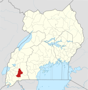
Mbarara–Ishaka Road is a road in the Western Region of Uganda, connecting the towns of Mbarara in Mbarara District with Ishaka in Bushenyi District.
Location
[edit]The road starts in Mbarara, the largest city in Western Uganda, extending westwards through Kabwohe and Bushenyi to end at Ishaka, a distance of about 61 kilometres (38 mi).[1] The coordinates of the road near Kabwohe are 0°34'46.0"S, 30°23'31.0"E (Latitude:-0.579453; Longitude:30.391942).[2]
Overview
[edit]This road is a major transport corridor in the sub-region and for traffic from the sub-region to the urban centers of Mbarara and further east, Masaka and Kampala. The road was last renovated between September 1987 and December 1994, with loans from the World Bank.[3]
See also
[edit]References
[edit]- ^ GFC (22 May 2016). "Distance between Golf Course Road, Mbarara, Western Region, Uganda and Caltex petrol station, Ntungamo-Katunguru Road, Ishaka, Western Region, Uganda". Globefeed.com (GFC). Retrieved 22 May 2016.
- ^ "Location of Mbarara–Ishaka Road" (Map). Google Maps. Retrieved 22 May 2016.
- ^ WB (1 June 1995). "Report No. 14554: Implementation Completion Report: Uganda Fourth Highway Project (CREDIT 1803-UG)". Washington, DC: World Bank (WB). Retrieved 22 May 2016.


