Maracay
This article needs additional citations for verification. (January 2008) |
Maracay | |
|---|---|
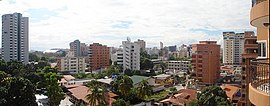
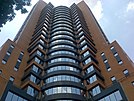
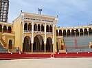
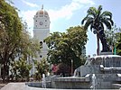
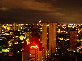
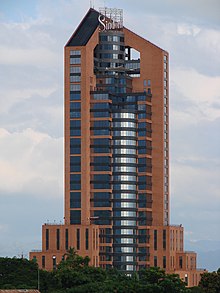
Top:Maracay Municipal Garden and Las Delicias area, Second:Sindoni Tower, Los Tamarindo residential area and overview to Maracay, Third:Maestranza Cesar Giron Bullring Stadium, Girardot Square and Maracay Assumption Cathedral, Bottom:Night view of downtown Base Aragua area (all item of left to right) | |
| Nickname(s): "Ciudad Jardín" (English: Garden City) | |
| Coordinates: 10°14′49″N 67°35′46″W / 10.24694°N 67.59611°W | |
| Country | |
| State | Aragua |
| Municipality | Girardot |
| Founded | March 5, 1701 |
| Government | |
| • Mayor | Rafael Morales[1] |
| Area | |
• Total | 911.57 km2 (351.96 sq mi) |
| Elevation | 436 m (1,430 ft) |
| Population (2020) | |
• Total | 1,302,000 |
| • Density | 1.439/km2 (3.73/sq mi) |
| • Demonym | Maracayero(a) |
| Time zone | UTC−4 (VET) |
| Postal codes | 2101, 2102, 2103, 2104 |
| Area code | 0243 |
| Climate | Aw |
| Website | Alcaldía de Maracay (in Spanish) |
| The area and population figures are for the municipality | |
Maracay (Spanish pronunciation: [maɾaˈkaj]) is a city in north-central Venezuela, near the Caribbean coast, and is the capital and most important city of the state of Aragua. Most of it falls under the jurisdiction of Girardot Municipality. The population of Maracay and its surroundings in the 2011 census was 955,362. In Venezuela, Maracay is known as "Ciudad Jardín" ("Garden City").[2]
History
[edit]


Officially established on March 5, 1701 by Bishop Diego de Baños y Sotomayor in the valleys of Tocopio and Tapatapa (what is known today as the central valley of Aragua) in northern Venezuela.
According to the most accepted explanation, it was named after a local indigenous chief, and refers to the "Maracayo" (Felis mitis), a small tiger. Alternative etymologies cite a local aromatic tree called Mara.
Maracay experienced rapid growth during Juan Vicente Gómez's dictatorship (1908–1935). Gómez saw Maracay as a suitable place to make his residence during his rule, and ordered the construction of an Arc of Triumph, a bull plaza (a near replica of the one in Seville, Spain), an Ópera house, a Zoo, and, most notably, the Hotel Jardín (Garden Hotel), a majestic, tourist attraction with very large gardens. The city is home to the Mausoleo de Gómez (Gómez's mausoleum), where the dictator is buried.
Economy and transport
[edit]One of the most important cities in Venezuela, Maracay is primarily an industrial and commercial center, the city produces paper, textiles, chemicals, tobacco, cement, cattle, processed foods, soap and perfumes.
The areas around Maracay are agricultural: sugarcane, tobacco, coffee and cocoa stand out as the main products. There are also cattle-herding and timber-cutting activities. Activity by the Venezuelan Military also adds a great deal to Maracay's economy .[citation needed].
Maracay has good transportation facilities and infrastructure [citation needed]. The city is linked to most other important localities by the Autopista Regional del Centro (Central Regional Highway). It also has good access to Venezuela's small national railway system[citation needed]. The city boasts the national hydroplane airport, located on the shore of the Lago de Valencia (Lake of Valencia). The city does not have a subway system, but one is in the planning stages.
Maracay has two airports. The Airport Mariscal Sucre (IATA MYC ICAO SVBS) and the military Air Base El Libertador (ICAO SVBL)
Climate
[edit]| Climate data for Maracay (1991–2020, extremes 1961–2020) | |||||||||||||
|---|---|---|---|---|---|---|---|---|---|---|---|---|---|
| Month | Jan | Feb | Mar | Apr | May | Jun | Jul | Aug | Sep | Oct | Nov | Dec | Year |
| Record high °C (°F) | 36.7 (98.1) |
37.5 (99.5) |
38.5 (101.3) |
37.8 (100.0) |
38.5 (101.3) |
36.1 (97.0) |
39.4 (102.9) |
35.0 (95.0) |
34.8 (94.6) |
35.4 (95.7) |
35.1 (95.2) |
35.4 (95.7) |
39.4 (102.9) |
| Mean daily maximum °C (°F) | 32.1 (89.8) |
32.8 (91.0) |
33.7 (92.7) |
33.5 (92.3) |
33.1 (91.6) |
32.1 (89.8) |
31.6 (88.9) |
31.4 (88.5) |
32.0 (89.6) |
32.2 (90.0) |
32.0 (89.6) |
32.0 (89.6) |
32.4 (90.3) |
| Daily mean °C (°F) | 24.7 (76.5) |
25.2 (77.4) |
26.3 (79.3) |
27.0 (80.6) |
27.1 (80.8) |
26.2 (79.2) |
25.6 (78.1) |
25.5 (77.9) |
26.1 (79.0) |
26.0 (78.8) |
25.7 (78.3) |
25.1 (77.2) |
25.9 (78.6) |
| Mean daily minimum °C (°F) | 18.9 (66.0) |
19.3 (66.7) |
20.5 (68.9) |
21.9 (71.4) |
22.8 (73.0) |
22.1 (71.8) |
21.5 (70.7) |
21.8 (71.2) |
22.2 (72.0) |
22.2 (72.0) |
21.6 (70.9) |
20.0 (68.0) |
21.2 (70.2) |
| Record low °C (°F) | 12.2 (54.0) |
12.0 (53.6) |
13.3 (55.9) |
13.9 (57.0) |
17.0 (62.6) |
16.6 (61.9) |
14.6 (58.3) |
15.3 (59.5) |
17.3 (63.1) |
14.5 (58.1) |
15.3 (59.5) |
8.5 (47.3) |
8.5 (47.3) |
| Average rainfall mm (inches) | 49.9 (1.96) |
28.4 (1.12) |
15.8 (0.62) |
59.6 (2.35) |
89.6 (3.53) |
124.6 (4.91) |
171.3 (6.74) |
194.0 (7.64) |
168.7 (6.64) |
181.0 (7.13) |
129.0 (5.08) |
88.1 (3.47) |
1,300 (51.18) |
| Average rainy days (≥ 1.0 mm) | 2.0 | 1.2 | 1.2 | 4.1 | 7.2 | 10.1 | 12.4 | 13.6 | 10.5 | 10.6 | 6.8 | 4.1 | 83.8 |
| Average relative humidity (%) | 71 | 68 | 66 | 68 | 74 | 78 | 80 | 81 | 80 | 80 | 78 | 74 | 75 |
| Mean monthly sunshine hours | 285.2 | 268.8 | 288.3 | 225.0 | 207.7 | 201.0 | 220.1 | 229.4 | 228.0 | 235.6 | 246.0 | 269.7 | 2,904.8 |
| Mean daily sunshine hours | 9.2 | 9.6 | 9.3 | 7.5 | 6.7 | 6.7 | 7.1 | 7.4 | 7.6 | 7.6 | 8.2 | 8.7 | 8.0 |
| Source: NOAA (sun 1961–1990)[3][4] | |||||||||||||
Military
[edit]Maracay is a city heavily influenced by the military[citation needed]. Maracay is the cradle of Venezuelan aviation, and it is home to the two largest Air Force bases in the country. The Venezuelan F-16 fighter planes are stationed here, as well as the new Sukhoi-30MKEs acquired by the Venezuelan Government.
Other military facilities include the Fourth Armored Division of the Army and the airborne training center and barracks of the 42nd Airborne Brigade.
It is also home to the government-owned ammunition and weapons factory (CAVIM) that produces the Venezuelan version of the FN FAL (Fusil Automatique Leger - Light Automatic Rifle) rifle and the AK-103s; as well as the ammunition for both models.

Natural reserves
[edit]The mountains on the north side of Maracay, that separate it from the coast, make up the Henri Pittier National Park, named after the Swiss naturalist that studied them. The park is a lush rainforest, noted for its variety of ferns[citation needed]. Two very winding roads cut through the park over the mountains to the coast. One, beginning at the North-Central part of the city known as Urbanización El Castaño, goes to the beach town of Choroní. The other, beginning at the North-Western part at the city of El Limón, goes to Ocumare de la Costa and the beaches of Cata and Cuyagua[relevant? – discuss].

Higher educational institutions and cultural venues
[edit]


Maracay houses the Faculty of Veterinarians and Agronomy of the Universidad Central de Venezuela, and an extension of the Universidad de Carabobo.
The main Campus of the UNEFA (a military university open to civilians) is located here. Career choices include electronics, aeronautical and civil engineering, and avionics[relevant? – discuss].
Museums
[edit]The main museums are:
- The Anthropological Museum.
- The Aviation Museum.
- The Museum of Modern Arts "Mario Abreu".
- The Opera House.
Religion
[edit]The Patron Saint is Saint Joseph.
The San Sebastian's Walk is a religious catholic event with ecological and sport characteristics, which takes place the 20th of January of each year in the outskirts of the city of Maracay.
Maracay has a Serbian community and Serbian Orthodox church[citation needed] [relevant?].
The city of Maracay has no synagogue. However, nine indigenous inhabitants converted to Conservative Judaism in Valencia in 2014 after a three-year study course[relevant? – discuss].[5] In 2016, they were denied the right to emigrate to Israel by the Israeli Ministry of Interior, under the assumption that they failed to "belong to a Jewish community" in Maracay.[5]
Sports
[edit]Maracay is the home of the local baseball team Tigres de Aragua.
The city's Bullfight arena is the only bullfighting school in the country. It is called "Maestranza Cesar Girón"
Gallery Images
[edit]-
Statue of a bull in Las Delicias avenue
-
Bolívar Square
-
Universidad Avenue
-
Henri Pittier National Park
-
Arnoldo Gabaldón Institute
-
Las Delicias Sports Center
Mass media
[edit]- TV Stations: TVS, TVR (Orbivisión), Color TV, TIC TV (Televisión Informativa del Centro), Novavisión TV, Aragua TV.
- Newspapers: El Aragüeño, El Periodiquito, El Siglo, El Impreso
- Maracay in the web: maracaycity.net, MaracayUp, Maracay Extrema, En Aragua, Ciudad Maracay
Notable people
[edit]- Bobby Abreu, baseball player
- Jesús Aguilar, baseball player
- Juan Arango, soccer player
- Jose Altuve, baseball player
- Elvis Andrus, baseball player
- La Divaza, YouTuber and singer
- Juan-Carlos Bianchi, tennis player
- Miguel Cabrera, baseball player
- Alberto Callaspo, baseball player
- David Concepción, baseball player
- Canserbero, rapper
- Kervin Castro, baseball player
- Yonathan Daza, baseball player
- Gaby Espino, actress, model and TV presenter
- César Girón, bullfighter
- Samin Gómez, racing driver
- Carlos Guillén, baseball player
- Gabriela Isler, Miss Universe 2013
- Luis Laguna, musician and songwriter
- Pilín León, Miss World 1981
- Alicia Machado, Miss Universe 1996
- Manuel Maldonado, racing driver
- Pastor Maldonado, Formula One driver
- Omar Narváez, baseball player
- Martín Prado, baseball player
- Sebastian Rivero, baseball player
- Maira Alexandra Rodriguez, Miss Earth Water 2014
- Aníbal Sánchez, baseball player
- Yolmer Sánchez, baseball player
- Jorge Valdivia, soccer player
References
[edit]- ^ "Divulgaciones".
- ^ "Maracay, la eterna Ciudad Jardín de Venezuela". www.el-carabobeno.com. March 5, 2018.
- ^ "Maracay Climate Normals 1991–2020". World Meteorological Organization Climatological Standard Normals (1991–2020). National Oceanic and Atmospheric Administration. Archived from the original on 18 February 2024. Retrieved 17 February 2024.
- ^ "Maracay Climate Normals 1961–1990". National Oceanic and Atmospheric Administration. Archived from the original on 18 February 2024. Retrieved 17 February 2024.
- ^ a b Maltz, Judy (January 2, 2017). "Venezuelan Jews Barred From Immigrating to Israel Because 'They Don't Belong to a Jewish Community'". Haaretz. Retrieved January 3, 2017.
External links
[edit]- Official site of the Girardot Municipality
- Map of Maracay
- Ciudad Maracay. Information about Maracay and Aragua State

