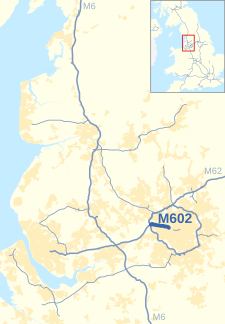
M602 motorway
| M602 | ||||
|---|---|---|---|---|
 | ||||
| Route information | ||||
| Maintained by National Highways | ||||
| Length | 4.0 mi (6.4 km) | |||
| Existed | 1971–present | |||
| History | Constructed 1971–82 | |||
| Major junctions | ||||
| West end | Eccles | |||
| ||||
| East end | Ordsall, Salford | |||
| Location | ||||
| Country | United Kingdom | |||
| Primary destinations | Salford | |||
| Road network | ||||
| ||||
The M602 motorway is a 4-mile-long (6 km) motorway, leading traffic into Salford, Greater Manchester, England, towards Manchester city centre and by-passing the town of Eccles.
History
[edit]The first section from Worsley to Eccles (now Junction 2) opened in 1971, and the second section from Eccles to Ordsall was completed in 1982.
The motorway itself was originally intended to be a part of a bigger scheme, the South Lancashire Motorway. To be designated M52, the route would have linked Liverpool and Manchester, and would have been built to provide links to the growing UK motorway network.[1]
However, at the same time, the M62 was being extended north and east of Worsley, around the north of Manchester, and on to Yorkshire, to form part of the Trans-Pennine Motorway route. This would be an upgraded version of the original plan of the East Lancashire Road, the A580, but would link onto the existing route at Worsley. It was decided that the Trans-Pennine Motorway be extended to Liverpool too, to provide a cross-country trunk route. The M62 was re-routed to run via the route of the M52 between Worsley and Liverpool. That left a short stump of the original M52 between the M62 and Ordsall, which was initially renumbered M64 and then became the M602.[citation needed] The southern end of the M62 between Worsley and Stretford became the M63 and later the M60.
The M602 was popularised in the film 28 Days Later as the location of the 42nd blockade.
List of junctions
[edit]| County | Location | mi | km | Junction | Destinations | Notes |
|---|---|---|---|---|---|---|
| Greater Manchester | Eccles | 0 | 0 | 1[coord 1] | ||
| 1.5 | 2.4 | 2[coord 2] | ||||
| Salford | 2.4 | 3.9 | 3[coord 3] | |||
| 1.000 mi = 1.609 km; 1.000 km = 0.621 mi | ||||||
- Coordinate list


