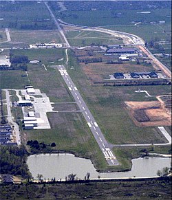
Bentonville Municipal Airport
Bentonville Municipal Airport | |||||||||||||||
|---|---|---|---|---|---|---|---|---|---|---|---|---|---|---|---|
 | |||||||||||||||
| Summary | |||||||||||||||
| Airport type | Public | ||||||||||||||
| Owner | City of Bentonville | ||||||||||||||
| Serves | Bentonville, Arkansas | ||||||||||||||
| Elevation AMSL | 1,296 ft / 395 m | ||||||||||||||
| Coordinates | 36°20′45″N 094°13′10″W / 36.34583°N 94.21944°W | ||||||||||||||
 | |||||||||||||||
| Runways | |||||||||||||||
| |||||||||||||||
| Statistics (2009) | |||||||||||||||
| |||||||||||||||
Bentonville Municipal Airport (ICAO: KVBT, FAA LID: VBT) is a city-owned, public-use airport located 2 nmi (3.7 km) south of the central business district of Bentonville, a city in Benton County, Arkansas, United States.[1] It is also known as Louise M. Thaden Field[1] or Louise Thaden Field, a name it was given in 1951 to honor Louise McPhetridge Thaden (1905–1979), an aviation pioneer from Bentonville.[2]
This airport is included in the FAA's National Plan of Integrated Airport Systems for 2009–2013, which categorizes it as a general aviation facility.[3]
Although most U.S. airports use the same three-letter location identifier for the FAA and IATA, Bentonville Municipal Airport is assigned VBT by the FAA but has no designation from the IATA.[4]
History
[edit]The airport was leased to O. W. Coda in 1956.[5]
Consideration was given to relocating Lake Bentonville to extend the runway by 1,000 ft (300 m) in 2006.[6]
The master plan for the airport was updated in 2016. Two years later, a major update of the airport was completed, including a new flight center, public meeting rooms, a museum, and a restaurant, "Louise", added to the northern border with Lake Bentonville.[7][8]
Facilities and aircraft
[edit]Bentonville Municipal Airport covers an area of 140 acres (57 ha) at an elevation of 1,296 feet (395 m) above mean sea level. It has one paved runway designated 18/36 with a surface measuring 4,426 by 65 feet (1,349 x 20 m)[1] and one turf runway measuring 2,400 by 75 feet (732 x 23 m) designated 17/35, available for use in day VFR conditions.[9]
For the 12-month period ending August 31, 2015, the airport had 32,300 aircraft operations, an average of 88 per day: 99.7% general aviation and 0.3% military. At that time there were 77 aircraft based at this airport: 87% single-engine, 7.8% multi-engine and 2.6% helicopter.[1]
See also
[edit]References
[edit]- ^ a b c d e FAA Airport Form 5010 for VBT PDF. Federal Aviation Administration. Effective 11 February 2010.
- ^ "Who Is Louise Thaden?". Summit Aviation. Archived from the original on 8 December 2008. Retrieved 4 Mar 2010.
- ^ National Plan of Integrated Airport Systems for 2009–2013: Appendix A: Part 1 (PDF, 1.33 MB) Archived August 6, 2011, at the Wayback Machine. Federal Aviation Administration. Updated 15 Oct 2008.
- ^ "Bentonville Municipal Airport (IATA: none, ICAO: KVBT, FAA: VBT)". Great Circle Mapper. Retrieved 4 Mar 2010.
- ^ "Bentonville to Lease Its Municipal Airport". Tulsa World. 30 September 1956. p. 14. Retrieved 18 October 2024.
- ^ "City Considers Relocating Lake for Runway". Jonesboro Sun. 22 November 2006. p. B3. Retrieved 18 October 2024.
- ^ "Bentonville flight center to include restaurant, exhibit space". Arkansas Online. 2017-03-21. Retrieved 2018-05-20.
- ^ Peevy, Nancy (14 August 2018). "Bentonville's Thaden Field to Become 'Destination Airport'". Talk Business & Politics. Retrieved 18 October 2024.
- ^ "Info for Pilots, Turf Runway Operations -- Summit Aviation". Summit Aviation. Retrieved 9 March 2020.
External links
[edit]- Summit Aviation, the fixed-base operator (FBO)
- Aerial image as of 28 February 2001 from USGS The National Map
- FAA Terminal Procedures for VBT, effective October 31, 2024
- Resources for this airport:
- FAA airport information for VBT
- AirNav airport information for KVBT
- FlightAware airport information and live flight tracker
- NOAA/NWS weather observations: current, past three days
- SkyVector aeronautical chart, Terminal Procedures
