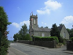
Loughgall
This article needs additional citations for verification. (May 2020) |
Loughgall
| |
|---|---|
 St Luke's Church of Ireland | |
Location within Northern Ireland | |
| Population | 282 (2011 Census) |
| Irish grid reference | H908522 |
| District | |
| County | |
| Country | Northern Ireland |
| Sovereign state | United Kingdom |
| Post town | ARMAGH |
| Postcode district | BT61 |
| Dialling code | 028 |
| UK Parliament | |
| NI Assembly | |
Loughgall (/lɒxˈɡɔːl/ lokh-GAWL; from Irish Loch gCál)[1][2] is a small village, townland (of 131 acres) and civil parish in County Armagh, Northern Ireland. It is in the historic baronies of Armagh and Oneilland West.[3] It had a population of 282 people (116 households) in the 2011 Census.[4] Loughgall was named after a small nearby loch. The village is surrounded by orchards.
History
[edit]In the Middle Ages the chiefs of the Uí Nialláin, a Gaelic clan, resided at Loughgall crannog, a fortified lake dwelling.[5] By the 16th century the O'Neills of Tír Eoghain had taken over the area, and the crannog became the residence of the O'Neill chief's brother or eldest son.[6]
In the early 1600s, the area was settled by English and Scottish Protestants as part of the Ulster Plantation. During the 1641 Irish Rebellion, settlers were held at a prison camp at Loughgall by Catholic rebels led by Manus O'Cane.[7]
In 1795, rival sectarian gangs, the Catholic Defenders and Protestant Peep-o'-Day Boys fought a bloody skirmish near the village, called the Battle of the Diamond, that left around 30 people dead. Following this, the Protestant Orange Order was founded in Dan Winter's House nearby.
The Troubles
[edit]The Loughgall area experienced a number of fatal incidents during The Troubles, the best known of which is arguably the 1987 Loughgall ambush.[8]
Sport
[edit]It is home to Loughgall Football Club, which plays in the NIFL Premiership, the top tier of football in Northern Ireland.
Education
[edit]- The Cope Primary School
- There was also a Roman Catholic primary school located on the Eagralougher Road, just outside Loughgall, but due to lack of funding and low enrolment figures the school closed in June 1996.
People
[edit]- Poet W. R. Rodgers (1909 – 1969). He later gave up the ministry and became a BBC radio producer and scriptwriter. He died in California in 1969 and was buried in Loughgall.[9]
- Cope family; MPs Robert Cope and Robert Camden Cope; and Anthony Cope (Dean of Armagh)
Civil parish of Loughgall
[edit]The civil parish contains the villages of Annaghmore, Charlemont and Loughgall.[3]
The civil parish contains the following townlands:[3]
- Aghinlig
- Altaturk
- Annaghmacmanus
- Annaghmore
- Annasamry
- Ardress East, Ardress West
- Ballygasey
- Ballymagerny
- Ballytyrone
- Borough of Charlemont
- Causanagh
- Clonmain
- Cloven Eden
- Coragh
- Corr and Dunavally
- Derrycoose
- Derrycrew
- Drumart
- Drumharriff
- Drumilly
- Drumnasoo
- Dunavally and Corr
- Eagralougher
- Fernagreevagh
- Keenaghan
- Kinnegoe
- Kishaboy
- Legavilly
- Levalleglish
- Lislasly
- Lisneany
- Lissheffield
- Loughgall
- Mullaghbane
- Mullaghmore
- Mullanasilla
- Rathdrumgran
- Tirmacrannon
- Turcarra
See also
[edit]- Market houses in Northern Ireland
- List of civil parishes of County Armagh
- List of townlands in County Armagh
References
[edit]- ^ Placenames NI Archived 2012-06-13 at the Wayback Machine
- ^ Placenames Database of Ireland
- ^ a b c "Loughgall". IreAtlas Townlands Database. Retrieved 13 May 2015.
- ^ "Loughgall". Census 2011 Results. NI Statistics and Research Agency. Archived from the original on 22 April 2015. Retrieved 22 April 2015.
- ^ Ireland's History in Maps - Uí Nialláin
- ^ "Plantation papers: containing a summary sketch of the great Ulster plantation in the year 1610". Belfast. 23 March 1889. Retrieved 1 December 2013.
- ^ Mac Cuarta, Brian. Ulster 1641: Aspects of the Rising. Institute of Irish Studies, Queen's University of Belfast, 1993. p.126
- ^ McDonald, Henry (29 September 2002). "True tale of IRA 'martyrs' revealed". The Observer. Retrieved 2 December 2024.
- ^ "Introduction - WR Rodgers Papers" (PDF). Public Record Office of Northern Ireland. Retrieved 4 March 2009.
External links
[edit]- Discover Northern Ireland
- NI Horticulture & Plant Breeding Station
- NI Conflict Archive on the Internet
- Culture Northern Ireland
- Loughgall Market House
- Loughgall Presbyterian Church


