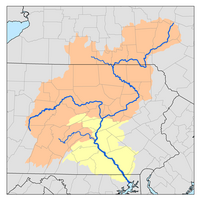
List of counties in the Susquehanna River watershed
Appearance

The Susquehanna River is in the U.S. States of Maryland, Pennsylvania and New York. As of 2000, the Susquehanna drainage basin population was 3,968,635. Its total area is 27,486 square miles (71,188 km2), and in 2000 612 square miles (1,585 km2) were developed, 8,041 square miles (20,826 km2) were used for agriculture, 18,181 square miles (47,089 km2) were forested, 27,486 square miles (71,188 km2) were open water, 127 square miles (329 km2) were wetland, and 201 square miles (521 km2) were barren. By area, the Susquehanna basin accounts for 45% of Pennsylvania, 11% of New York, and 3% of Maryland . The drainage basin is divided into six subbasins by the Susquehanna River Basin Commission. These are:
- Lower Susquehanna (green on the map at right)
- Juniata River (pink)
- West Branch Susquehanna River (orange)
- Middle Susquehanna (purple)
- Chemung River (Yellow)
- Upper Susqehanna River (brown)
Lower Susquehanna River
[edit]
- Adams County
- Berks County
- Centre County
- Chester County
- Columbia County
- Cumberland County
- Dauphin County
- Franklin County
- Juniata County
- Lancaster County
- Lebanon County
- Mifflin County
- Northumberland County
- Perry County
- Schuylkill County
- Snyder County
- Union County
- York County
Juniata River
[edit]
- Bedford County
- Blair County
- Cambria County
- Centre County
- Dauphin County
- Franklin County
- Fulton County
- Huntingdon County
- Franklin County
- Fulton County
- Juniata County
- Mifflin County
- Perry County
- Somerset County
- Snyder County
West Branch Susquehanna River
[edit]
- Blair County
- Bradford County
- Cambria County
- Cameron County
- Centre County
- Clearfield County
- Clinton County
- Columbia County
- Elk County
- Indiana County
- Jefferson County
- Lycoming County
- McKean County
- Montour County
- Northumberland County
- Potter County
- Sullivan County
- Tioga County
- Union County
- Wyoming County
Middle Susquehanna River
[edit]
- Bradford County
- Carbon County
- Columbia County
- Lackawanna County
- Luzerne County
- Lycoming County
- Montour County
- Northumberland County
- Schuylkill County
- Sullivan County
- Susquehanna County
- Tioga County
- Wayne County
- Wyoming County
Chemung River
[edit]
- Allegany County
- Chemung County
- Livingston County
- Ontario County
- Schuyler County
- Stueben County
- Tioga County
- Yates County
Upper Susquehanna River
[edit]
- Broome County
- Chemung County
- Chenango County
- Cortland County
- Delaware County
- Herkimer County
- Madison County
- Oneida County
- Onondaga County
- Otsego County
- Schoharie County
- Schuyler County
- Tioga County
- Tompkins County
References
[edit]- "Chesapeake Bay Program: Watershed Profiles: The Susquehanna Watershed". Chesapeake Bay Program Office, 10 Severn Avenue, Suite 109, Annapolis, MD 21403. Retrieved 2007-05-29.
- "Susquehanna River Basin Counties" (PDF). Map. Susquehanna River Basin Commission. Archived from the original (PDF) on 2007-09-28. Retrieved 2007-05-29.


