Lick Run (Peters Creek tributary)
Appearance
(Redirected from Lick Run (Peters Creek))
| Lick Run | |
|---|---|
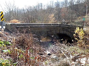
 A stone arch bridge over Lick Run. | |
 | |
| Location | |
| Country | U.S.A. (Allegheny County, Pennsylvania) |
| Physical characteristics | |
| Source | |
| • location | South Park Township, Allegheny County, Pennsylvania |
| Mouth | |
• location | Peters Creek |
• elevation | 797 ft (243 m) |
Lick Run is a 6.7-mile-long (10.8 km)[1] urban stream in southern Allegheny County, Pennsylvania, a tributary of Peters Creek.[2] The former Lick Run coal mine of the Pittsburgh Coal Company had its mouth near the stream, along the B&O Railroad line.[3]
Several stone arch bridges cross the stream. One carries Brownsville Road over the stream near Broughton. A National Landmark stone arch bridge carries Cochran Mill Road over the stream further downstream.
See also
[edit]References
[edit]- ^ U.S. Geological Survey. National Hydrography Dataset high-resolution flowline data. The National Map Archived 2012-03-29 at the Wayback Machine, accessed August 15, 2011
- ^ "Peters Creek Watershed Association".
- ^ "Baltimore and Ohio's Cutt Off" (PDF). New York Times. 3 July 1883. Retrieved 19 December 2010. https://timesmachine.nytimes.com/timesmachine/1883/07/03/103438623.pdf
40°16′40″N 79°57′22″W / 40.27778°N 79.95611°W
