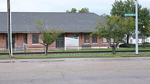
Laurel station (Mississippi)
Appearance
(Redirected from Laurel (Amtrak station))
This article lacks inline citations besides NRIS, a database which provides minimal and sometimes ambiguous information. (April 2022) |
Laurel, MS | |||||||||||||
|---|---|---|---|---|---|---|---|---|---|---|---|---|---|
 | |||||||||||||
| General information | |||||||||||||
| Location | 230 North Maple Street Laurel, Mississippi United States | ||||||||||||
| Coordinates | 31°41′32″N 89°07′41″W / 31.6922°N 89.1280°W | ||||||||||||
| Line(s) | Norfolk Southern Railway | ||||||||||||
| Platforms | 1 side platform | ||||||||||||
| Tracks | 1 | ||||||||||||
| Other information | |||||||||||||
| Status | Flag stop; unstaffed | ||||||||||||
| Station code | Amtrak: LAU | ||||||||||||
| History | |||||||||||||
| Opened | 1913 | ||||||||||||
| Passengers | |||||||||||||
| FY 2023 | 4,187[1] (Amtrak) | ||||||||||||
| Services | |||||||||||||
| |||||||||||||
| |||||||||||||
New Orleans and Northeastern Railroad Depot | |||||||||||||
| Location | Maple St., Laurel, Mississippi | ||||||||||||
| Coordinates | 31°41′32″N 89°7′39″W / 31.69222°N 89.12750°W | ||||||||||||
| Area | 2.3 acres (0.9 ha) | ||||||||||||
| Built | 1913 | ||||||||||||
| Architectural style | Bungalow/craftsman | ||||||||||||
| NRHP reference No. | 95001192[2] | ||||||||||||
| Added to NRHP | October 31, 1995 | ||||||||||||
| |||||||||||||
Laurel station is an Amtrak station at 230 North Maple Street in the heart of downtown Laurel, Mississippi. Currently served by Amtrak's Crescent passenger train, the station was originally built in 1913 by the New Orleans and Northeastern Railroad, which was acquired in 1916 by the Southern Railway.
The station is a Mississippi Landmark and has been listed on the National Register of Historic Places since October 31, 1995.

References
[edit]- ^ "Amtrak Fact Sheet, Fiscal Year 2023: State of Mississippi" (PDF). Amtrak. March 2024. Retrieved June 29, 2024.
- ^ "National Register Information System". National Register of Historic Places. National Park Service. July 9, 2010.
External links
[edit]![]() Media related to Laurel (Amtrak station) at Wikimedia Commons
Media related to Laurel (Amtrak station) at Wikimedia Commons
Categories:
- Amtrak stations in Mississippi
- Railway stations in the United States opened in 1913
- Former Southern Railway (U.S.) stations
- Railway stations on the National Register of Historic Places in Mississippi
- 1913 establishments in Mississippi
- National Register of Historic Places in Jones County, Mississippi
- Transportation in Jones County, Mississippi
- New Orleans and Northeastern Railroad

