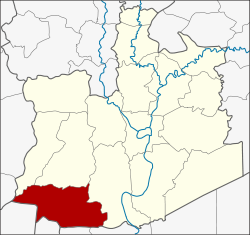
Lat Bua Luang district
Appearance
(Redirected from Lat Bua Luang District)
Lat Bua Luang
ลาดบัวหลวง | |
|---|---|
 Khlong Phraya Banlue | |
 District location in Ayutthaya province | |
| Coordinates: 14°9′57″N 100°18′27″E / 14.16583°N 100.30750°E | |
| Country | Thailand |
| Province | Ayutthaya |
| Seat | Lat Bua Luang |
| Tambon | 7 |
| Area | |
• Total | 199.9 km2 (77.2 sq mi) |
| Population (2000) | |
• Total | 36,186 |
| • Density | 181.0/km2 (469/sq mi) |
| Time zone | UTC+7 (ICT) |
| Postal code | 13230 |
| Geocode | 1410 |
Lat Bua Luang (Thai: ลาดบัวหลวง, pronounced [lâːt būa̯ lǔa̯ŋ]) is a district (amphoe) in the southern part of Ayutthaya province, central Thailand.
History
[edit]Tambon Lat Bua Luang was separated from Amphoe Bang Sai and officially upgraded to a district in 1947.
Geography
[edit]Neighbouring districts are (from the north clockwise) Bang Sai (บางซ้าย), Sena, and Bang Sai (บางไทร) of Ayutthaya Province, Sam Khok and Lat Lum Kaeo of Pathum Thani province, Sai Noi of Nonthaburi province, Bang Len of Nakhon Pathom province, and Song Phi Nong of Suphanburi province.
Administration
[edit]The district is divided into seven sub-districts (tambon). Lat Bua Luang is a township (thesaban tambon) covering parts of the tambon Lat Bua Luang.
| 1. | Lat Bua Luang | ลาดบัวหลวง | |
| 2. | Lakchai | หลักชัย | |
| 3. | Sam Mueang | สามเมือง | |
| 4. | Phraya Banlue | พระยาบันลือ | |
| 5. | Singhanat | สิงหนาท | |
| 6. | Khu Salot | คู้สลอด | |
| 7. | Khlong Phraya Banlue | คลองพระยาบันลือ |
