Kyzylorda
Kyzylorda
Қызылорда / Qyzylorda (Kazakh) | |
|---|---|
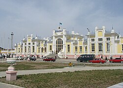
 A train station | |
| Coordinates: 44°51′0″N 65°31′0″E / 44.85000°N 65.51667°E | |
| Country | |
| Region | Kyzylorda Region |
| Founded | 1820 |
| City status | 1867 |
| Government | |
| • Akim (mayor) | Nurzhan Akhatov[1] |
| Area | |
• Total | 2,400 km2 (900 sq mi) |
| Elevation | 128 m (420 ft) |
| Population (2019) | |
• Total | 354,800 |
| • Density | 150/km2 (380/sq mi) |
| Time zone | UTC+5 |
| Postal code | 120001 - 120018 |
| Area code | +7 7242 |
| Vehicle registration | N or 11 |
| Website | www |
Kyzylorda (Kazakh: Қызылорда / Qyzylorda [qəˌzəɫorˈdɑ] ()), formerly known as Kzyl-Orda (Russian: Кзыл-Орда), Ak-Mechet (Ак-Мечеть), Perovsk (Перовск), Leninsk (Ленинск), and Fort-Perovsky (Форт-Перовский), is a city in south-central Kazakhstan, capital of Kyzylorda Region and former capital of the Kazakh ASSR from 1925 to 1927.
The city has a population of 242,462 (2020 Census). It historically developed around the Syr Darya river and was the site of a Kokand fortress. The population of the city with nearby villages is 312,861 (2020 Census).[2]
History
[edit]A settlement existed under Seljuk, the founder of the Seljuk dynasty. The modern city began in 1817[3] as the site of a Kokand fortress known as Ak-Mechet, or white mosque.[4] The later-famous Yaqub Beg was once the fort's commander, but he was not in command during the final battle. In 1853, during the Russian conquest of Turkestan, the fort was taken by Russian troops under General Vasily Perovsky.[4] The Russians established a new fort and called it Fort-Perovsky (Форт-Перо́вский), after the general.
The town of Perovsk (Перо́вск) in Russian Turkestan later developed around the fort.[4] In 1925, the city was renamed Kzyl-Orda (Кзыл-Орда)[4] and was designated as the capital of the Kazak ASSR. The name means a red city, from the Turkic "кзыл" (red; used here in the common Soviet ideological connotation) and the Turkic Mongolian "орда" (city).[4] In 1927 the capital was relocated to the southeastern region and Alma-Ata.
"Kyzylorda", the Kazakh-based Romanized spelling, has been used since the late 20th century after the dissolution of the Soviet Union and Kazakhstan's independence in 1991.[citation needed]
Since independence, many of the outhouses were erected in several apartment buildings used as dormitories during Soviet rule due to a lack of sewage systems for indoor plumbing. A RFE/RL report in April 2018 stated that the Kazakh Republic government was planning to modernize Soviet-era buildings.[5]
Climate
[edit]Kyzylorda has a cold desert climate (Köppen climate classification BWk) with hot summers and cold winters. Precipitation is low throughout the year, particularly in the summer months. Snow is common, though light, in winter. The lowest temperature on record is −36.1 °C (−33.0 °F), recorded in February 1969, and the former highest temperature was 46.0 °C (114.8 °F), recorded on July 7, 1975,[6] with the current record high temperature of 46.5 °C (115.7 °F) being recorded on July 7, 2021.[7]
| Climate data for Kyzylorda (1991–2020, extremes 1856–present) | |||||||||||||
|---|---|---|---|---|---|---|---|---|---|---|---|---|---|
| Month | Jan | Feb | Mar | Apr | May | Jun | Jul | Aug | Sep | Oct | Nov | Dec | Year |
| Record high °C (°F) | 16.8 (62.2) |
23.9 (75.0) |
31.7 (89.1) |
39.3 (102.7) |
43.3 (109.9) |
44.6 (112.3) |
46.5 (115.7) |
44.7 (112.5) |
42.0 (107.6) |
35.7 (96.3) |
26.0 (78.8) |
18.2 (64.8) |
46.5 (115.7) |
| Mean daily maximum °C (°F) | −2.5 (27.5) |
0.8 (33.4) |
10.4 (50.7) |
20.9 (69.6) |
28.2 (82.8) |
33.6 (92.5) |
35.1 (95.2) |
33.4 (92.1) |
26.6 (79.9) |
18.1 (64.6) |
7.1 (44.8) |
−0.5 (31.1) |
17.6 (63.7) |
| Daily mean °C (°F) | −6.8 (19.8) |
−4.5 (23.9) |
4.0 (39.2) |
14.0 (57.2) |
21.1 (70.0) |
26.7 (80.1) |
28.3 (82.9) |
26.2 (79.2) |
19.0 (66.2) |
10.6 (51.1) |
1.7 (35.1) |
−4.9 (23.2) |
11.3 (52.3) |
| Mean daily minimum °C (°F) | −10.6 (12.9) |
−9.1 (15.6) |
−1.4 (29.5) |
7.3 (45.1) |
13.8 (56.8) |
19.2 (66.6) |
21.0 (69.8) |
18.9 (66.0) |
11.7 (53.1) |
4.2 (39.6) |
−2.8 (27.0) |
−8.5 (16.7) |
5.3 (41.5) |
| Record low °C (°F) | −33.0 (−27.4) |
−36.1 (−33.0) |
−26.0 (−14.8) |
−12.2 (10.0) |
−0.8 (30.6) |
7.2 (45.0) |
7.8 (46.0) |
6.0 (42.8) |
−1.0 (30.2) |
−12.6 (9.3) |
−25.1 (−13.2) |
−31.0 (−23.8) |
−36.1 (−33.0) |
| Average precipitation mm (inches) | 18 (0.7) |
14 (0.6) |
15 (0.6) |
20 (0.8) |
19 (0.7) |
8 (0.3) |
5 (0.2) |
3 (0.1) |
3 (0.1) |
9 (0.4) |
16 (0.6) |
16 (0.6) |
146 (5.7) |
| Average rainy days | 4 | 4 | 6 | 6 | 6 | 4 | 3 | 2 | 2 | 5 | 6 | 5 | 53 |
| Average snowy days | 12 | 9 | 4 | 0.2 | 0.03 | 0 | 0 | 0 | 0 | 0.4 | 3 | 9 | 38 |
| Average relative humidity (%) | 78 | 74 | 65 | 49 | 41 | 35 | 34 | 34 | 40 | 52 | 70 | 77 | 54 |
| Mean monthly sunshine hours | 112 | 144 | 205 | 252 | 347 | 375 | 425 | 375 | 327 | 239 | 150 | 112 | 3,063 |
| Mean daily sunshine hours | 3.6 | 5.1 | 6.6 | 8.4 | 11.2 | 12.5 | 13.7 | 12.1 | 10.9 | 7.7 | 5.0 | 3.6 | 8.4 |
| Source 1: Pogoda.ru.net[6] | |||||||||||||
| Source 2: Deutscher Wetterdienst (sun)[8] | |||||||||||||
Agriculture
[edit]Kyzylorda is known for its rice production. Many hundreds of hectares are devoted to rice production. Two rice mills operate in the city.[9]
Education
[edit]Kyzylorda State University (KSU) after Korkyt ata[10] is the leading center of education, a science and culture center in the Aral region of the Republic Kazakhstan. Established in 1950, the university trains highly skilled specialists in 54 specialties at 11 faculties.
Transportation
[edit]
Kyzylorda has one airport. It has developed as the supply center of the important oilfields in the nearby Turgay Basin.
Tourism
[edit]Points of interest for tourists in the Kyzylorda region include the vanished Aral Sea and the Baikonur cosmodrome, archaeological excavations in Sauran and Shyganak, the memorial complex of Korkyt Ata, and several ancient mausoleums.[11]
Notable people
[edit]- Asim Thahit Abdullah Al Khalaqi (1968–2015), Yemeni formerly held in Guantanamo, given asylum by Kazakhstan in 2015
- Vladimir Hotineanu (1950–2019), former Health Minister of Moldova
- Eliezer Kulas (born 1944), Israeli politician
- Oleg Tozoni (1927–2012), engineer and inventor
- Marina Volnova (born 1989), Olympic boxer
- Ilya Ilyin (born 1988), Olympic weightlifter
- Batyrkhan Shukenov (1962–2015), Soviet, Kazakh-Russian singer
- Mihhail Kõlvart (born 1977), mayor of Tallinn
Twin towns – sister cities
[edit]Kyzylorda is twinned with:[12][13]
References
[edit]Notes
[edit]- ^ "Нового акима назначили в Кызылорде" (in Russian). inform.kz. August 28, 2024.
- ^ "Демографиялық статистика" (in Kazakh). Archived from the original on May 27, 2020. Retrieved October 26, 2020.
- ^ Valikhanof et al, The Russians in Central Asia, 1865, page 315, says " according to Kirgiz accounts, about the year 1817." Kirgiz meant Kazakh at that time.
- ^ a b c d e Pospelov, p. 24
- ^ "Toilet Trouble in Kazakhstan". April 6, 2018.
- ^ a b "Weather and Climate - Kyzylorda" (in Russian). Weather and Climate (Погода и климат). Archived from the original on November 25, 2016. Retrieved January 5, 2022.
- ^ "38062: Kzyl-Orda (Kazakhstan)". ogimet.com. OGIMET. July 7, 2021. Retrieved July 9, 2021.
- ^ "Klimatafel von Ksyl-Orda (Perowsk) / Kasachstan" (PDF). Federal Ministry of Transport and Digital Infrastructure. Retrieved September 17, 2016.
- ^ Staff US Rice Producers Association
- ^ korkyt.kz
- ^ "Kyzylorda travel guide | Caravanistan". Caravanistan. Retrieved June 22, 2018.
- ^ "Есть ли побратимы у Актау и других городов Казахстана". tumba.kz (in Russian). Tumba. May 4, 2019. Retrieved November 30, 2020.
- ^ "Kardeş Şehirler". bolu.bel.tr (in Turkish). Bolu. Retrieved November 30, 2020.
Sources
[edit]- Е. М. Поспелов (Ye. M. Pospelov). "Имена городов: вчера и сегодня (1917–1992). Топонимический словарь." (City Names: Yesterday and Today (1917–1992). Toponymic Dictionary." Москва, "Русские словари", 1993.
External links
[edit]


