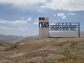
Kyzylart Pass
Appearance
(Redirected from Kyzyl-Art Pass)
| Kyzylart Pass | |
|---|---|
| Kyrgyz: Кызыл-Арт ашуусу | |
 | |
| Elevation | 4,280 m (14,042 ft) |
| Location | Kyrgyzstan–Tajikistan border |
| Range | Trans-Alay Range |
| Coordinates | 39°23′03.60″N 73°19′21″E / 39.3843333°N 73.32250°E |
Kyzylart Pass (Russian: Кызыл-Арт; Kyrgyz: Кызыл-Арт ашуусу) is a mountain pass and border crossing in the Trans-Alay Range on the border of Tajikistan and Kyrgyzstan. The highest point is 4,280 m (14,042 ft).[1] The border checkpoint on the Kyrgyz side is Bor-Döbö.[2] The area is typically rugged and dry. It is crossed by the Pamir Highway which leads south from Sary-Tash in the Alay Valley up onto the Pamir plateau toward Karakol Lake and Murghab, Tajikistan. In the late nineteenth century the Russians explored and eventually occupied the Pamir plateau.
Gallery
[edit]-
Ascent to the pass
-
Yaki on the pass
-
Kilometers on the pass
-
Pamir Highway near the Kyzyl Art Pass
References
[edit]- ^ "Кызыларт ашуусу" [Kyzylart Pass] (PDF). Кыргызстандын Географиясы [Geography of Kyrgyzstan] (in Kyrgyz). Bishkek. 2004. p. 87.
{{cite encyclopedia}}: CS1 maint: location missing publisher (link) - ^ Electronic visa information, accessed 31 January 2022.
- Laurence Mitchell, Kyrgyzstan, Bradt travel guides, 2008
- Robert Middleton and Huw Thomas, Tajikistan and the High Pamirs, Odyssey Books, 2008


