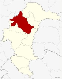
Kut Chum district
Kut Chum
กุดชุม | |
|---|---|
 District location in Yasothon province | |
| Coordinates: 16°2′0″N 104°20′17″E / 16.03333°N 104.33806°E | |
| Country | Thailand |
| Province | Yasothon |
| Seat | Kut Chum |
| Area | |
| • Total | 544.0 km2 (210.0 sq mi) |
| Population (2005) | |
| • Total | 65,959 |
| • Density | 121.25/km2 (314.0/sq mi) |
| Time zone | UTC+7 (ICT) |
| Postal code | 35140 |
| Geocode | 3503 |
Kut Chum (Thai: กุดชุม, pronounced [kùt tɕʰūm]; Northeastern Thai: กุดซุม, pronounced [kǔt su᷇m]) is a district (amphoe) of Yasothon province in northeastern Thailand.
History
[edit]The village of Kut Chum was established in 1912. A minor district (king amphoe), Kut Chum was established on 1 August 1961. It was composed of the four sub-districts: Non Pueai, Phai (in 1978 reassigned to Sai Mun District), Phon Ngan, and Kammaet, all split off from Mueang Yasothon district.[1]
On 17 July 1963, it was elevated to the level of district (amphoe), then of Ubon Ratchathani province.[2] When Yasothon was separated from Ubon, Kut Chum was one of the districts assigned to the new province.
Geography
[edit]Neighboring districts are (from the northeast clockwise): Loeng Nok Tha, Thai Charoen, Pa Tio, Mueang Yasothon, and Sai Mun of Yasothon Province, and Selaphum and Nong Phok of Roi Et province.
Economy
[edit]
Kut Chum is known for its organic movement and organic foods, chiefly the organic farming of rice.[3] Kut Chum also achieved fame for issuing its own local scrip called Bia Kut Chum. Bia, Thai for 'cowry shell', was once a unit of currency equal to 1⁄6400 of a Thai baht, and bia is still current in metaphorical expressions, so the usage ran afoul of currency laws. To side-step implications that they intended a substitute local currency, they changed to Boon Kut Chum, which are barter coupons with a fixed value in baht, that may be exchanged for goods and services in the community.[4]
Administration
[edit]The district is divided into nine sub-districts (tambons) and 125 villages (mubans).
|
|
Local administration
[edit]Kut Chum Phatthana is a sub-district municipality (thesaban tambon) which covers parts of sub-districts Kut Chum and Non Pueai. There are a further nine tambon administrative organizations (TAO), one for each sub-district covering the non-municipal areas.
Schools
[edit]The secondary schools in Kut Chum are:
- Kut Chum Witthayakhom School (โรงเรียนกุดชุมวิทยาคม)
- Kam Maet Khanti Tham School (โรงเรียนกำแมดขันติธรรม)
- Phon Ngam Phiyakhan School (โรงเรียนโพนงามพิยาคาร)
See also
[edit]References
[edit]- ^ ประกาศกระทรวงมหาดไทย เรื่อง ยกฐานะตำบลขึ้นเป็นกิ่งอำเภอ (PDF). Royal Gazette (in Thai). 78 (63 ง): 1822. 1961-08-15. Archived from the original (PDF) on May 24, 2012.
- ^ พระราชกฤษฎีกาตั้งอำเภอบ่อพลอย อำเภอไทรโยค อำเภอหนองเรือ อำเภอหนองสองห้อง อำเภอประทาย อำเภอห้วยแถลง อำเภอละหานทราย อำเภอกุยบุรี อำเภอตาพระยา อำเภอหนองไผ่ อำเภอนาเชือก อำเภอวัดเพลง อำเภอพนัสนิคม อำเภอภูกระดึง อำเภอปรางค์กู่ อำเภอท่าช้าง อำเภอบ้านด่านลานหอย อำเภอบ้านดง อำเภอสว่างอารมณ์ และอำเภอกุดชุม พ.ศ. ๒๕๐๖ (PDF). Royal Gazette (in Thai). 80 (72 ก): 362. 1963-07-16. Archived from the original (PDF) on May 21, 2009.
- ^ "Archived copy". Archived from the original on 2008-05-17. Retrieved 2008-07-06.
{{cite web}}: CS1 maint: archived copy as title (link) - ^ A Boon to Kut Chum( Archived 2012-08-05 at the Wayback Machine
External links
[edit]- amphoe.com (Thai)
