Kumta
This article has multiple issues. Please help improve it or discuss these issues on the talk page. (Learn how and when to remove these messages)
|
Kumta
ಕುಮಟಾ | |
|---|---|
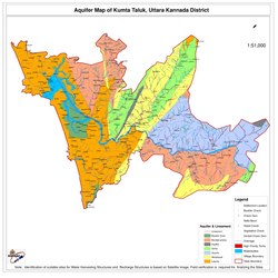
 Taluk Map of Kumta | |
| Coordinates: 14°25′N 74°24′E / 14.42°N 74.4°E | |
| Country | |
| State | Karnataka |
| Region | Kanara |
| District | Uttara Kannada |
| Government | |
| • Type | Town Municipal Council |
| • MLA | Dinakar Keshav Shetty |
| Area | |
• Total | 15.34 km2 (5.92 sq mi) |
| • Rank | 9th |
| Elevation | 2 m (7 ft) |
| Population (2011) | |
• Total | 29,266 |
| • Rank | 3rd in UK |
| • Density | 1,957.2/km2 (5,069/sq mi) |
| Languages | |
| • Official | Kannada |
| • Local | Konkani |
| Time zone | UTC+5:30 (IST) |
| PIN | 581 343 |
| Telephone code | +91-(0)8386 |
| Vehicle registration | KA-47 |
| Literacy | 90.01% |
| Sex ratio | 990 ♂/♀ |
| Lok Sabha Constituency | Uttara Kannada (Lok Sabha constituency) |
| Climate | Monsoon (Köppen) |
| Website | kumatatown |
Kumta is a town and taluk in the Uttara Kannada district of Karnataka, India.[1] It is one of the important stations along the Konkan Railway line running between Mumbai and Mangalore.[2]
The 36th Kannada Sahithya Sammelana was held in Kumta in 1956, under the presidency of V. Seetharamaiah.
Geography
[edit]The city of Kumta is located on the Arabian Sea coast in the district of North Kannada in the state of Karnataka. Kumta is adjacent to the vast western ghats 14°25′N 74°24′E / 14.42°N 74.4°E. It has an average elevation of 3 metres (9 feet).
To the north of city, the major Aghanashini river joins the Arabian Sea on her way rendering stunning scenery. The town of Gokarna near Kumta is famous for beaches. A nearby Rock Climbing spot called Yana is also beautiful with its massive black rock formations and nature trails.[citation needed]

Transportation
[edit]Road
[edit]Kumta is very well connected by road. One of the busiest highway National Highway 66 (NH 66-Panvel-Kochi-Kanyakumari) passes through Kumta. Kumta is also connected to State Highway-142 (SH 142 - Kumta-Sirsi) and also to Kumta-Siddapur Road It connects the NH 69 in Talaguppa. The halkar village situated in near NH66.
The North Western Karnataka Road Transport Corporation (NWKRTC) is the state run bus service in Kumta.[citation needed]
Rail
[edit]Kumta station is served by the Netravati Express train run by Konkan Railways.[3]
Kumta rail connects Mangalore and Goa which further connects to Bombay) Kumta station is also served by Matsyagandha Express, CSMT Manglore Express and many more
See also
[edit]References
[edit]- ^ "Unauthorized Request Blocked". Archived from the original on 15 February 2017. Retrieved 15 February 2017.
- ^ "Kumata TMC". Kumta Town Municipal Council.
- ^ "(Train Schedule / 16345 Netravati Express)". Passenger Info. Konkan Railways. Retrieved 28 October 2018.
External links
[edit]- . Encyclopædia Britannica (11th ed.). 1911.

