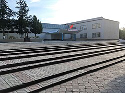
Toktogul
Appearance
(Redirected from Kodul'-Su)
Toktogul
Toктогул | |
|---|---|
 | |
| Coordinates: 41°52′20″N 72°56′20″E / 41.87222°N 72.93889°E | |
| Country | |
| Region | Jalal-Abad Region |
| District | Toktogul District |
| Population (2021) | |
| • Total | 20,577 |
Toktogul (Kyrgyz: Toктогул, known until 31 July 1957 as Muztör (Kyrgyz: Музтөр)), is a city (since 2012)[1] in Jalal-Abad Region of Kyrgyzstan. Its population was 20,577 in 2021.[2] It is the administrative seat of Toktogul District.[3]
It is named after its most famous son: the poet and musician Toktogul Satilganov. Toktogul was born in Kushchusu,[4] a village now submerged in the Toktogul Reservoir.[5][6] It is located on the northern shore of the Toktogul reservoir. To the south, highway M41 curves around the eastern end of the reservoir toward Karaköl and Jalal-Abad city. To the north the road goes up the Chychkan valley into Talas Region on its way to Bishkek.
Population
[edit]| Year | Pop. | ±% p.a. |
|---|---|---|
| 1970 | 8,851 | — |
| 1979 | 12,391 | +3.81% |
| 1989 | 16,381 | +2.83% |
| 1999 | 16,101 | −0.17% |
| 2009 | 16,429 | +0.20% |
| 2021 | 20,577 | +1.89% |
| Note: resident population; Sources:[7][2] | ||
Climate
[edit]| Climate data for Toktogul (1991–2020) | |||||||||||||
|---|---|---|---|---|---|---|---|---|---|---|---|---|---|
| Month | Jan | Feb | Mar | Apr | May | Jun | Jul | Aug | Sep | Oct | Nov | Dec | Year |
| Daily mean °C (°F) | −4.8 (23.4) |
−2.5 (27.5) |
5.4 (41.7) |
13.3 (55.9) |
17.5 (63.5) |
21.0 (69.8) |
24.0 (75.2) |
24.1 (75.4) |
19.8 (67.6) |
12.4 (54.3) |
5.6 (42.1) |
−1.5 (29.3) |
11.2 (52.2) |
| Source: NOAA[8] | |||||||||||||
References
[edit]- ^ "Law 27 September 2012 No. 168 on the transformation of individual urban settlements of the Kyrgyz Republic and relating them to the category of village or city". cbd.minjust.gov.kg (in Russian). Retrieved 2021-12-16.
- ^ a b "Population of regions, districts, towns, urban-type settlements, rural communities and villages of Kyrgyz Republic" (XLS) (in Russian). National Statistics Committee of the Kyrgyz Republic. 2021. Archived from the original on 10 November 2021.
- ^ "Classification system of territorial units of the Kyrgyz Republic" (in Kyrgyz). National Statistics Committee of the Kyrgyz Republic. May 2021. pp. 29–30.
- ^ Токтогул Сатылганов in the Great Soviet Encyclopedia (in Russian) – via Great Scientific Library
- ^ Kushchusu on GeoNames.
- ^ Soviet military map K-43 (1:1,000,000)
- ^ "2009 population and housing census of the Kyrgyz Republic: Jalal-Abad Region" (PDF) (in Russian). National Statistics Committee of the Kyrgyz Republic. 2010. p. 303.
- ^ "Climate Normals 1991–2020". National Oceanic and Atmospheric Administration. Retrieved 1 November 2023.


