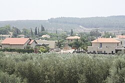
Kfar Bin Nun
Kfar Bin Nun
כְּפַר בִּן-נוּן كفر بن نون | |
|---|---|
 | |
| Coordinates: 31°51′41″N 34°57′12″E / 31.86139°N 34.95333°E | |
| Country | Israel |
| District | Central |
| Council | Gezer |
| Affiliation | Agricultural Union |
| Founded | 1952 |
| Founded by | Agricultural Union |
| Population (2022)[1] | 748 |
Kfar Bin Nun (Hebrew: כְּפַר בִּן-נוּן, lit. The village of Bin-Nun) is a moshav in central Israel. Located in the Ayalon Valley, it falls under the jurisdiction of Gezer Regional Council. In 2022 it had a population of 748.[1]
History
[edit]The moshav was founded in 1952 by the Agricultural Union on the land of the depopulated Palestinian village of al-Qubab.[2][3]
It was initially named Mishmar Ayalon Bet as it was located at the road junction to the existing Mishmar Ayalon, which had been established two years before, but was later renamed Kfar Bin Nun after Operation Bin Nun, which was named itself after the second name of Joshua (1:1), who fought here in the Ayalon valley (Joshua 10:12).[4][5][6] During two efforts, IDF did not succeed to capture Latrun during the 1948 Arab–Israeli War.
Until the Six-Day War in 1967, it was classed as a border settlement, which meant it was entitled to financial compensation for the attacks it suffered due to its proximity to the Jordanian border.[citation needed]
References
[edit]- ^ a b "Regional Statistics". Israel Central Bureau of Statistics. Retrieved 21 March 2024.
- ^ Khalidi, W. (1992). All That Remains: The Palestinian Villages Occupied and Depopulated by Israel in 1948. Washington D.C.: Institute for Palestine Studies. p. 407. ISBN 0-88728-224-5.
- ^ Morris, Benny (2004). The Birth of the Palestinian Refugee Problem Revisited. Cambridge: Cambridge University Press. p. xxi, settlement #84. ISBN 978-0-521-00967-6.
- ^ Carta's Official Guide to Israel and Complete Gazetteer to all Sites in the Holy Land. (3rd edition 1993) Jerusalem, Carta, p.259, ISBN 965-220-186-3 (English)
- ^ Yitzhaki, Aryeh (ed.). מדריך ישראל: אנציקלופדיה שימושית לידיעת הארץ [Israel Guide: An Encyclopedia for the Study of the Land] (in Hebrew). Vol. 9: Judea. Jerusalem, Israel: Keter Press. p. 383.
- ^ Bitan, Hanna: 1948-1998: Fifty Years of 'Hityashvut': Atlas of Names of Settlements in Israel, Jerusalem 1999, Carta, p.32, ISBN 965-220-423-4 (Hebrew)
External links
[edit]- Official website (in Hebrew)


