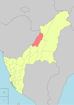
Jiasian District
23°05′N 120°35′E / 23.083°N 120.583°E
Jiasian
甲仙區 Jiaxian[1] | |
|---|---|
| Jiasian District[2] | |
 | |
 Jiasian District in Kaohsiung City | |
| Country | Taiwan |
| Region | Southern Taiwan |
| Population (October 2023) | |
| • Total | 5,581 |
| Website | jiasian-en |
Jiasian District[2][3][4][5][6][7][8] (Chinese: 甲仙區; Hanyu Pinyin: Jiǎxiān Qū; Tongyong Pinyin: Jiǎsian Cyu; Wade–Giles: Chia3-hsien1 Ch'ü1) is a rural district in Kaohsiung City, Taiwan. Located far from the coast, the township is regarded as a gateway to Taiwan's Central Mountain Range.
History
[edit]

Qing Dynasty
[edit]During the reign of Qianlong Emperor of Qing Dynasty, there was a person named Jiasian who came to the area to develop the land. Later on, people from Fujian and Guangdong migrated there to settle down. The government also established an office in the area for administration purpose.[9]
Empire of Japan
[edit]After the handover of Taiwan from Qing Dynasty to Empire of Japan in 1895, the government established Aliguan police station in the area and applied police presence in 1902. In 1905, more than 2,000 Japanese people migrated to the area to work in camphor production by establishing Taiwan Camphor Production Enterprise. In 1920, the area was named Jiasian Village. Local and legislative offices were established including village chief and committee members. In 1942, tribal societies were further established in each village with one leader for each society.[9]
Republic of China
[edit]After the handover of Taiwan from Japan to the Republic of China in 1945, Jiasian was organized as a rural township of Kaohsiung County. On 25 December 2010, Kaohsiung County was merged with Kaohsiung City and Jiasian was upgraded to a district of the city.
In August 2019, some residents living in high-risk areas of Jiasian District were evacuated from their homes after heavy rain and flash flooding.[10]
Geography
[edit]- Area: 124.03 km2
- Population: 5,581 people (October 2023)
Much of the township is between 200 and 500 metres (660 and 1,640 feet) above sea level.
Administrative divisions
[edit]- Baolong Village (寶隆里)
- Datian Village (大田里)
- Dong'an Village (東安里)
- Guanshan Village
- He'an Village (和安里)
- Xi'an Village (西安里)
- Siaolin Village (Xiaolin)
In Taiwan, "village" (里) is a level of administrative division that under a rural township. The main town of Jiasian is divided into three villages: Dong'an, Xi'an, and He'an.
Economy
[edit]Situated at the intersection of Highway 20 (the Southern Cross-Island Highway) and Highway 21, Jiasian's downtown serves as a market center for local farmers and tourists. The most famous local crop is taro. Shops sell taro-flavored ice cream, taro cookies, and other taro products. The township is also known for its bamboo shoots and plums.[11]
Tourist attractions
[edit]- Cemetery of Zhenghaijun
- Jiaxian Bridge
- Jiasianpu Memorial Monument
- Jiasian Water Park
- Jiasian Petrified Fossil Museum
- Mount Baiyun
- Mount Liouyi
- Mount Neiying
- Mount Waiying
- Mount Zion (Chinese: 錫安山; pinyin: Xí'an Shan),[12] a Christian hamlet.
- Xiaolin Pingpu Cultural Museum
- Xiaolin Village Memorial Park
Transportation
[edit]
Bus station in the district is Jiaxian Station of Kaohsiung Bus.
See also
[edit]References
[edit]- ^ 臺灣地區鄉鎮市區級以上行政區域名稱中英對照表 (PDF). Online Translation System of Geographic Name, Ministry of Interior. 16 June 2011. pp. 4–5. Archived from the original (PDF) on 25 March 2012.
高雄市 Kaohsiung City{...}甲仙區 Jiaxian District
- ^ a b "Administrative Districts". 高雄市政府. 30 September 2016. Retrieved 4 April 2017.
Jiasian District:
- ^ "About Jiasian". Jiasian District Office. Retrieved 29 July 2019.
Jiasian Township is located at the northeast end of Kaohsiung County,{...}Address: No.50, Jhongshan Rd., Jiasian District, Kaohsiung City 84742, Taiwan (R.O.C.)
- ^ Jiasian (Variant - V) at GEOnet Names Server, United States National Geospatial-Intelligence Agency
- ^ Eryk Smith (22 January 2018). "OPINION: Should Kaohsiung Spend US$100M Repairing Rural Roads?". The News Lens. Retrieved 29 July 2019.
the Aug. 8, 2009, series of mudslides and floods triggered by Typhoon Morakot that buried alive at least 400 souls in Jiasian (甲仙區) District's Siaolin Village (小林村).
- ^ Liu, Chia-Yun; Tsang, Yun-Chung; Shieh, Chjeng-Lun; Lu, Ming-Hong; Chen, Nan-Huei (April 2018). "Bed-load monitoring via Japanese pipe-hydrophone- case study in Kaohsiung, Taiwan". EGU General Assembly Conference Abstracts: 3194. Bibcode:2018EGUGA..20.3194L.
The study area of this paper is located in Yokaung River, a mountain torrent in Kaohsiung city, Jiasian District.
- ^ Chen Ting-fang (October 2019). "Camphor Trees Recall Jiasian's Captivating History". Love Kaohsiung 愛·高雄. No. 4. Translated by Hou Ya-ting. Information Bureau, Kaohsiung City Government. p. 3.
Taro from Kaohsiung's Jiasian District enjoys an excellent reputation.
- ^ 1.7-鄉鎮市區戶口數 [Population for Township and District]. Ministry of the Interior (in Chinese (Taiwan) and English). August 2020. Retrieved 21 September 2020.
甲仙區 Jiasian District 124.0340 2,297 5,907 3,123 2,784 112.18 2.57 48
- ^ a b "History".
- ^ "CWB issues heavy rain warnings for southern Taiwan". Taipei Times. 17 August 2019. Retrieved 23 October 2019.
Troops also assisted local government units in Liouguei (六龜), Jiasian (甲仙) and Shanlin (杉林) districts in Kaohsiung to evacuate residents from high-risk areas as a pre-emptive measure to ensure their safety, Wu said.
- ^ "Kaohsiung's Jiaxian Bridge opens to bring tourists back". Taiwan News. 2010-06-27. Archived from the original on 2016-03-04. Retrieved 2010-07-09.
- ^ "錫安山" ("Mt. Zion") Archived 2011-07-07 at the Wayback Machine atlaspost.com, in Chinese

